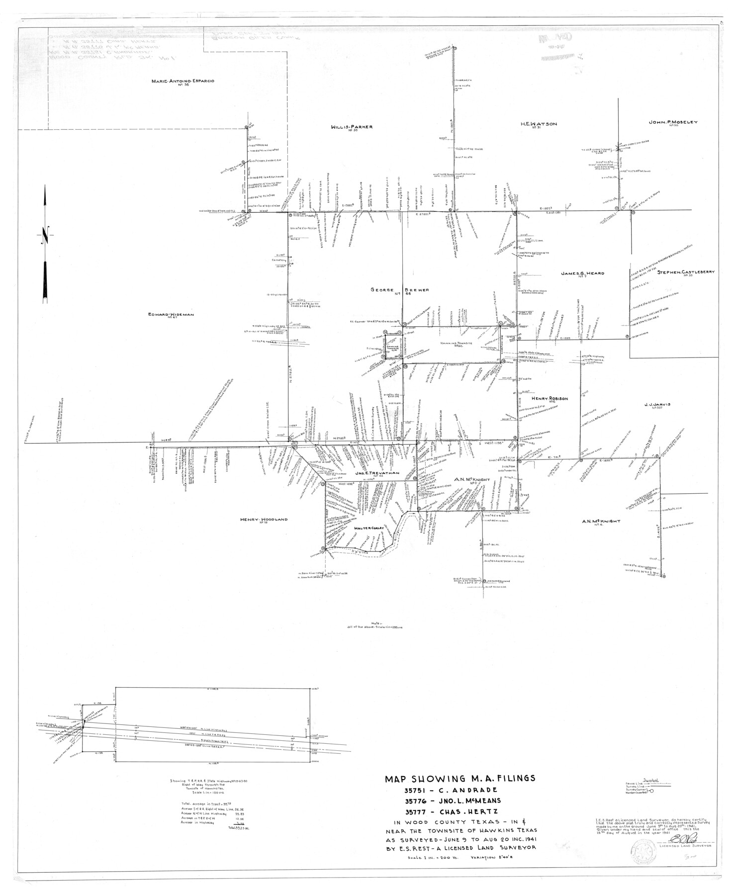
Wood County Rolled Sketch 1
Map showing M.A. filings: 35751 - C. Andrade, 35776 - Jno. L. McMeans, 35777 - Chas. Hertz in Wood County, Texas in & near the townsite of Hawkins, Texas
-
Map/Doc
10159
-
Collection
General Map Collection
-
Object Dates
1941/8/20 (Survey Date)
1941/9/3 (File Date)
1941/8/28 (Creation Date)
-
People and Organizations
E.S. Rest (Surveyor/Engineer)
-
Counties
Wood
-
Subjects
Cadastral Surveying Rolled Sketch
-
Height x Width
53.2 x 43.8 inches
135.1 x 111.3 cm
-
Scale
1" = 200 varas
Part of: General Map Collection
Moore County Working Sketch 14
![71196, Moore County Working Sketch 14, General Map Collection](https://historictexasmaps.com/wmedia_w700/maps/71196.tif.jpg)
Print $20.00
- Digital $50.00
Moore County Working Sketch 14
Size 32.7 x 19.8 inches
Map/Doc 71196
Gaines County Working Sketch 3
![69303, Gaines County Working Sketch 3, General Map Collection](https://historictexasmaps.com/wmedia_w700/maps/69303.tif.jpg)
Print $20.00
- Digital $50.00
Gaines County Working Sketch 3
Size 45.6 x 43.8 inches
Map/Doc 69303
Goliad County
![77291, Goliad County, General Map Collection](https://historictexasmaps.com/wmedia_w700/maps/77291.tif.jpg)
Print $20.00
- Digital $50.00
Goliad County
1946
Size 40.9 x 43.6 inches
Map/Doc 77291
Webb County Working Sketch 43
![72408, Webb County Working Sketch 43, General Map Collection](https://historictexasmaps.com/wmedia_w700/maps/72408.tif.jpg)
Print $20.00
- Digital $50.00
Webb County Working Sketch 43
Size 18.4 x 27.5 inches
Map/Doc 72408
El Paso County Working Sketch 22
![69044, El Paso County Working Sketch 22, General Map Collection](https://historictexasmaps.com/wmedia_w700/maps/69044.tif.jpg)
Print $20.00
- Digital $50.00
El Paso County Working Sketch 22
Size 21.6 x 20.0 inches
Map/Doc 69044
Map of the International and Great Northern Railroad between Austin and San Antonio, Texas
![64777, Map of the International and Great Northern Railroad between Austin and San Antonio, Texas, General Map Collection](https://historictexasmaps.com/wmedia_w700/maps/64777.tif.jpg)
Print $40.00
- Digital $50.00
Map of the International and Great Northern Railroad between Austin and San Antonio, Texas
1881
Size 43.2 x 96.0 inches
Map/Doc 64777
Jefferson County Rolled Sketch 34
![9296, Jefferson County Rolled Sketch 34, General Map Collection](https://historictexasmaps.com/wmedia_w700/maps/9296.tif.jpg)
Print $20.00
- Digital $50.00
Jefferson County Rolled Sketch 34
1957
Size 43.9 x 34.6 inches
Map/Doc 9296
Wichita County Working Sketch 5
![72514, Wichita County Working Sketch 5, General Map Collection](https://historictexasmaps.com/wmedia_w700/maps/72514.tif.jpg)
Print $20.00
- Digital $50.00
Wichita County Working Sketch 5
Size 18.2 x 27.0 inches
Map/Doc 72514
[Surveys on the Neches River]
![220, [Surveys on the Neches River], General Map Collection](https://historictexasmaps.com/wmedia_w700/maps/220.tif.jpg)
Print $2.00
- Digital $50.00
[Surveys on the Neches River]
1845
Size 6.0 x 3.8 inches
Map/Doc 220
Milam County Rolled Sketch 2
![6774, Milam County Rolled Sketch 2, General Map Collection](https://historictexasmaps.com/wmedia_w700/maps/6774.tif.jpg)
Print $20.00
- Digital $50.00
Milam County Rolled Sketch 2
1954
Size 21.9 x 24.8 inches
Map/Doc 6774
Map of east part of West Bay & SW part of Galveston Bay, Galveston County showing subdivision for mineral development
![2975, Map of east part of West Bay & SW part of Galveston Bay, Galveston County showing subdivision for mineral development, General Map Collection](https://historictexasmaps.com/wmedia_w700/maps/2975.tif.jpg)
Print $20.00
- Digital $50.00
Map of east part of West Bay & SW part of Galveston Bay, Galveston County showing subdivision for mineral development
1951
Size 32.6 x 37.6 inches
Map/Doc 2975
Flight Mission No. DCL-3C, Frame 156, Kenedy County
![85804, Flight Mission No. DCL-3C, Frame 156, Kenedy County, General Map Collection](https://historictexasmaps.com/wmedia_w700/pdf_converted_jpg/qi_pdf_thumbnail_33001.jpg)
Print $20.00
- Digital $50.00
Flight Mission No. DCL-3C, Frame 156, Kenedy County
1943
Size 18.5 x 22.3 inches
Map/Doc 85804
You may also like
Eastland County Working Sketch 45
![68826, Eastland County Working Sketch 45, General Map Collection](https://historictexasmaps.com/wmedia_w700/maps/68826.tif.jpg)
Print $20.00
- Digital $50.00
Eastland County Working Sketch 45
Size 31.3 x 43.7 inches
Map/Doc 68826
Wilbarger County Aerial Photograph Index Sheet 5
![83754, Wilbarger County Aerial Photograph Index Sheet 5, General Map Collection](https://historictexasmaps.com/wmedia_w700/pdf_converted_jpg/qi_pdf_thumbnail_30975.jpg)
Print $20.00
- Digital $50.00
Wilbarger County Aerial Photograph Index Sheet 5
1950
Size 22.3 x 18.0 inches
Map/Doc 83754
Hemphill County, Texas
![549, Hemphill County, Texas, Maddox Collection](https://historictexasmaps.com/wmedia_w700/maps/549-1.tif.jpg)
Print $20.00
- Digital $50.00
Hemphill County, Texas
1880
Size 19.7 x 18.6 inches
Map/Doc 549
Presidio County Rolled Sketch 4
![10733, Presidio County Rolled Sketch 4, General Map Collection](https://historictexasmaps.com/wmedia_w700/maps/10733.tif.jpg)
Print $40.00
- Digital $50.00
Presidio County Rolled Sketch 4
Size 19.1 x 69.8 inches
Map/Doc 10733
Flight Mission No. CRE-3R, Frame 37, Jackson County
![85383, Flight Mission No. CRE-3R, Frame 37, Jackson County, General Map Collection](https://historictexasmaps.com/wmedia_w700/pdf_converted_jpg/qi_pdf_thumbnail_32584.jpg)
Print $20.00
- Digital $50.00
Flight Mission No. CRE-3R, Frame 37, Jackson County
1956
Size 18.5 x 22.3 inches
Map/Doc 85383
Bosque County Sketch File 28
![14813, Bosque County Sketch File 28, General Map Collection](https://historictexasmaps.com/wmedia_w700/pdf_converted_jpg/qi_pdf_thumbnail_9503.jpg)
Print $6.00
- Digital $50.00
Bosque County Sketch File 28
1888
Size 7.3 x 10.3 inches
Map/Doc 14813
Map of Ramsey State Farm, Brazoria County, Texas
![62997, Map of Ramsey State Farm, Brazoria County, Texas, General Map Collection](https://historictexasmaps.com/wmedia_w700/maps/62997.tif.jpg)
Print $20.00
- Digital $50.00
Map of Ramsey State Farm, Brazoria County, Texas
Size 29.0 x 37.1 inches
Map/Doc 62997
Sketch Showing D. Rubin Surveys
![91165, Sketch Showing D. Rubin Surveys, Twichell Survey Records](https://historictexasmaps.com/wmedia_w700/maps/91165-1.tif.jpg)
Print $20.00
- Digital $50.00
Sketch Showing D. Rubin Surveys
1926
Size 35.1 x 24.5 inches
Map/Doc 91165
Map of Texas compiled from surveys recorded in the Land Office of Texas and other official surveys
![96435, Map of Texas compiled from surveys recorded in the Land Office of Texas and other official surveys, General Map Collection](https://historictexasmaps.com/wmedia_w700/maps/96435.tif.jpg)
Print $20.00
- Digital $50.00
Map of Texas compiled from surveys recorded in the Land Office of Texas and other official surveys
Size 24.6 x 24.2 inches
Map/Doc 96435
Johnson County Sketch File 14a
![28452, Johnson County Sketch File 14a, General Map Collection](https://historictexasmaps.com/wmedia_w700/pdf_converted_jpg/qi_pdf_thumbnail_12332.jpg)
Print $6.00
- Digital $50.00
Johnson County Sketch File 14a
1862
Size 8.0 x 11.1 inches
Map/Doc 28452
Carte d'une partie de l'Amérique Séptentrionale, qui contient partie de la Nle. Espagne, et de la Louisiane
![94096, Carte d'une partie de l'Amérique Séptentrionale, qui contient partie de la Nle. Espagne, et de la Louisiane, General Map Collection](https://historictexasmaps.com/wmedia_w700/maps/94096.tif.jpg)
Print $20.00
- Digital $50.00
Carte d'une partie de l'Amérique Séptentrionale, qui contient partie de la Nle. Espagne, et de la Louisiane
1782
Size 14.1 x 18.5 inches
Map/Doc 94096
Reference Book of Burnet's, [Vehlein's] & Zavala's Colonies
![94554, Reference Book of Burnet's, [Vehlein's] & Zavala's Colonies, Historical Volumes](https://historictexasmaps.com/wmedia_w700/pdf_converted_jpg/qi_pdf_thumbnail_39143.jpg)
Reference Book of Burnet's, [Vehlein's] & Zavala's Colonies
Map/Doc 94554