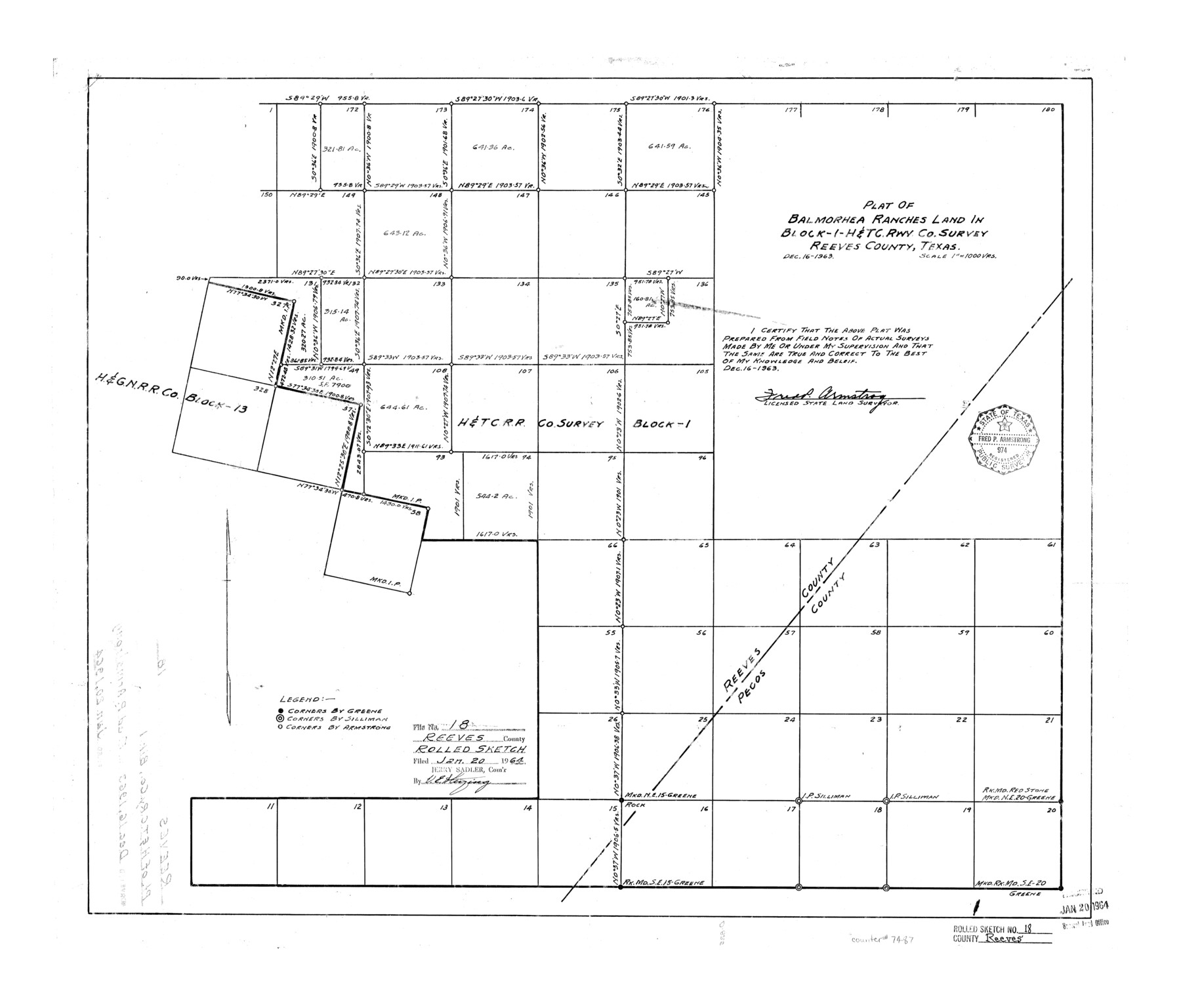
Reeves County Rolled Sketch 18
Plat of Balmorhea Ranches land in Block 1, H. & T. C. Rwy. Co. survey, Reeves County, Texas
-
Map/Doc
7487
-
Collection
General Map Collection
-
Object Dates
12/16/1963 (Creation Date)
1/20/1964 (File Date)
-
People and Organizations
Fred P. Armstrong (Surveyor/Engineer)
-
Counties
Reeves Pecos
-
Subjects
Surveying Rolled Sketch
-
Height x Width
23.4 x 27.4 inches
59.4 x 69.6 cm
-
Scale
1" = 1000 varas
-
Comments
See Reeves County Sketch File 26 (35226) for certificate of filing.
Related maps
Reeves County Sketch File 26

Print $4.00
- Digital $50.00
Reeves County Sketch File 26
1964
Size 4.1 x 8.8 inches
Map/Doc 35226
Part of: General Map Collection
Brazoria County Sketch File 26

Print $40.00
- Digital $50.00
Brazoria County Sketch File 26
Size 13.6 x 13.6 inches
Map/Doc 15028
Pecos County Working Sketch 85

Print $20.00
- Digital $50.00
Pecos County Working Sketch 85
1962
Size 45.4 x 35.7 inches
Map/Doc 71557
Crockett County Sketch File 87

Print $12.00
- Digital $50.00
Crockett County Sketch File 87
Size 12.3 x 9.0 inches
Map/Doc 19910
Map of the Texas & Pacific Railway "Gould System" Lines and Connections

Print $20.00
- Digital $50.00
Map of the Texas & Pacific Railway "Gould System" Lines and Connections
1890
Size 18.1 x 37.0 inches
Map/Doc 94102
Flight Mission No. DCL-6C, Frame 122, Kenedy County

Print $20.00
- Digital $50.00
Flight Mission No. DCL-6C, Frame 122, Kenedy County
1943
Size 18.5 x 22.4 inches
Map/Doc 85952
Controlled Mosaic by Jack Amman Photogrammetric Engineers, Inc - Sheet 3

Print $20.00
- Digital $50.00
Controlled Mosaic by Jack Amman Photogrammetric Engineers, Inc - Sheet 3
1954
Size 20.0 x 24.0 inches
Map/Doc 83447
Cooke County Sketch File 29

Print $16.00
- Digital $50.00
Cooke County Sketch File 29
1873
Size 8.2 x 11.0 inches
Map/Doc 19283
Pecos County Sketch File 18

Print $32.00
- Digital $50.00
Pecos County Sketch File 18
1884
Size 24.5 x 9.6 inches
Map/Doc 12159
Map of Harris County

Print $40.00
- Digital $50.00
Map of Harris County
1896
Size 52.7 x 66.7 inches
Map/Doc 82071
Harrison County State Real Property Sketch 2

Print $20.00
- Digital $50.00
Harrison County State Real Property Sketch 2
1986
Size 23.9 x 25.0 inches
Map/Doc 61667
Hudspeth County Rolled Sketch 28

Print $40.00
- Digital $50.00
Hudspeth County Rolled Sketch 28
Size 31.5 x 49.8 inches
Map/Doc 9208
Hays Co., 1855

Print $20.00
- Digital $50.00
Hays Co., 1855
1853
Size 20.5 x 28.6 inches
Map/Doc 3650
You may also like
Lamar County Working Sketch 2

Print $20.00
- Digital $50.00
Lamar County Working Sketch 2
Size 27.9 x 25.6 inches
Map/Doc 70263
Menard County Rolled Sketch 13

Print $20.00
- Digital $50.00
Menard County Rolled Sketch 13
1972
Size 30.8 x 24.0 inches
Map/Doc 6759
Schleicher County Sketch File 3

Print $20.00
- Digital $50.00
Schleicher County Sketch File 3
Size 28.1 x 19.9 inches
Map/Doc 12295
Waller County Sketch File 5

Print $6.00
- Digital $50.00
Waller County Sketch File 5
Size 10.7 x 14.1 inches
Map/Doc 39600
Harris County Working Sketch 92

Print $40.00
- Digital $50.00
Harris County Working Sketch 92
1974
Size 33.8 x 55.5 inches
Map/Doc 69648
Packery Channel

Print $2.00
- Digital $50.00
Packery Channel
1971
Size 9.2 x 9.1 inches
Map/Doc 2998
Bell County Boundary File 2

Print $28.00
- Digital $50.00
Bell County Boundary File 2
Size 14.6 x 22.3 inches
Map/Doc 50485
Outer Continental Shelf Leasing Maps (Louisiana Offshore Operations)

Print $20.00
- Digital $50.00
Outer Continental Shelf Leasing Maps (Louisiana Offshore Operations)
1955
Size 8.8 x 10.0 inches
Map/Doc 76091
Sulphur River, Turner Lake Sheet, Cuthand Creek

Print $20.00
- Digital $50.00
Sulphur River, Turner Lake Sheet, Cuthand Creek
1922
Size 17.5 x 18.3 inches
Map/Doc 78338
Map of Oceania engraved to illustrate Mitchell's school and family geography

Print $20.00
- Digital $50.00
Map of Oceania engraved to illustrate Mitchell's school and family geography
1839
Size 9.5 x 11.8 inches
Map/Doc 93508
[Sketch Showing Loma Blanca , El Tule and San Antonio de Encinal Leagues in Brooks County, Texas]
![624, [Sketch Showing Loma Blanca , El Tule and San Antonio de Encinal Leagues in Brooks County, Texas], Maddox Collection](https://historictexasmaps.com/wmedia_w700/maps/00624.tif.jpg)
Print $3.00
- Digital $50.00
[Sketch Showing Loma Blanca , El Tule and San Antonio de Encinal Leagues in Brooks County, Texas]
Size 9.3 x 14.2 inches
Map/Doc 624
[S. M. Walker, D. P. Allen, J. C. Guinn, J. R. Lamar and surrounding surveys]
![90335, [S. M. Walker, D. P. Allen, J. C. Guinn, J. R. Lamar and surrounding surveys], Twichell Survey Records](https://historictexasmaps.com/wmedia_w700/maps/90335-1.tif.jpg)
Print $3.00
- Digital $50.00
[S. M. Walker, D. P. Allen, J. C. Guinn, J. R. Lamar and surrounding surveys]
1912
Size 9.8 x 11.3 inches
Map/Doc 90335