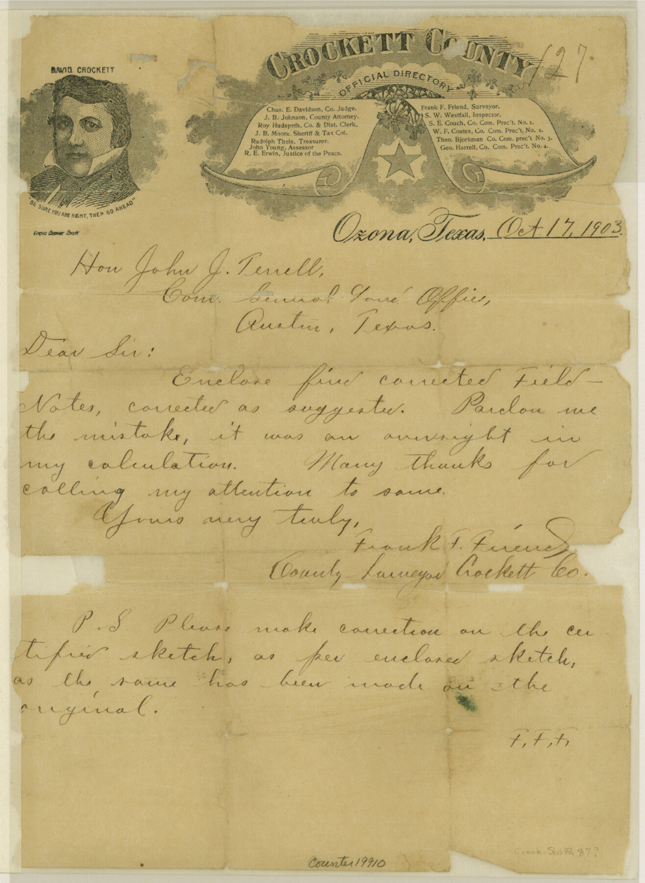
Crockett County Sketch File 87
[Connecting line from no. 31, Block M, G. C. & S. F. to no. 25, Block ST, W. T. RR. Co.]
-
Map/Doc
19910
-
Collection
General Map Collection
-
Object Dates
1903/9/28 (File Date)
1903/8/26 (Survey Date)
-
People and Organizations
Frank F. Friend (Surveyor/Engineer)
Archy Shirley (Chainman)
Jose Longoria (Chainman)
-
Counties
Crockett
-
Subjects
Surveying Sketch File
-
Height x Width
12.3 x 9.0 inches
31.2 x 22.9 cm
-
Medium
paper, manuscript
Part of: General Map Collection
Red River County Sketch File 7

Print $6.00
- Digital $50.00
Red River County Sketch File 7
1855
Size 12.7 x 8.0 inches
Map/Doc 35109
Kent County Working Sketch 14

Print $20.00
- Digital $50.00
Kent County Working Sketch 14
1965
Size 28.2 x 35.4 inches
Map/Doc 70021
Zapata County

Print $40.00
- Digital $50.00
Zapata County
1935
Size 55.8 x 41.1 inches
Map/Doc 77467
Hardin County Working Sketch 25

Print $20.00
- Digital $50.00
Hardin County Working Sketch 25
1950
Size 10.8 x 20.1 inches
Map/Doc 63423
Hill County Working Sketch 5

Print $20.00
- Digital $50.00
Hill County Working Sketch 5
2008
Size 32.2 x 31.6 inches
Map/Doc 89013
San Antonio and Aransas Pass Ry. from Survey Station 4852+100 to Survey Station 5280+00

Print $4.00
- Digital $50.00
San Antonio and Aransas Pass Ry. from Survey Station 4852+100 to Survey Station 5280+00
Size 11.8 x 18.6 inches
Map/Doc 62570
Bosque County Sketch File 12

Print $4.00
- Digital $50.00
Bosque County Sketch File 12
1863
Size 12.7 x 8.2 inches
Map/Doc 14761
Nueces County Sketch File 10

Print $4.00
- Digital $50.00
Nueces County Sketch File 10
Size 8.2 x 10.1 inches
Map/Doc 32516
Marion County Working Sketch 38

Print $20.00
- Digital $50.00
Marion County Working Sketch 38
1991
Size 35.5 x 39.9 inches
Map/Doc 70814
Webb County Sketch File 60

Print $8.00
- Digital $50.00
Webb County Sketch File 60
1943
Size 14.4 x 8.9 inches
Map/Doc 39855
Jefferson County Rolled Sketch 57

Print $20.00
- Digital $50.00
Jefferson County Rolled Sketch 57
1883
Size 18.6 x 25.9 inches
Map/Doc 6409
Val Verde County Working Sketch 108

Print $20.00
- Digital $50.00
Val Verde County Working Sketch 108
1988
Size 31.1 x 41.3 inches
Map/Doc 72243
You may also like
Van Zandt County Sketch File 39

Print $6.00
- Digital $50.00
Van Zandt County Sketch File 39
1871
Size 10.8 x 13.4 inches
Map/Doc 39484
Flight Mission No. DCL-6C, Frame 13, Kenedy County

Print $20.00
- Digital $50.00
Flight Mission No. DCL-6C, Frame 13, Kenedy County
1943
Size 18.6 x 22.3 inches
Map/Doc 85870
King County Survey made by A.C. Tackitt and W.D. Twichell

Print $20.00
- Digital $50.00
King County Survey made by A.C. Tackitt and W.D. Twichell
1916
Size 27.5 x 25.1 inches
Map/Doc 5069

[R. Sikes and Surrounding Surveys]
![91160, [R. Sikes and Surrounding Surveys], Twichell Survey Records](https://historictexasmaps.com/wmedia_w700/maps/91160-1.tif.jpg)
Print $20.00
- Digital $50.00
[R. Sikes and Surrounding Surveys]
Size 14.8 x 20.2 inches
Map/Doc 91160
[Sketch for Mineral Application 33721 - 33725 Incl. - Padre and Mustang Island]
![2878, [Sketch for Mineral Application 33721 - 33725 Incl. - Padre and Mustang Island], General Map Collection](https://historictexasmaps.com/wmedia_w700/maps/2878.tif.jpg)
Print $20.00
- Digital $50.00
[Sketch for Mineral Application 33721 - 33725 Incl. - Padre and Mustang Island]
1942
Size 29.8 x 22.7 inches
Map/Doc 2878
Hardeman County Sketch File 17

Print $2.00
- Digital $50.00
Hardeman County Sketch File 17
Size 7.8 x 6.7 inches
Map/Doc 25025
Reagan County Sketch File 18

Print $20.00
- Digital $50.00
Reagan County Sketch File 18
1936
Size 20.8 x 19.8 inches
Map/Doc 12219
Flight Mission No. BRA-3M, Frame 125, Jefferson County

Print $20.00
- Digital $50.00
Flight Mission No. BRA-3M, Frame 125, Jefferson County
1953
Size 18.6 x 21.5 inches
Map/Doc 85399
Robertson County Sketch File 10 (1)

Print $3.00
- Digital $50.00
Robertson County Sketch File 10 (1)
Size 13.0 x 10.4 inches
Map/Doc 43369
Val Verde County Sketch File Z3

Print $12.00
- Digital $50.00
Val Verde County Sketch File Z3
Size 8.8 x 7.8 inches
Map/Doc 39131
[Nueces Bay Islands and Nesting Birds]
![60312, [Nueces Bay Islands and Nesting Birds], General Map Collection](https://historictexasmaps.com/wmedia_w700/maps/60312.tif.jpg)
Print $2.00
- Digital $50.00
[Nueces Bay Islands and Nesting Birds]
1940
Size 11.4 x 7.2 inches
Map/Doc 60312