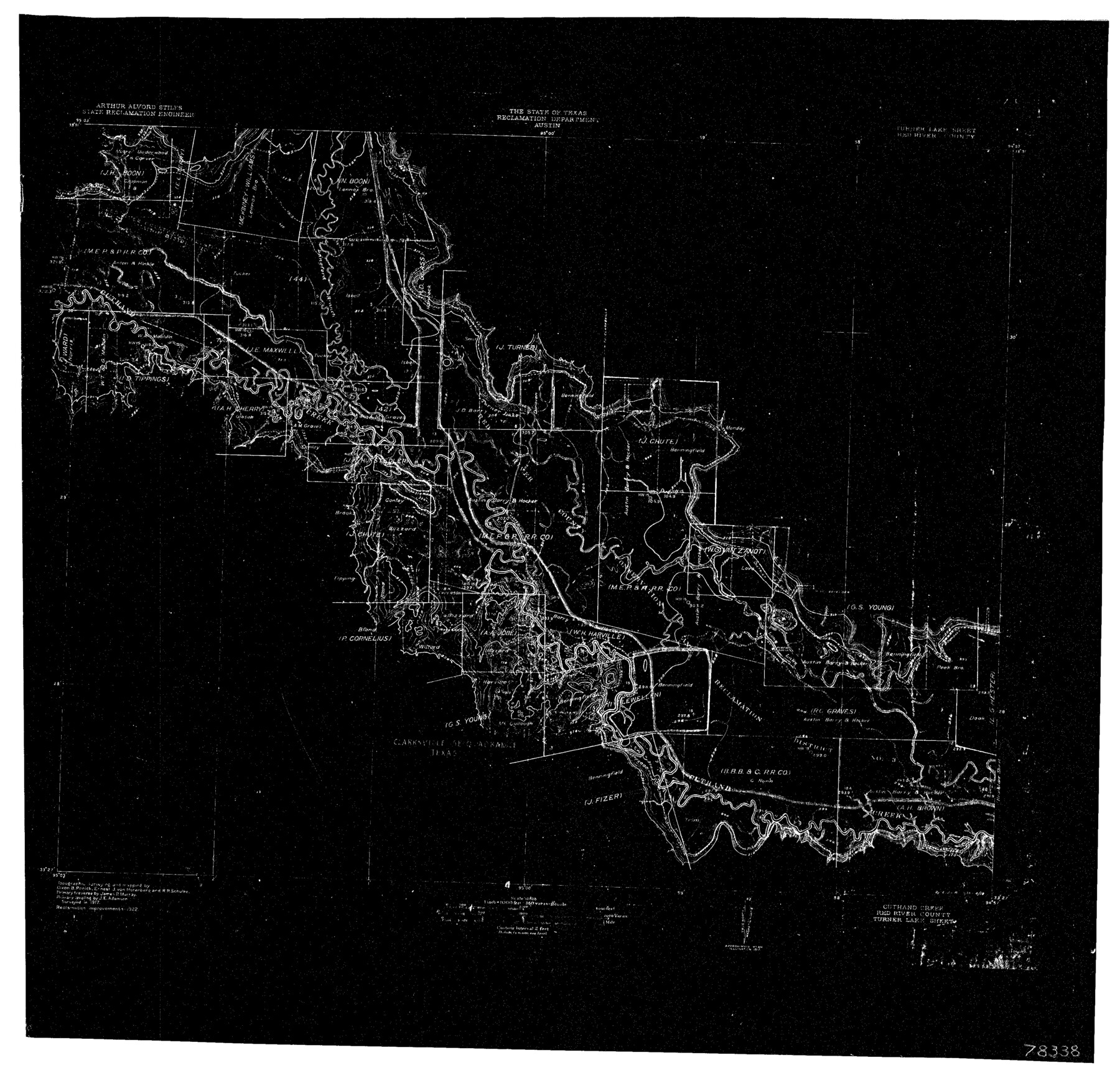
Sulphur River, Turner Lake Sheet, Cuthand Creek
-
Map/Doc
78338
-
Collection
General Map Collection
-
Object Dates
1922 (Creation Date)
-
People and Organizations
Texas State Reclamation Department (Publisher)
Ernest J. von Rosenberg (Compiler)
Ernest J. von Rosenberg (Draftsman)
Dixon B. Penick (Surveyor/Engineer)
Ernest J. von Rosenberg (Surveyor/Engineer)
R.P. Schulke (Surveyor/Engineer)
-
Counties
Red River
-
Subjects
River Surveys Topographic
-
Height x Width
17.5 x 18.3 inches
44.5 x 46.5 cm
-
Comments
Turner Lake Sheet located between the Boxelder Sheet and the North Extension Turner Lake Sheet.
Part of: General Map Collection
Angelina County Sketch File 12

Print $4.00
- Digital $50.00
Angelina County Sketch File 12
1860
Size 14.1 x 8.1 inches
Map/Doc 12955
[Sketch for Mineral Application 33721 - 33725 Incl. - Padre and Mustang Island]
![2875, [Sketch for Mineral Application 33721 - 33725 Incl. - Padre and Mustang Island], General Map Collection](https://historictexasmaps.com/wmedia_w700/maps/2875.tif.jpg)
Print $20.00
- Digital $50.00
[Sketch for Mineral Application 33721 - 33725 Incl. - Padre and Mustang Island]
1942
Size 30.9 x 22.0 inches
Map/Doc 2875
Cottle County Sketch File A and B

Print $27.00
- Digital $50.00
Cottle County Sketch File A and B
Size 18.4 x 24.1 inches
Map/Doc 11200
Crockett County Rolled Sketch 76

Print $20.00
- Digital $50.00
Crockett County Rolled Sketch 76
1950
Size 24.6 x 26.1 inches
Map/Doc 5617
Flight Mission No. DIX-6P, Frame 124, Aransas County

Print $20.00
- Digital $50.00
Flight Mission No. DIX-6P, Frame 124, Aransas County
1956
Size 19.0 x 22.4 inches
Map/Doc 83830
Foard County Working Sketch 11

Print $20.00
- Digital $50.00
Foard County Working Sketch 11
1977
Size 26.7 x 35.6 inches
Map/Doc 69202
Culberson County Working Sketch 46

Print $20.00
- Digital $50.00
Culberson County Working Sketch 46
1971
Size 25.9 x 37.4 inches
Map/Doc 68500
Map exhibiting the lines of march passed over by the troops of the United States during the year ending June 30th, 1858 prepared by order of the Hon. J.B. Floyd, Sec. War.

Print $20.00
- Digital $50.00
Map exhibiting the lines of march passed over by the troops of the United States during the year ending June 30th, 1858 prepared by order of the Hon. J.B. Floyd, Sec. War.
1858
Size 20.0 x 20.3 inches
Map/Doc 94079
Crockett County Working Sketch 25

Print $20.00
- Digital $50.00
Crockett County Working Sketch 25
1921
Size 23.5 x 17.6 inches
Map/Doc 68358
Orange County Rolled Sketch 16

Print $20.00
- Digital $50.00
Orange County Rolled Sketch 16
Size 42.2 x 30.4 inches
Map/Doc 41813
Red River County Sketch File 19

Print $4.00
- Digital $50.00
Red River County Sketch File 19
Size 8.1 x 12.7 inches
Map/Doc 35150
Sabine River, Gladewater Sheet

Print $20.00
- Digital $50.00
Sabine River, Gladewater Sheet
1933
Size 38.5 x 30.9 inches
Map/Doc 65138
You may also like
Amistad International Reservoir on Rio Grande 91

Print $20.00
- Digital $50.00
Amistad International Reservoir on Rio Grande 91
1950
Size 28.5 x 41.0 inches
Map/Doc 75521
Robertson County Sketch File 4

Print $12.00
Robertson County Sketch File 4
1862
Size 11.0 x 8.0 inches
Map/Doc 35352
[Map of Encinal County]
![3517, [Map of Encinal County], General Map Collection](https://historictexasmaps.com/wmedia_w700/maps/3517-1.tif.jpg)
Print $20.00
- Digital $50.00
[Map of Encinal County]
1872
Size 27.9 x 21.9 inches
Map/Doc 3517
Map of Yoakum County

Print $20.00
- Digital $50.00
Map of Yoakum County
1902
Size 47.2 x 35.3 inches
Map/Doc 16934

Nueces River, Clarkwood Sheet

Print $6.00
- Digital $50.00
Nueces River, Clarkwood Sheet
1942
Size 26.9 x 36.5 inches
Map/Doc 65099
Duval County Rolled Sketch 13

Print $20.00
- Digital $50.00
Duval County Rolled Sketch 13
1937
Size 33.8 x 30.4 inches
Map/Doc 5735

St. Marks to Galveston - Sheet II

Print $20.00
- Digital $50.00
St. Marks to Galveston - Sheet II
1846
Size 26.5 x 40.5 inches
Map/Doc 97397
San Patricio County Sketch File 45

Print $20.00
- Digital $50.00
San Patricio County Sketch File 45
1943
Size 11.2 x 8.9 inches
Map/Doc 36273
Close-up: USA - Arizona, New Mexico, Utah, Colorado

Close-up: USA - Arizona, New Mexico, Utah, Colorado
Size 35.0 x 22.9 inches
Map/Doc 96843
Map of the country in the vicinity of San Antonio de Bexar reduced in part from the county map of Bexar with additions by J. Edmd. Blake, 1st Lieut Topl. Engs.

Print $20.00
- Digital $50.00
Map of the country in the vicinity of San Antonio de Bexar reduced in part from the county map of Bexar with additions by J. Edmd. Blake, 1st Lieut Topl. Engs.
1845
Size 18.3 x 26.1 inches
Map/Doc 72720