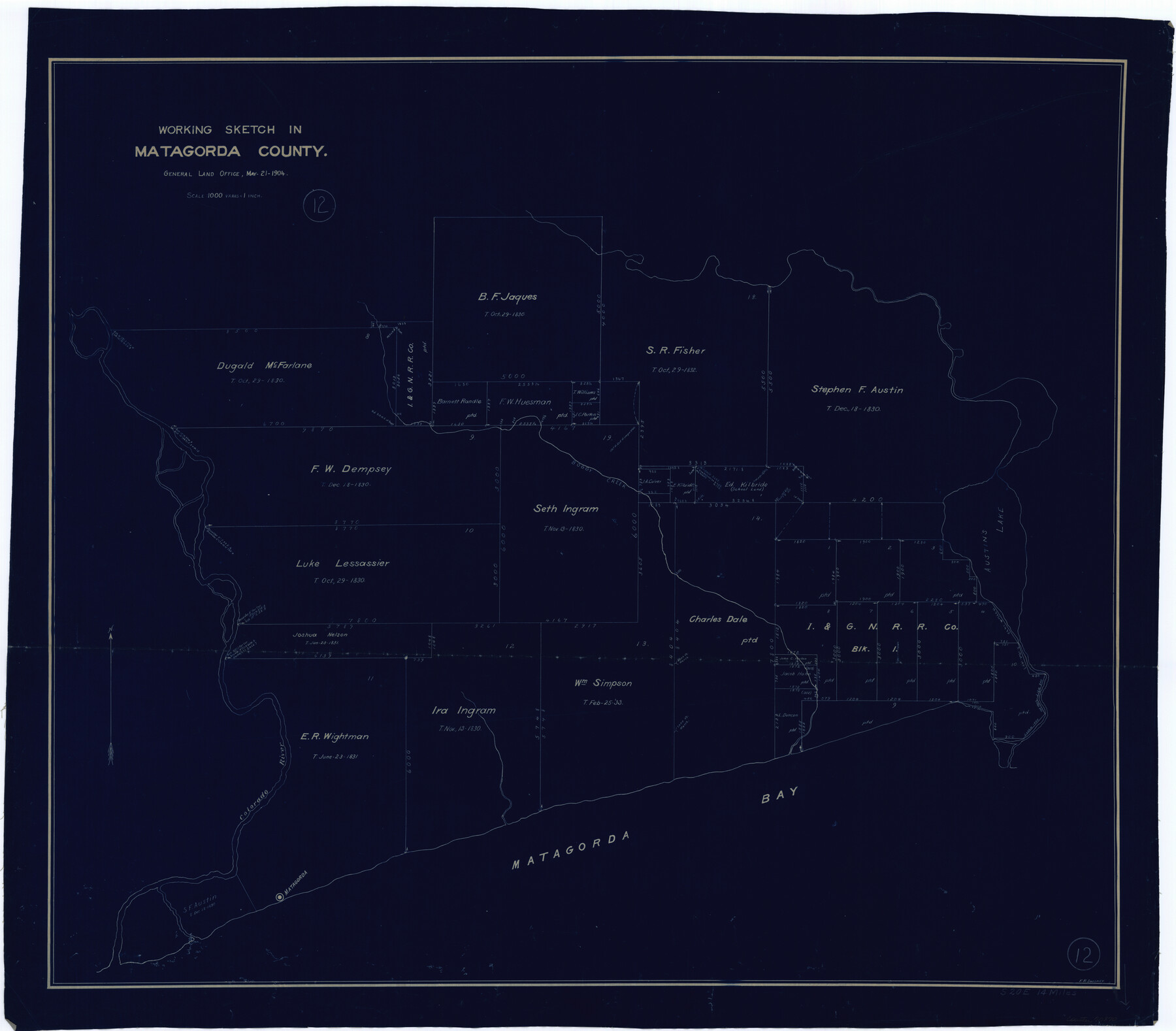
Matagorda County Working Sketch 12
-
Map/Doc
70870
-
Collection
General Map Collection
-
Object Dates
5/21/1904 (Creation Date)
-
People and Organizations
Frank R. Sweeney (Draftsman)
-
Counties
Matagorda
-
Subjects
Surveying Working Sketch
-
Height x Width
30.8 x 35.1 inches
78.2 x 89.2 cm
-
Scale
1" = 1000 varas
Part of: General Map Collection
Flight Mission No. BRA-7M, Frame 136, Jefferson County

Print $20.00
- Digital $50.00
Flight Mission No. BRA-7M, Frame 136, Jefferson County
1953
Size 18.7 x 22.5 inches
Map/Doc 85530

Map of Sabine County

Print $20.00
- Digital $50.00
Map of Sabine County
1896
Size 26.6 x 19.3 inches
Map/Doc 4010
Flight Mission No. CLL-1N, Frame 101, Willacy County

Print $20.00
- Digital $50.00
Flight Mission No. CLL-1N, Frame 101, Willacy County
1954
Size 18.3 x 22.1 inches
Map/Doc 87035
Galveston County NRC Article 33.136 Sketch 77

Print $44.00
- Digital $50.00
Galveston County NRC Article 33.136 Sketch 77
2015
Size 24.0 x 36.0 inches
Map/Doc 94991
Coryell County Sketch File 15

Print $4.00
- Digital $50.00
Coryell County Sketch File 15
1873
Size 13.0 x 8.5 inches
Map/Doc 19371
Dawson County Rolled Sketch 4
Print $20.00
- Digital $50.00
Dawson County Rolled Sketch 4
Size 24.3 x 23.9 inches
Map/Doc 5690
Hemphill County Sketch File 2

Print $8.00
- Digital $50.00
Hemphill County Sketch File 2
1900
Size 10.3 x 8.4 inches
Map/Doc 26281
Live Oak County Working Sketch 19

Print $20.00
- Digital $50.00
Live Oak County Working Sketch 19
1962
Size 27.4 x 34.5 inches
Map/Doc 70604
Topographical Map of the Rio Grande, Sheet No. 13

Print $20.00
- Digital $50.00
Topographical Map of the Rio Grande, Sheet No. 13
1912
Map/Doc 89537
Hill County Sketch File 6

Print $4.00
- Digital $50.00
Hill County Sketch File 6
1848
Size 13.9 x 8.7 inches
Map/Doc 26470
Nacogdoches County Sketch File 8

Print $20.00
- Digital $50.00
Nacogdoches County Sketch File 8
Size 20.8 x 28.7 inches
Map/Doc 42154
You may also like
The Republic County of Goliad. 1840

Print $20.00
The Republic County of Goliad. 1840
2020
Size 15.1 x 21.7 inches
Map/Doc 96150
Plat Showing the Development of Texas Counties from the Original Land Districts

Print $40.00
- Digital $50.00
Plat Showing the Development of Texas Counties from the Original Land Districts
Size 49.6 x 29.5 inches
Map/Doc 73616
Flight Mission No. DQN-3K, Frame 52, Calhoun County

Print $20.00
- Digital $50.00
Flight Mission No. DQN-3K, Frame 52, Calhoun County
1953
Size 18.4 x 22.2 inches
Map/Doc 84353
Part of Garza, Crosby, Lynn, and Lubbock Counties

Print $20.00
- Digital $50.00
Part of Garza, Crosby, Lynn, and Lubbock Counties
1912
Size 25.3 x 20.0 inches
Map/Doc 91312
Robertson County Rolled Sketch 6

Print $20.00
- Digital $50.00
Robertson County Rolled Sketch 6
Size 22.8 x 15.6 inches
Map/Doc 7512
McMullen County Working Sketch 58

Print $40.00
- Digital $50.00
McMullen County Working Sketch 58
1984
Size 61.2 x 40.0 inches
Map/Doc 70759
General Highway Map, Refugio County, Texas

Print $20.00
General Highway Map, Refugio County, Texas
1940
Size 18.3 x 25.0 inches
Map/Doc 79228
Austin County Sketch File A

Print $40.00
- Digital $50.00
Austin County Sketch File A
1895
Size 22.3 x 21.1 inches
Map/Doc 10878
Town of Wellman Situated on Parts of the Northeast 1/4 and Northwest 1/4 Section 17, Block DD

Print $20.00
- Digital $50.00
Town of Wellman Situated on Parts of the Northeast 1/4 and Northwest 1/4 Section 17, Block DD
1924
Size 14.3 x 12.3 inches
Map/Doc 92886
Wise County Working Sketch 24

Print $40.00
- Digital $50.00
Wise County Working Sketch 24
1983
Size 37.1 x 58.2 inches
Map/Doc 72638
Flight Mission No. BRA-7M, Frame 150, Jefferson County

Print $20.00
- Digital $50.00
Flight Mission No. BRA-7M, Frame 150, Jefferson County
1953
Size 18.7 x 22.4 inches
Map/Doc 85544
Bowie County Working Sketch 21

Print $20.00
- Digital $50.00
Bowie County Working Sketch 21
1968
Size 35.9 x 36.3 inches
Map/Doc 67425