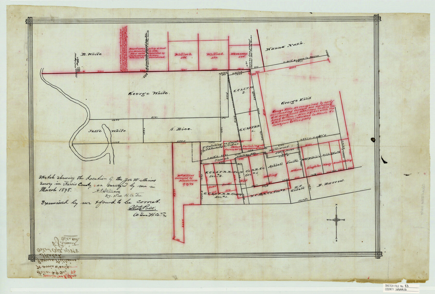
Harris County Sketch File 83
Sketch showing the location of the Jos. Williams survey in Harris County
-
Map/Doc
11671
-
Collection
General Map Collection
-
Object Dates
1898 (Creation Date)
1898 (Survey Date)
-
People and Organizations
W.A. Polk (Surveyor/Engineer)
A.E. Stinson (Surveyor/Engineer)
-
Counties
Harris
-
Subjects
Surveying Sketch File
-
Height x Width
18.5 x 27.3 inches
47.0 x 69.3 cm
-
Medium
paper, manuscript
-
Features
Boggs Channel
Part of: General Map Collection

Right-of-Way and Track Map, Texas State Railroad operated by the T. and N. O. R.R. Co.

Print $40.00
- Digital $50.00
Right-of-Way and Track Map, Texas State Railroad operated by the T. and N. O. R.R. Co.
1918
Size 24.5 x 56.1 inches
Map/Doc 64178
Corpus Christi Pass, Texas

Print $20.00
- Digital $50.00
Corpus Christi Pass, Texas
1869
Size 24.3 x 18.2 inches
Map/Doc 72965
Burnet County Working Sketch 25

Print $20.00
- Digital $50.00
Burnet County Working Sketch 25
2000
Size 24.2 x 30.3 inches
Map/Doc 67868
Erath County Working Sketch 24

Print $20.00
- Digital $50.00
Erath County Working Sketch 24
1967
Size 41.5 x 39.3 inches
Map/Doc 69105
Williamson County

Print $40.00
- Digital $50.00
Williamson County
1888
Size 39.3 x 57.1 inches
Map/Doc 16929
Map of Bee County

Print $20.00
- Digital $50.00
Map of Bee County
1879
Size 25.1 x 22.7 inches
Map/Doc 3289
San Augustine County Working Sketch 20

Print $20.00
- Digital $50.00
San Augustine County Working Sketch 20
1969
Size 15.1 x 24.0 inches
Map/Doc 63708
Galveston County NRC Article 33.136 Sketch 90

Print $144.00
- Digital $50.00
Galveston County NRC Article 33.136 Sketch 90
2021
Map/Doc 96930
Dallas County Sketch File 18

Print $6.00
- Digital $50.00
Dallas County Sketch File 18
1871
Size 15.8 x 11.0 inches
Map/Doc 20437
Liberty County Working Sketch Graphic Index - east part

Print $20.00
- Digital $50.00
Liberty County Working Sketch Graphic Index - east part
1977
Size 46.0 x 34.5 inches
Map/Doc 76620
Roberts County Working Sketch 37

Print $20.00
- Digital $50.00
Roberts County Working Sketch 37
1978
Size 26.6 x 22.5 inches
Map/Doc 63563
You may also like
Gonzales County Rolled Sketch 2

Print $20.00
- Digital $50.00
Gonzales County Rolled Sketch 2
2021
Size 24.0 x 35.9 inches
Map/Doc 96581
Borden County Working Sketch 13

Print $20.00
- Digital $50.00
Borden County Working Sketch 13
1958
Size 24.1 x 35.6 inches
Map/Doc 67473
Presidio County Working Sketch 144

Print $20.00
- Digital $50.00
Presidio County Working Sketch 144
1990
Size 20.4 x 26.6 inches
Map/Doc 71822
[Western part of Crockett County]
![90323, [Western part of Crockett County], Twichell Survey Records](https://historictexasmaps.com/wmedia_w700/maps/90323-1.tif.jpg)
Print $20.00
- Digital $50.00
[Western part of Crockett County]
Size 17.3 x 14.3 inches
Map/Doc 90323
Foard County Rolled Sketch 15

Print $20.00
- Digital $50.00
Foard County Rolled Sketch 15
1889
Size 19.9 x 38.3 inches
Map/Doc 5890
Van Zandt County Working Sketch 7

Print $20.00
- Digital $50.00
Van Zandt County Working Sketch 7
1953
Size 17.7 x 18.1 inches
Map/Doc 72257
Hood County Sketch File 4

Print $4.00
- Digital $50.00
Hood County Sketch File 4
Size 8.8 x 7.8 inches
Map/Doc 26575
Rains County Sketch File 1

Print $6.00
- Digital $50.00
Rains County Sketch File 1
Size 5.9 x 9.1 inches
Map/Doc 34942
Potter County Working Sketch Graphic Index

Print $20.00
- Digital $50.00
Potter County Working Sketch Graphic Index
1960
Size 42.3 x 33.1 inches
Map/Doc 76669
Pecos County Rolled Sketch 69

Print $20.00
- Digital $50.00
Pecos County Rolled Sketch 69
Size 37.9 x 33.8 inches
Map/Doc 9701

Flight Mission No. DAG-22K, Frame 87, Matagorda County

Print $20.00
- Digital $50.00
Flight Mission No. DAG-22K, Frame 87, Matagorda County
1953
Size 18.6 x 22.4 inches
Map/Doc 86471