Jim Hogg County Sketch File 2
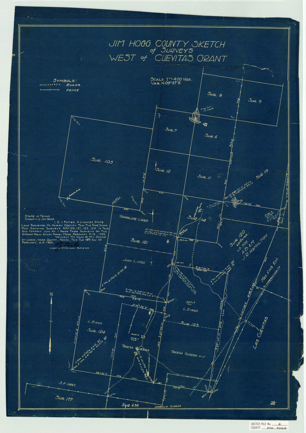
Jim Hogg County Sketch of Surveys West of Cuevitas Grant
-
Map/Doc
11884
-
Collection
General Map Collection
-
Object Dates
2/16/1926 (Creation Date)
3/4/1926 (File Date)
2/10/1926 (Survey Date)
-
People and Organizations
E.J. Foster (Surveyor/Engineer)
-
Counties
Jim Hogg
-
Subjects
Surveying Sketch File
-
Height x Width
24.9 x 17.7 inches
63.2 x 45.0 cm
-
Medium
blueprint/diazo
-
Scale
1:400
Part of: General Map Collection
Dimmit County Sketch File 61

Print $12.00
- Digital $50.00
Dimmit County Sketch File 61
1999
Size 11.4 x 8.8 inches
Map/Doc 21208
Kimble County Working Sketch 39

Print $20.00
- Digital $50.00
Kimble County Working Sketch 39
1947
Size 30.8 x 23.5 inches
Map/Doc 70107
Pecos County Rolled Sketch 164

Print $20.00
- Digital $50.00
Pecos County Rolled Sketch 164
1965
Size 30.2 x 20.1 inches
Map/Doc 7287
Nacogdoches County Working Sketch 2

Print $20.00
- Digital $50.00
Nacogdoches County Working Sketch 2
1904
Size 20.5 x 24.1 inches
Map/Doc 71218
Hays County State Real Property Sketch 3

Print $20.00
- Digital $50.00
Hays County State Real Property Sketch 3
2003
Size 24.0 x 37.2 inches
Map/Doc 96638
Roberts County Boundary File 2d

Print $20.00
- Digital $50.00
Roberts County Boundary File 2d
Size 9.1 x 28.1 inches
Map/Doc 58366
Galveston County NRC Article 33.136 Sketch 47

Print $24.00
- Digital $50.00
Galveston County NRC Article 33.136 Sketch 47
2006
Size 18.3 x 24.4 inches
Map/Doc 87504
Duval County Sketch File 34

Print $20.00
- Digital $50.00
Duval County Sketch File 34
Size 28.4 x 36.9 inches
Map/Doc 11391
Flight Mission No. BQY-15M, Frame 12, Harris County

Print $20.00
- Digital $50.00
Flight Mission No. BQY-15M, Frame 12, Harris County
1953
Size 18.7 x 22.4 inches
Map/Doc 85310
Zavala County Sketch File 15

Print $20.00
- Digital $50.00
Zavala County Sketch File 15
Size 23.3 x 22.3 inches
Map/Doc 12729
Burnet County Boundary File 1

Print $28.00
- Digital $50.00
Burnet County Boundary File 1
Size 12.8 x 8.3 inches
Map/Doc 50844
Clay County Sketch File 19

Print $5.00
- Digital $50.00
Clay County Sketch File 19
Size 9.2 x 9.9 inches
Map/Doc 18429
You may also like
Aransas County Working Sketch 20

Print $20.00
- Digital $50.00
Aransas County Working Sketch 20
1980
Size 11.9 x 24.4 inches
Map/Doc 67187
Presidio County Sketch File 111

Print $4.00
- Digital $50.00
Presidio County Sketch File 111
1885
Size 14.3 x 9.1 inches
Map/Doc 34824
Reagan County Rolled Sketch 22

Print $20.00
- Digital $50.00
Reagan County Rolled Sketch 22
Size 33.9 x 33.1 inches
Map/Doc 9817
Map of Brett Ranch situated in McMullen & La Salle Counties

Print $20.00
- Digital $50.00
Map of Brett Ranch situated in McMullen & La Salle Counties
Size 20.0 x 22.3 inches
Map/Doc 5068
Kerr County Boundary File 3

Print $6.00
- Digital $50.00
Kerr County Boundary File 3
Size 11.3 x 8.8 inches
Map/Doc 55998
[Topographical Map showing part of Miller Day Ranch in Southwest Part of Coleman County]
![81515, [Topographical Map showing part of Miller Day Ranch in Southwest Part of Coleman County], General Map Collection](https://historictexasmaps.com/wmedia_w700/maps/81515.tif.jpg)
Print $3.00
- Digital $50.00
[Topographical Map showing part of Miller Day Ranch in Southwest Part of Coleman County]
Size 11.3 x 17.3 inches
Map/Doc 81515
Crockett County Working Sketch 53

Print $20.00
- Digital $50.00
Crockett County Working Sketch 53
1948
Size 24.2 x 27.7 inches
Map/Doc 68386
Flight Mission No. CRC-4R, Frame 80, Chambers County

Print $20.00
- Digital $50.00
Flight Mission No. CRC-4R, Frame 80, Chambers County
1956
Size 18.6 x 22.4 inches
Map/Doc 84884
The United States

Print $20.00
- Digital $50.00
The United States
1907
Size 21.1 x 28.3 inches
Map/Doc 95859
Bandera County Sketch File 29

Print $40.00
- Digital $50.00
Bandera County Sketch File 29
1939
Size 17.3 x 17.4 inches
Map/Doc 10898
Upton County Working Sketch 4

Print $20.00
- Digital $50.00
Upton County Working Sketch 4
Size 21.8 x 33.9 inches
Map/Doc 69500
Hudspeth County Working Sketch 47

Print $20.00
- Digital $50.00
Hudspeth County Working Sketch 47
1984
Size 27.3 x 38.6 inches
Map/Doc 78211