Kaufman County Sketch File 10a
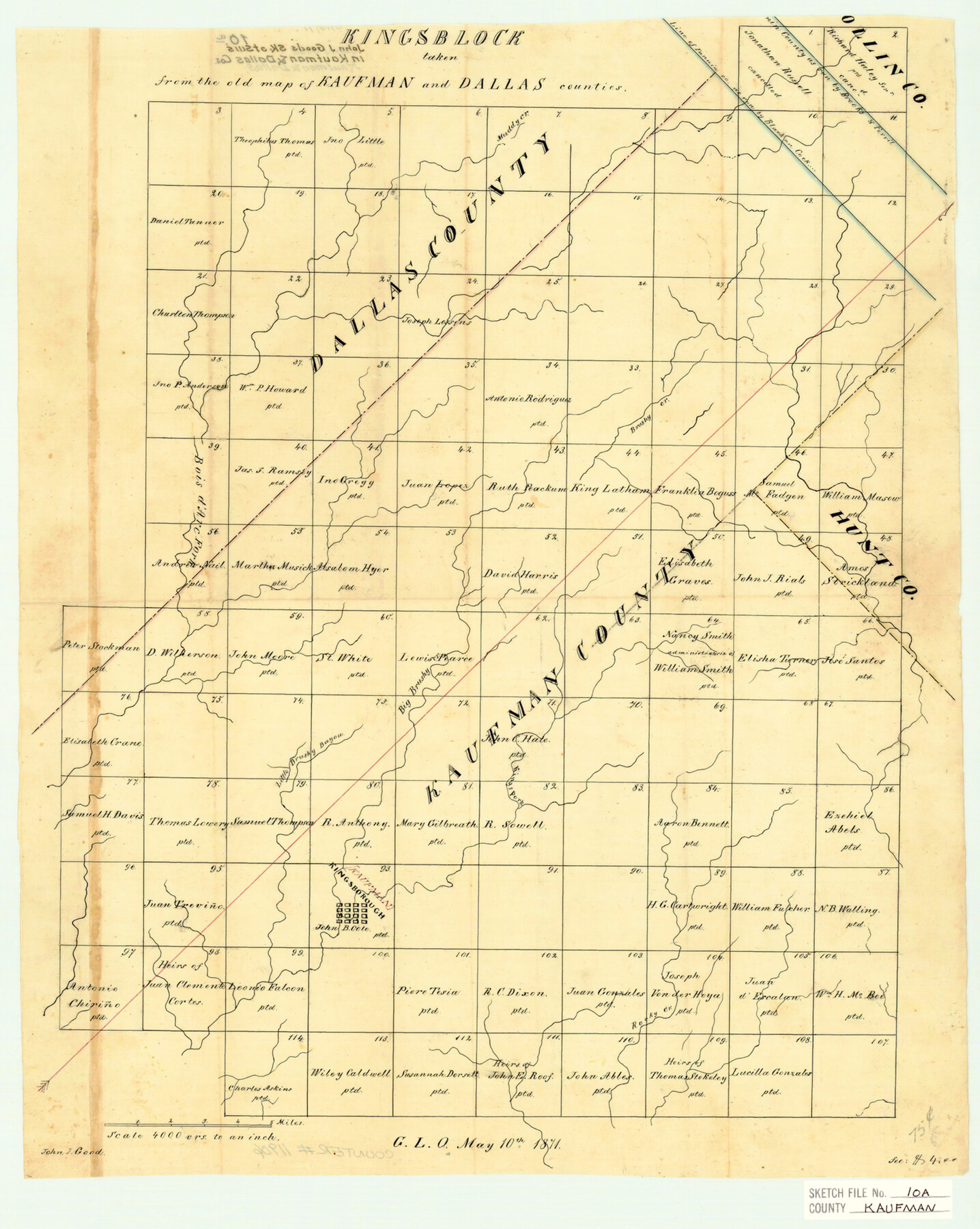
Kingsblock taken from the old map of Kaufman and Dallas Counties
-
Map/Doc
11906
-
Collection
General Map Collection
-
Object Dates
5/10/1871 (Creation Date)
-
People and Organizations
John J. Good (Surveyor/Engineer)
-
Counties
Kaufman Dallas Hunt Rockwall
-
Subjects
Surveying Sketch File
-
Height x Width
18.3 x 14.6 inches
46.5 x 37.1 cm
-
Medium
paper, manuscript
-
Scale
1" = 4000 varas
-
Features
Muddy Creek
Brushy Creek
Bois d'Arc Fork
King's Fork
Big Brushy Bayou
Little Brushy Bayou
Kingsborough
Rocky Creek
Part of: General Map Collection
Flight Mission No. CUG-1P, Frame 28, Kleberg County

Print $20.00
- Digital $50.00
Flight Mission No. CUG-1P, Frame 28, Kleberg County
1956
Size 18.6 x 22.2 inches
Map/Doc 86118
Flight Mission No. DAG-24K, Frame 158, Matagorda County

Print $20.00
- Digital $50.00
Flight Mission No. DAG-24K, Frame 158, Matagorda County
1953
Size 18.6 x 22.5 inches
Map/Doc 86572
Sutton County Rolled Sketch H

Print $40.00
- Digital $50.00
Sutton County Rolled Sketch H
Size 24.9 x 50.0 inches
Map/Doc 9973
Flight Mission No. CGI-3N, Frame 158, Cameron County

Print $20.00
- Digital $50.00
Flight Mission No. CGI-3N, Frame 158, Cameron County
1954
Size 18.5 x 22.4 inches
Map/Doc 84622
Starr County Rolled Sketch 25

Print $20.00
- Digital $50.00
Starr County Rolled Sketch 25
1939
Size 28.0 x 38.5 inches
Map/Doc 7809
Childress County Working Sketch 6

Print $20.00
- Digital $50.00
Childress County Working Sketch 6
1954
Size 19.1 x 24.3 inches
Map/Doc 68022
Hays County Sketch File 27

Print $6.00
- Digital $50.00
Hays County Sketch File 27
Size 11.2 x 8.8 inches
Map/Doc 26252
Bandera County Working Sketch 27

Print $20.00
- Digital $50.00
Bandera County Working Sketch 27
1950
Size 15.0 x 17.1 inches
Map/Doc 67623
Upshur County

Print $20.00
- Digital $50.00
Upshur County
1945
Size 37.7 x 33.5 inches
Map/Doc 77442
Map of Texas with Parts of the Adjoining States

Print $20.00
- Digital $50.00
Map of Texas with Parts of the Adjoining States
1837
Size 31.5 x 24.9 inches
Map/Doc 2114
Flight Mission No. DIX-7P, Frame 23, Aransas County

Print $20.00
- Digital $50.00
Flight Mission No. DIX-7P, Frame 23, Aransas County
1956
Size 18.7 x 22.4 inches
Map/Doc 83875
Shackelford County Sketch File 1

Print $4.00
- Digital $50.00
Shackelford County Sketch File 1
1877
Size 12.8 x 8.0 inches
Map/Doc 36570
You may also like
University of Texas System University Lands

Print $20.00
- Digital $50.00
University of Texas System University Lands
1936
Size 23.2 x 17.6 inches
Map/Doc 93236
Pecos County Rolled Sketch 178

Print $20.00
- Digital $50.00
Pecos County Rolled Sketch 178
1979
Size 38.5 x 28.7 inches
Map/Doc 7298
Flight Mission No. DIX-8P, Frame 57, Aransas County

Print $20.00
- Digital $50.00
Flight Mission No. DIX-8P, Frame 57, Aransas County
1956
Size 18.7 x 22.4 inches
Map/Doc 83888
Dépt. des Ardennes

Print $20.00
- Digital $50.00
Dépt. des Ardennes
Size 14.5 x 20.5 inches
Map/Doc 94448
Travis County Appraisal District Plat Map 2_2105

Print $20.00
- Digital $50.00
Travis County Appraisal District Plat Map 2_2105
Size 21.6 x 26.5 inches
Map/Doc 94200
Reagan County Working Sketch 46a

Print $20.00
- Digital $50.00
Reagan County Working Sketch 46a
1970
Size 34.5 x 30.4 inches
Map/Doc 71888
Letter from Jesse Grimes Suggesting a Redefinition of the Boundary Between Harris and Montgomery Counties, April 30, 1838

Print $20.00
Letter from Jesse Grimes Suggesting a Redefinition of the Boundary Between Harris and Montgomery Counties, April 30, 1838
2020
Size 15.4 x 21.7 inches
Map/Doc 96381
Jefferson County NRC Article 33.136 Sketch 3

Print $22.00
- Digital $50.00
Jefferson County NRC Article 33.136 Sketch 3
2003
Size 22.7 x 33.9 inches
Map/Doc 78610
Texas Gulf Coast Map from the Sabine River to the Rio Grande as subdivided for mineral development

Print $40.00
- Digital $50.00
Texas Gulf Coast Map from the Sabine River to the Rio Grande as subdivided for mineral development
1948
Size 48.9 x 38.0 inches
Map/Doc 2910
Matagorda County Boundary File 101

Print $10.00
- Digital $50.00
Matagorda County Boundary File 101
Size 8.9 x 7.4 inches
Map/Doc 56896
Coleman County Sketch File 25

Print $40.00
- Digital $50.00
Coleman County Sketch File 25
1872
Size 12.5 x 15.8 inches
Map/Doc 18710
Township 12 South Range 13 West, South Western District, Louisiana

Print $20.00
- Digital $50.00
Township 12 South Range 13 West, South Western District, Louisiana
1838
Size 19.5 x 24.7 inches
Map/Doc 65855