Kinney County Sketch File 33
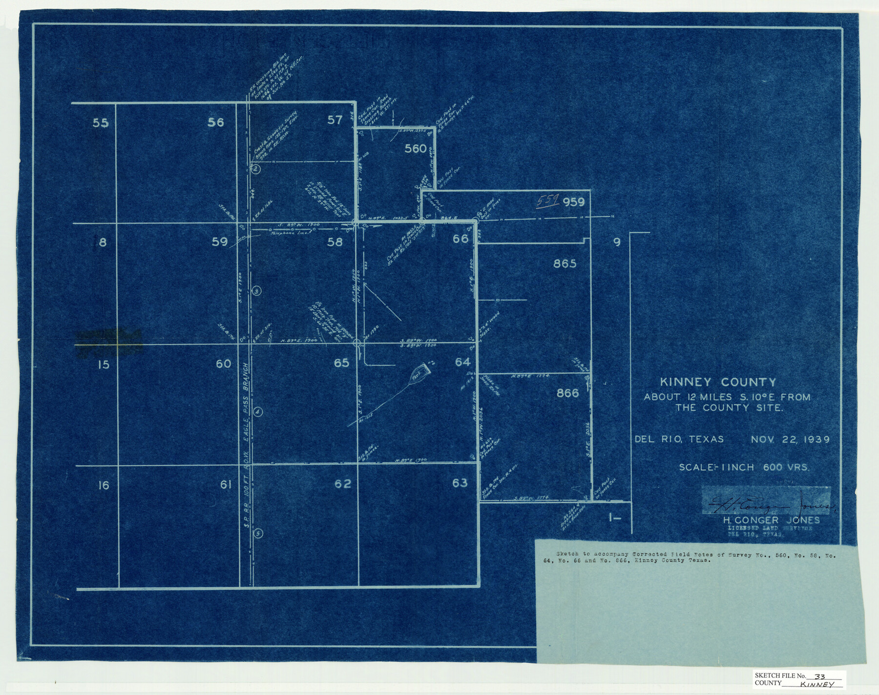
Sketch to accompany corrected field notes of survey no. 560, no. 58, no. 64, and no. 866, Kinney County, Texas
-
Map/Doc
11948
-
Collection
General Map Collection
-
Object Dates
11/22/1939 (Creation Date)
1/16/1940 (File Date)
-
People and Organizations
H. Conger Jones (Surveyor/Engineer)
-
Counties
Kinney
-
Subjects
Surveying Sketch File
-
Height x Width
18.1 x 22.8 inches
46.0 x 57.9 cm
-
Medium
blueprint/diazo
-
Scale
1" = 600 varas
-
Features
Southern Pacific Railroad Company
Part of: General Map Collection
Marion County Working Sketch 27

Print $20.00
- Digital $50.00
Marion County Working Sketch 27
1971
Size 44.8 x 41.0 inches
Map/Doc 70803
Gonzales County Rolled Sketch 1

Print $20.00
- Digital $50.00
Gonzales County Rolled Sketch 1
1917
Size 22.1 x 24.0 inches
Map/Doc 6028

Flight Mission No. DIX-3P, Frame 164, Aransas County

Print $20.00
- Digital $50.00
Flight Mission No. DIX-3P, Frame 164, Aransas County
1956
Size 17.8 x 18.0 inches
Map/Doc 83770
Gray County Sketch File 11

Print $40.00
- Digital $50.00
Gray County Sketch File 11
Size 15.0 x 13.5 inches
Map/Doc 24452
Flight Mission No. DQN-7K, Frame 12, Calhoun County

Print $20.00
- Digital $50.00
Flight Mission No. DQN-7K, Frame 12, Calhoun County
1953
Size 18.6 x 22.2 inches
Map/Doc 84463
Roberts County Working Sketch 37

Print $20.00
- Digital $50.00
Roberts County Working Sketch 37
1978
Size 26.6 x 22.5 inches
Map/Doc 63563
Real County Rolled Sketch 2

Print $40.00
- Digital $50.00
Real County Rolled Sketch 2
Size 36.9 x 66.6 inches
Map/Doc 9832
Kimble County Rolled Sketch 19

Print $20.00
- Digital $50.00
Kimble County Rolled Sketch 19
Size 38.8 x 33.6 inches
Map/Doc 9339
Flight Mission No. CRC-4R, Frame 150, Chambers County

Print $20.00
- Digital $50.00
Flight Mission No. CRC-4R, Frame 150, Chambers County
1956
Size 18.6 x 22.4 inches
Map/Doc 84913
Layout of the porciones as described in the Visita General of Reynosa, 1767

Layout of the porciones as described in the Visita General of Reynosa, 1767
2009
Size 11.0 x 8.5 inches
Map/Doc 94045
Brooks County Rolled Sketch 23

Print $40.00
- Digital $50.00
Brooks County Rolled Sketch 23
Size 42.4 x 74.4 inches
Map/Doc 8538
You may also like
[Map of Kentucky and Tennessee]
![96623, [Map of Kentucky and Tennessee], Cobb Digital Map Collection](https://historictexasmaps.com/wmedia_w700/maps/96623.tif.jpg)
Print $20.00
- Digital $50.00
[Map of Kentucky and Tennessee]
1869
Size 8.9 x 9.5 inches
Map/Doc 96623
A Survey of Lake Champlain, including Lake George, Crown Point and St. John

Print $20.00
- Digital $50.00
A Survey of Lake Champlain, including Lake George, Crown Point and St. John
1762
Size 29.0 x 20.9 inches
Map/Doc 97404
Navarro County

Print $40.00
- Digital $50.00
Navarro County
1924
Size 42.5 x 50.6 inches
Map/Doc 66951
Houston County Rolled Sketch 3

Print $57.00
- Digital $50.00
Houston County Rolled Sketch 3
1935
Size 23.5 x 23.4 inches
Map/Doc 6226
Meanders of Sulphur Fork of Red River, Red River County, Texas

Print $2.00
- Digital $50.00
Meanders of Sulphur Fork of Red River, Red River County, Texas
1841
Size 6.8 x 9.7 inches
Map/Doc 65777
Map of Survey made for Bascom Giles, General Land Commissioner, covering Bob Reid Mineral Application No. 35521

Print $20.00
- Digital $50.00
Map of Survey made for Bascom Giles, General Land Commissioner, covering Bob Reid Mineral Application No. 35521
1941
Size 26.5 x 19.1 inches
Map/Doc 91964

Houston County Working Sketch 30

Print $20.00
- Digital $50.00
Houston County Working Sketch 30
1990
Size 36.9 x 37.0 inches
Map/Doc 66260
Map of section no. 9 of a survey of Padre Island made for the Office of the Attorney General of the State of Texas

Print $40.00
- Digital $50.00
Map of section no. 9 of a survey of Padre Island made for the Office of the Attorney General of the State of Texas
1941
Size 58.3 x 42.5 inches
Map/Doc 2265
Hunt County Boundary File 5

Print $6.00
- Digital $50.00
Hunt County Boundary File 5
Size 11.2 x 8.9 inches
Map/Doc 55222
Controlled Mosaic by Jack Amman Photogrammetric Engineers, Inc - Sheet 56

Print $20.00
- Digital $50.00
Controlled Mosaic by Jack Amman Photogrammetric Engineers, Inc - Sheet 56
1954
Size 20.0 x 24.0 inches
Map/Doc 83515
[Jas. T. Williams Survey and vicinity]
![91264, [Jas. T. Williams Survey and vicinity], Twichell Survey Records](https://historictexasmaps.com/wmedia_w700/maps/91264-1.tif.jpg)
Print $20.00
- Digital $50.00
[Jas. T. Williams Survey and vicinity]
Size 15.0 x 12.0 inches
Map/Doc 91264