Angelina County Sketch File 11
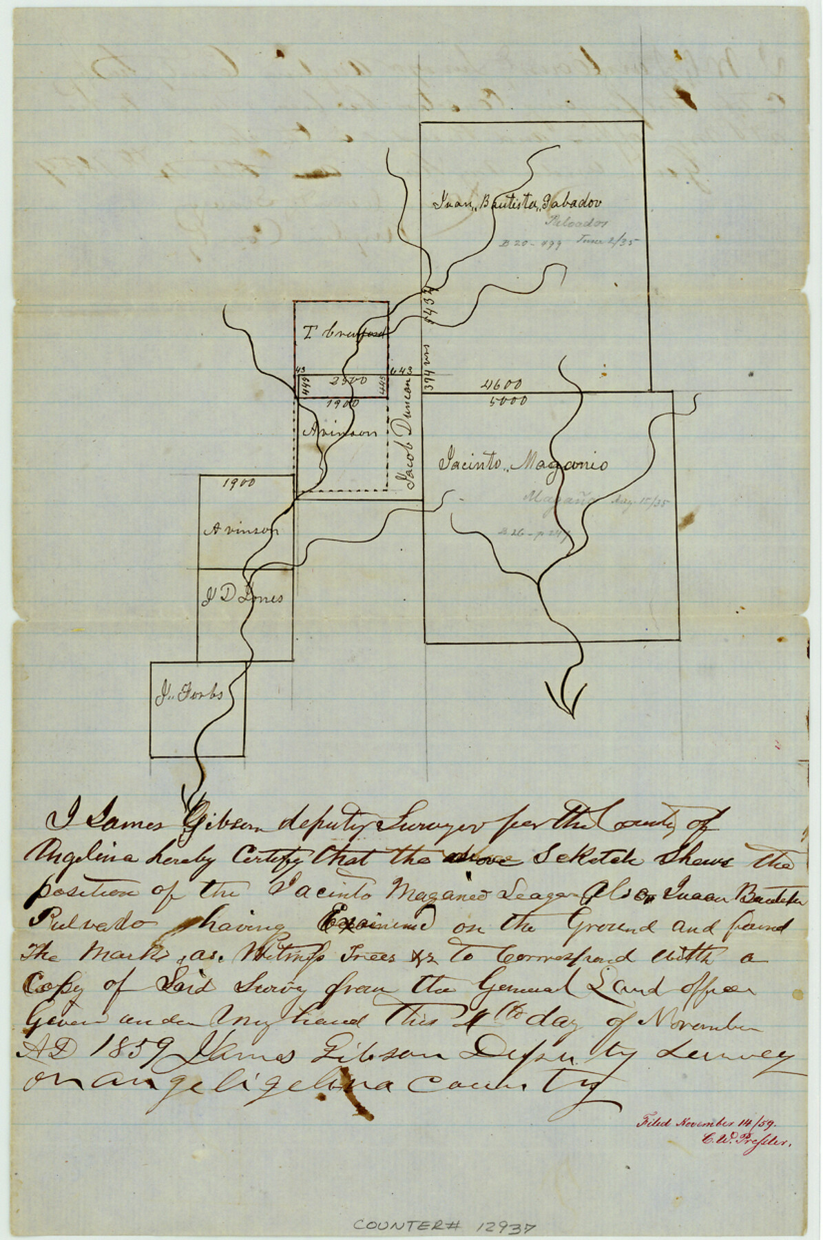
[Sketch of surveys around the Magano league north and west of Lufkin]
-
Map/Doc
12937
-
Collection
General Map Collection
-
Object Dates
1859/11/4 (Creation Date)
1859/8/14 (File Date)
-
People and Organizations
W.G. Lang (Surveyor/Engineer)
-
Counties
Angelina
-
Subjects
Surveying Sketch File
-
Height x Width
12.4 x 8.3 inches
31.5 x 21.1 cm
-
Medium
paper, manuscript
-
Features
[Cedar Creek]
Part of: General Map Collection
Edwards County Rolled Sketch 25

Print $20.00
- Digital $50.00
Edwards County Rolled Sketch 25
1955
Size 30.2 x 35.5 inches
Map/Doc 5811
Hamilton County Working Sketch 35

Print $20.00
- Digital $50.00
Hamilton County Working Sketch 35
Size 26.3 x 19.1 inches
Map/Doc 78286
Rio Grande, North Extension McAllen Sheet

Print $20.00
- Digital $50.00
Rio Grande, North Extension McAllen Sheet
1937
Size 18.5 x 42.1 inches
Map/Doc 65108
Webb County Working Sketch 60

Print $20.00
- Digital $50.00
Webb County Working Sketch 60
1960
Size 43.3 x 47.8 inches
Map/Doc 72426
Foard County Sketch File 8

Print $6.00
- Digital $50.00
Foard County Sketch File 8
Size 10.5 x 11.8 inches
Map/Doc 22810
Flight Mission No. BRE-2P, Frame 106, Nueces County

Print $20.00
- Digital $50.00
Flight Mission No. BRE-2P, Frame 106, Nueces County
1956
Size 18.7 x 22.8 inches
Map/Doc 86791
Guadalupe County Working Sketch 11

Print $40.00
- Digital $50.00
Guadalupe County Working Sketch 11
1972
Size 67.7 x 45.0 inches
Map/Doc 63320
Marion County Rolled Sketch 4

Print $40.00
- Digital $50.00
Marion County Rolled Sketch 4
1951
Size 43.1 x 58.0 inches
Map/Doc 9491
Coke County Sketch File 13

Print $40.00
- Digital $50.00
Coke County Sketch File 13
Size 17.5 x 13.1 inches
Map/Doc 18596
Nueces County NRC Article 33.136 Sketch 2

Print $20.00
- Digital $50.00
Nueces County NRC Article 33.136 Sketch 2
2002
Size 29.3 x 44.4 inches
Map/Doc 61622
Houston County Working Sketch 28

Print $20.00
- Digital $50.00
Houston County Working Sketch 28
1988
Size 30.2 x 37.8 inches
Map/Doc 66258
Glasscock County Sketch File 27

Print $10.00
- Digital $50.00
Glasscock County Sketch File 27
1989
Size 11.3 x 8.8 inches
Map/Doc 24206
You may also like

[Sketch for Mineral Application 36486 and 38244 - Liberty County]
![65621, [Sketch for Mineral Application 36486 and 38244 - Liberty County], General Map Collection](https://historictexasmaps.com/wmedia_w700/maps/65621.tif.jpg)
Print $20.00
- Digital $50.00
[Sketch for Mineral Application 36486 and 38244 - Liberty County]
1976
Size 24.0 x 43.9 inches
Map/Doc 65621
Blanco County Boundary File 10

Print $26.00
- Digital $50.00
Blanco County Boundary File 10
Size 8.9 x 7.6 inches
Map/Doc 50576
Jack County Sketch File 1

Print $4.00
- Digital $50.00
Jack County Sketch File 1
Size 8.4 x 6.4 inches
Map/Doc 27499
McLennan County Boundary File 2

Print $38.00
- Digital $50.00
McLennan County Boundary File 2
Size 10.6 x 7.9 inches
Map/Doc 56948
Flight Mission No. DCL-6C, Frame 30, Kenedy County

Print $20.00
- Digital $50.00
Flight Mission No. DCL-6C, Frame 30, Kenedy County
1943
Size 18.8 x 22.3 inches
Map/Doc 85887
Blanco County Sketch File 16

Print $20.00
- Digital $50.00
Blanco County Sketch File 16
1861
Size 19.9 x 15.8 inches
Map/Doc 10929
[Sketch for Mineral Application 13440]
![2799, [Sketch for Mineral Application 13440], General Map Collection](https://historictexasmaps.com/wmedia_w700/maps/2799-1.tif.jpg)
Print $20.00
- Digital $50.00
[Sketch for Mineral Application 13440]
1925
Size 24.3 x 54.0 inches
Map/Doc 2799
[Lgs. 110-112, 678-680 with ties to County Line]
![90157, [Lgs. 110-112, 678-680 with ties to County Line], Twichell Survey Records](https://historictexasmaps.com/wmedia_w700/maps/90157-1.tif.jpg)
Print $20.00
- Digital $50.00
[Lgs. 110-112, 678-680 with ties to County Line]
Size 37.7 x 22.9 inches
Map/Doc 90157
Crosby County Boundary File 4

Print $88.00
- Digital $50.00
Crosby County Boundary File 4
Size 14.8 x 9.1 inches
Map/Doc 52003
Shackelford County

Print $20.00
- Digital $50.00
Shackelford County
1972
Size 42.8 x 36.3 inches
Map/Doc 73287
Flight Mission No. CUG-1P, Frame 44, Kleberg County

Print $20.00
- Digital $50.00
Flight Mission No. CUG-1P, Frame 44, Kleberg County
1956
Size 18.7 x 22.3 inches
Map/Doc 86122