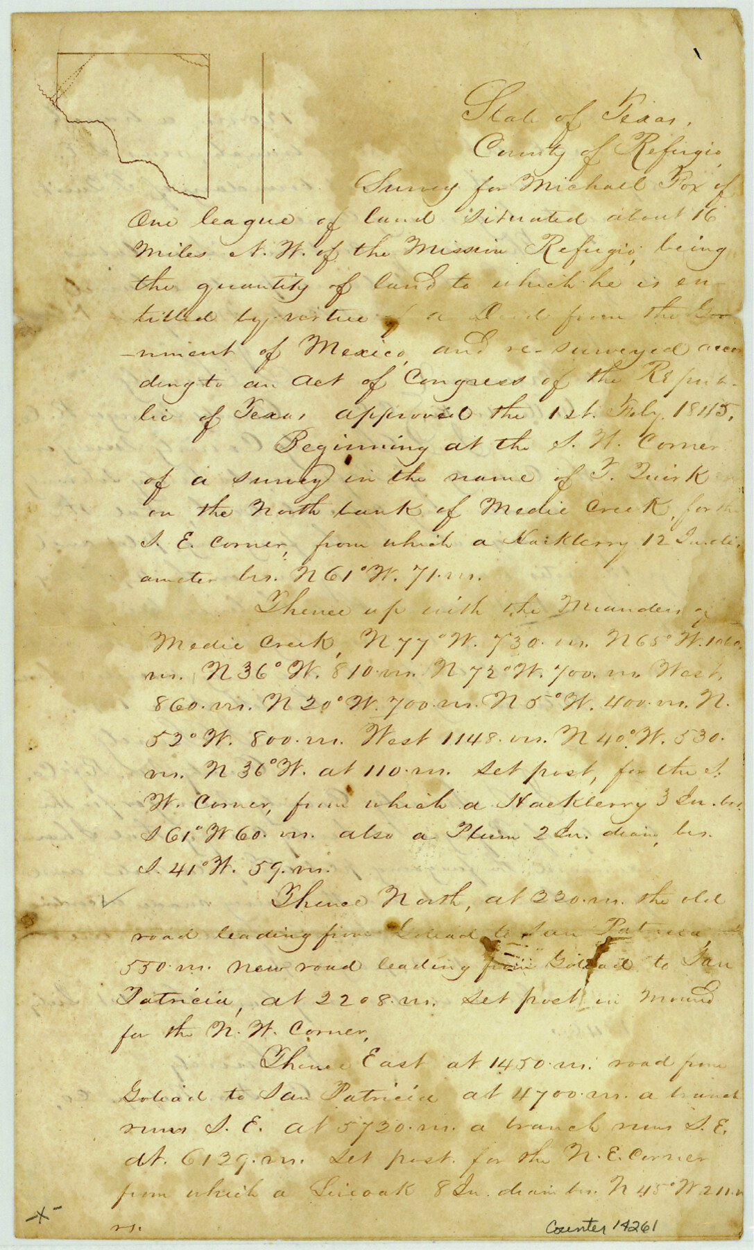
Bee County Sketch File 3
[Field notes of a survey of one league of land made for Michael Fox on Medio Creek]
-
Map/Doc
14261
-
Collection
General Map Collection
-
Object Dates
1846/6/29 (Survey Date)
1846/6/30 (Creation Date)
-
People and Organizations
J. Snively (Surveyor/Engineer)
Luke Freeman (Chainman/Field Personnel)
John Gullemboeski (Chainman/Field Personnel)
-
Counties
Bee
-
Subjects
Surveying Sketch File
-
Height x Width
12.5 x 7.6 inches
31.8 x 19.3 cm
-
Medium
paper, manuscript
-
Features
Media Creek
Goliad to San Patricio Road
Goliad Road
San Patricio Road
Part of: General Map Collection
Flight Mission No. BRA-7M, Frame 122, Jefferson County

Print $20.00
- Digital $50.00
Flight Mission No. BRA-7M, Frame 122, Jefferson County
1953
Size 18.7 x 22.3 inches
Map/Doc 85516
Falls County Sketch File 15

Print $4.00
- Digital $50.00
Falls County Sketch File 15
Size 13.0 x 8.2 inches
Map/Doc 22372
Duval County Sketch File 40a

Print $10.00
- Digital $50.00
Duval County Sketch File 40a
Size 13.9 x 8.8 inches
Map/Doc 21389
Duval County Working Sketch 16

Print $20.00
- Digital $50.00
Duval County Working Sketch 16
1939
Size 14.6 x 25.3 inches
Map/Doc 68729
Presidio County Sketch File 28

Print $20.00
- Digital $50.00
Presidio County Sketch File 28
1890
Size 30.2 x 16.1 inches
Map/Doc 11709

Uvalde County Working Sketch 6

Print $20.00
- Digital $50.00
Uvalde County Working Sketch 6
1940
Size 37.8 x 38.9 inches
Map/Doc 72076
Real County Sketch File 18

Print $28.00
- Digital $50.00
Real County Sketch File 18
1964
Size 14.3 x 8.9 inches
Map/Doc 35076
DeWitt County

Print $40.00
- Digital $50.00
DeWitt County
1987
Size 41.4 x 49.9 inches
Map/Doc 77263
Matagorda County Working Sketch 13

Print $20.00
- Digital $50.00
Matagorda County Working Sketch 13
1949
Size 41.5 x 35.7 inches
Map/Doc 70871
Map showing surveys made on Mustang Island

Print $40.00
- Digital $50.00
Map showing surveys made on Mustang Island
1945
Size 54.7 x 21.0 inches
Map/Doc 2948
Smith County Sketch File 3

Print $4.00
- Digital $50.00
Smith County Sketch File 3
1853
Size 10.5 x 8.6 inches
Map/Doc 36750
You may also like
Clason's Guide Map of Texas

Print $20.00
- Digital $50.00
Clason's Guide Map of Texas
1919
Size 22.4 x 24.5 inches
Map/Doc 97157
Working Sketch in Dickens & King Cos.
Print $20.00
- Digital $50.00
Working Sketch in Dickens & King Cos.
Size 24.4 x 20.4 inches
Map/Doc 10770
Lamar County State Real Property Sketch 1

Print $40.00
- Digital $50.00
Lamar County State Real Property Sketch 1
2013
Size 48.0 x 36.0 inches
Map/Doc 93655
Map of the District of San Patricio and Nueces

Print $40.00
- Digital $50.00
Map of the District of San Patricio and Nueces
Size 93.8 x 67.5 inches
Map/Doc 1955
Gulf Coast of the United States, Key West to Rio Grande

Print $20.00
- Digital $50.00
Gulf Coast of the United States, Key West to Rio Grande
1892
Size 27.3 x 18.3 inches
Map/Doc 72671
Freestone County Working Sketch 3

Print $20.00
- Digital $50.00
Freestone County Working Sketch 3
1914
Size 18.8 x 16.2 inches
Map/Doc 69245
Starr County Rolled Sketch 35

Print $20.00
- Digital $50.00
Starr County Rolled Sketch 35
1925
Size 40.1 x 12.8 inches
Map/Doc 7832
Map of Block "C" of J. E. and J. W. Rhea's Ranch situated in Parmer Co., Texas

Print $20.00
- Digital $50.00
Map of Block "C" of J. E. and J. W. Rhea's Ranch situated in Parmer Co., Texas
1905
Size 13.5 x 25.4 inches
Map/Doc 91600
Chambers County Working Sketch 11

Print $20.00
- Digital $50.00
Chambers County Working Sketch 11
1952
Size 40.6 x 26.7 inches
Map/Doc 67994
Brewster County Rolled Sketch 91

Print $20.00
- Digital $50.00
Brewster County Rolled Sketch 91
1949
Size 27.5 x 15.3 inches
Map/Doc 5249
Flight Mission No. DQO-11K, Frame 18, Galveston County

Print $20.00
- Digital $50.00
Flight Mission No. DQO-11K, Frame 18, Galveston County
1952
Size 18.7 x 22.4 inches
Map/Doc 85211
Blanco County Rolled Sketch 23

Print $20.00
- Digital $50.00
Blanco County Rolled Sketch 23
2019
Size 24.1 x 35.7 inches
Map/Doc 97346