Brewster County Sketch File FN-35
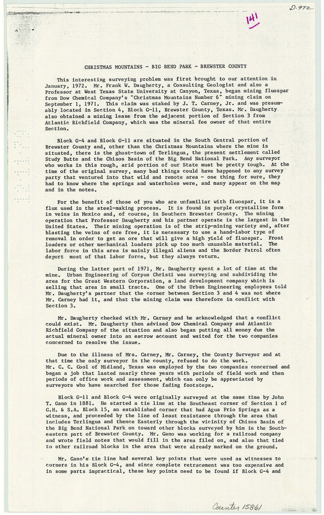
Christmas Mountains - Big Bend Park - Brewster County [report about Dow Chemical fluospar mining claim in section 4, Block G-11]
-
Map/Doc
15861
-
Collection
General Map Collection
-
Object Dates
1979/2/13 (Creation Date)
1979/12/11 (File Date)
-
People and Organizations
C.B. Thomas (Surveyor/Engineer)
-
Counties
Brewster
-
Subjects
Surveying Sketch File
-
Height x Width
14.2 x 8.9 inches
36.1 x 22.6 cm
-
Medium
paper, photocopy
-
Features
Christmas Mountains
Terlingua
Study Butte
Chisos Basin
Big Bend National Park
Sulphur Springs
Gano Springs
Part of: General Map Collection
[Map of Clay County]
![3402, [Map of Clay County], General Map Collection](https://historictexasmaps.com/wmedia_w700/maps/3402-1.tif.jpg)
Print $20.00
- Digital $50.00
[Map of Clay County]
1860
Size 28.3 x 19.1 inches
Map/Doc 3402
L'Amerique Meridionale, et Septentrionale Dressee selon les derniers Relations et suivant les Nouvelles Decouvertes

Print $20.00
- Digital $50.00
L'Amerique Meridionale, et Septentrionale Dressee selon les derniers Relations et suivant les Nouvelles Decouvertes
1726
Size 18.9 x 24.1 inches
Map/Doc 95134
Kimble County Sketch File 38

Print $10.00
- Digital $50.00
Kimble County Sketch File 38
1989
Size 3.6 x 4.0 inches
Map/Doc 28992
Erath County Working Sketch 7

Print $20.00
- Digital $50.00
Erath County Working Sketch 7
1921
Size 15.8 x 16.1 inches
Map/Doc 69088
McMullen County Working Sketch 26

Print $20.00
- Digital $50.00
McMullen County Working Sketch 26
1953
Size 17.8 x 14.5 inches
Map/Doc 70727
Wilson County

Print $40.00
- Digital $50.00
Wilson County
1921
Size 39.9 x 48.8 inches
Map/Doc 95677
Henderson County Sketch File 12

Print $8.00
- Digital $50.00
Henderson County Sketch File 12
1871
Size 8.4 x 7.4 inches
Map/Doc 26349
Brazoria County Rolled Sketch 50A

Print $20.00
- Digital $50.00
Brazoria County Rolled Sketch 50A
1932
Size 17.8 x 26.1 inches
Map/Doc 5188
Pecos County Working Sketch 15

Print $20.00
- Digital $50.00
Pecos County Working Sketch 15
1914
Size 29.8 x 15.4 inches
Map/Doc 71485
Map of the State of Texas from the Latest Authorities

Print $20.00
- Digital $50.00
Map of the State of Texas from the Latest Authorities
1853
Size 14.2 x 17.4 inches
Map/Doc 89221
Pecos County Rolled Sketch 51

Print $20.00
- Digital $50.00
Pecos County Rolled Sketch 51
1914
Size 8.6 x 35.5 inches
Map/Doc 7227
Atascosa County Working Sketch 31

Print $20.00
- Digital $50.00
Atascosa County Working Sketch 31
1981
Size 21.4 x 16.6 inches
Map/Doc 67227
You may also like
Nueces County Rolled Sketch 26

Print $40.00
- Digital $50.00
Nueces County Rolled Sketch 26
1945
Size 24.3 x 122.6 inches
Map/Doc 9595
Jim Wells Co.

Print $20.00
- Digital $50.00
Jim Wells Co.
1913
Size 43.1 x 21.4 inches
Map/Doc 66886
Sectional Map No. 3 of the lands and of the line of the Texas & Pacific Ry. Co. in Reeves and parts of Tom Green, Pecos, Presidio & El Paso Cos.

Print $20.00
- Digital $50.00
Sectional Map No. 3 of the lands and of the line of the Texas & Pacific Ry. Co. in Reeves and parts of Tom Green, Pecos, Presidio & El Paso Cos.
1885
Size 24.2 x 18.9 inches
Map/Doc 4858
Hays County Sketch File 25a

Print $2.00
- Digital $50.00
Hays County Sketch File 25a
1881
Size 10.2 x 8.0 inches
Map/Doc 26251
Flight Mission No. DQO-11K, Frame 19, Galveston County

Print $20.00
- Digital $50.00
Flight Mission No. DQO-11K, Frame 19, Galveston County
1952
Size 18.6 x 22.4 inches
Map/Doc 85213
Crockett County Sketch File 42

Print $28.00
- Digital $50.00
Crockett County Sketch File 42
Size 12.8 x 8.4 inches
Map/Doc 19755
Flight Mission No. BQR-20K, Frame 7, Brazoria County

Print $20.00
- Digital $50.00
Flight Mission No. BQR-20K, Frame 7, Brazoria County
1952
Size 18.6 x 22.4 inches
Map/Doc 84109
Rio Grande, Run Sheet

Print $2.00
- Digital $50.00
Rio Grande, Run Sheet
1931
Size 17.0 x 14.3 inches
Map/Doc 65120
Llano County Sketch File 7

Print $4.00
- Digital $50.00
Llano County Sketch File 7
Size 6.6 x 7.3 inches
Map/Doc 30362
Flight Mission No. CZW-2R, Frame 27, Hardeman County

Print $20.00
- Digital $50.00
Flight Mission No. CZW-2R, Frame 27, Hardeman County
1956
Size 18.8 x 22.4 inches
Map/Doc 85238
Approaches to Galveston Bay

Print $40.00
- Digital $50.00
Approaches to Galveston Bay
1986
Size 36.8 x 54.8 inches
Map/Doc 69886
[Sketch showing Block M-3]
![91707, [Sketch showing Block M-3], Twichell Survey Records](https://historictexasmaps.com/wmedia_w700/maps/91707-1.tif.jpg)
Print $2.00
- Digital $50.00
[Sketch showing Block M-3]
Size 14.4 x 6.6 inches
Map/Doc 91707