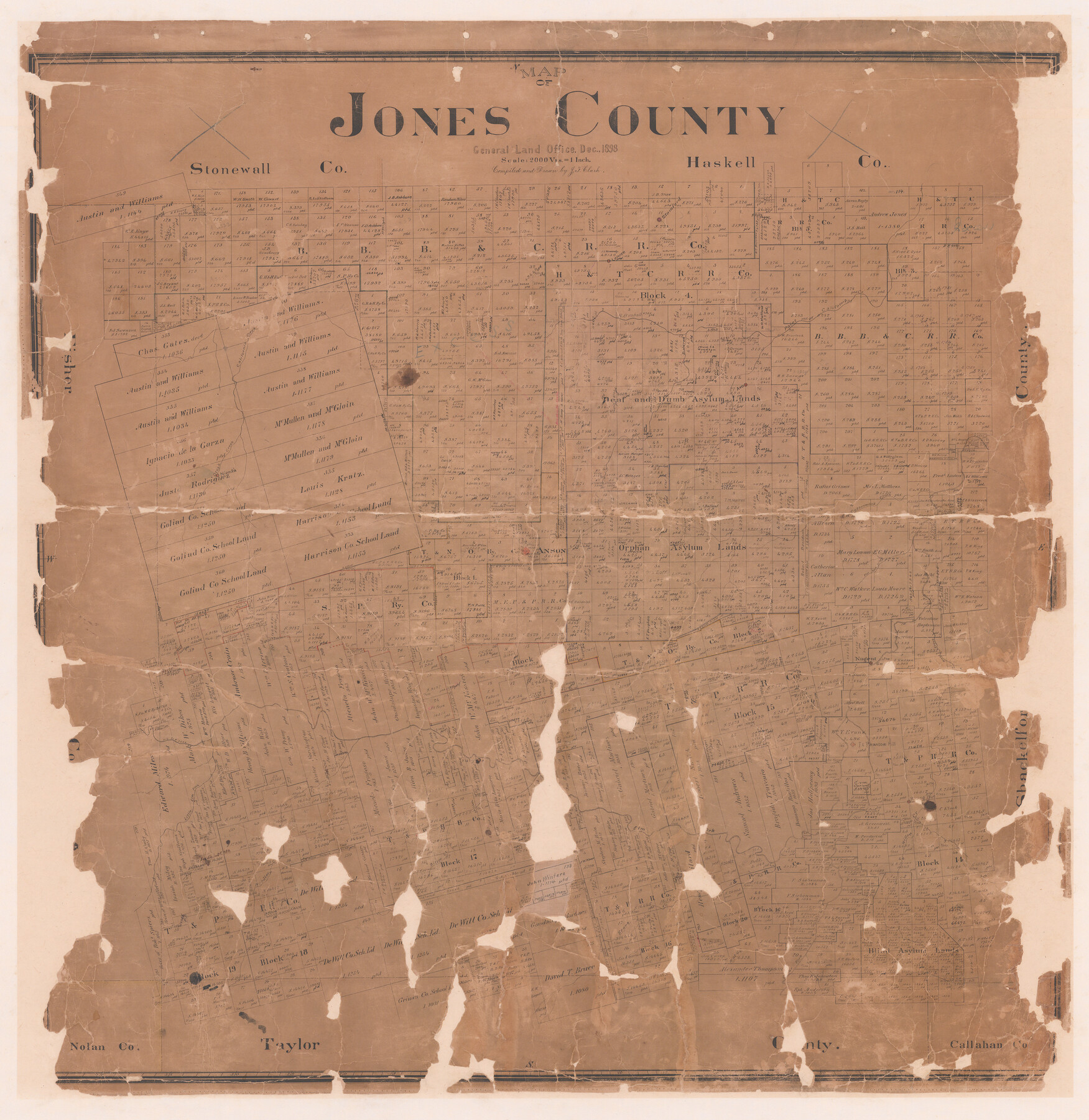
Map of Jones County
-
Map/Doc
16862
-
Collection
General Map Collection
-
Object Dates
1898 (Creation Date)
-
People and Organizations
Texas General Land Office (Publisher)
J.F. Clark (Compiler)
J.F. Clark (Draftsman)
-
Counties
Jones
-
Subjects
County
-
Height x Width
41.2 x 40.0 inches
104.6 x 101.6 cm
-
Medium
paper, manuscript
-
Features
Big Elm Fork
Rising Sun
Flat Rock Creek
Evans Creek
Clear Fork
TCRR
Bitter Creek
Noodle Creek
Elm Fork
Willow Creek
Fort Phantomhill [sic]
Truby
Little Elm Fork
Lenore
Nugent
Dead Man's Creek
Fort Phantomhill [sic]
Anson
Otey's Creek
Nienda
Cottonwood Creek
Avo
California Creek
Paint Creek
Stamford
Part of: General Map Collection
Schleicher County Sketch File 33

Print $8.00
- Digital $50.00
Schleicher County Sketch File 33
1948
Size 11.3 x 8.9 inches
Map/Doc 36534
Hutchinson County Working Sketch 22

Print $40.00
- Digital $50.00
Hutchinson County Working Sketch 22
1966
Size 67.9 x 35.5 inches
Map/Doc 66382
Dawson County Sketch File 1

Print $6.00
- Digital $50.00
Dawson County Sketch File 1
Size 7.5 x 3.9 inches
Map/Doc 20495
Flight Mission No. DIX-7P, Frame 24, Aransas County

Print $20.00
- Digital $50.00
Flight Mission No. DIX-7P, Frame 24, Aransas County
1956
Size 18.6 x 22.6 inches
Map/Doc 83876
Fort Bend County Boundary File 2

Print $8.00
- Digital $50.00
Fort Bend County Boundary File 2
Size 14.3 x 8.9 inches
Map/Doc 53559
Flight Mission No. CRC-4R, Frame 172, Chambers County

Print $20.00
- Digital $50.00
Flight Mission No. CRC-4R, Frame 172, Chambers County
1956
Size 18.6 x 22.3 inches
Map/Doc 84923
Flight Mission No. DAG-21K, Frame 129, Matagorda County

Print $20.00
- Digital $50.00
Flight Mission No. DAG-21K, Frame 129, Matagorda County
1952
Size 18.6 x 22.5 inches
Map/Doc 86455
Schleicher County Sketch File 48

Print $4.00
- Digital $50.00
Schleicher County Sketch File 48
1953
Size 11.2 x 8.7 inches
Map/Doc 36558
Liberty County Working Sketch 56

Print $40.00
- Digital $50.00
Liberty County Working Sketch 56
1966
Size 52.0 x 28.4 inches
Map/Doc 70516
Montague County Working Sketch 36

Print $20.00
- Digital $50.00
Montague County Working Sketch 36
1980
Size 38.4 x 45.1 inches
Map/Doc 71102
Concho County Working Sketch 25

Print $20.00
- Digital $50.00
Concho County Working Sketch 25
1982
Size 32.3 x 38.1 inches
Map/Doc 68207
[Sketch for Mineral Application 24072, San Jacinto River]
![65587, [Sketch for Mineral Application 24072, San Jacinto River], General Map Collection](https://historictexasmaps.com/wmedia_w700/maps/65587.tif.jpg)
Print $20.00
- Digital $50.00
[Sketch for Mineral Application 24072, San Jacinto River]
1929
Size 19.3 x 16.4 inches
Map/Doc 65587
You may also like

[Gulf, Colorado & Santa Fe]
![64574, [Gulf, Colorado & Santa Fe], General Map Collection](https://historictexasmaps.com/wmedia_w700/maps/64574.tif.jpg)
Print $40.00
- Digital $50.00
[Gulf, Colorado & Santa Fe]
Size 32.8 x 126.0 inches
Map/Doc 64574
Bosque County Sketch File 11

Print $4.00
- Digital $50.00
Bosque County Sketch File 11
1863
Size 10.2 x 8.3 inches
Map/Doc 14759
Real County Rolled Sketch 18

Print $20.00
- Digital $50.00
Real County Rolled Sketch 18
Size 18.5 x 24.3 inches
Map/Doc 7462
Zavala County Sketch File 17

Print $64.00
- Digital $50.00
Zavala County Sketch File 17
1900
Size 9.1 x 10.1 inches
Map/Doc 41324
Flight Mission No. BRA-8M, Frame 71, Jefferson County

Print $20.00
- Digital $50.00
Flight Mission No. BRA-8M, Frame 71, Jefferson County
1953
Size 18.7 x 22.3 inches
Map/Doc 85591
Upton County Working Sketch 34

Print $40.00
- Digital $50.00
Upton County Working Sketch 34
1956
Size 29.6 x 49.1 inches
Map/Doc 69530
Webb County Working Sketch Graphic Index - northwest part

Print $40.00
- Digital $50.00
Webb County Working Sketch Graphic Index - northwest part
1984
Size 42.1 x 51.6 inches
Map/Doc 76736
Presidio County Working Sketch 104

Print $20.00
- Digital $50.00
Presidio County Working Sketch 104
1980
Size 39.7 x 36.0 inches
Map/Doc 71781
Map of Concho County

Print $20.00
- Digital $50.00
Map of Concho County
1879
Size 25.1 x 18.4 inches
Map/Doc 3436
Duval County Sketch File 45b

Print $40.00
- Digital $50.00
Duval County Sketch File 45b
1936
Size 26.0 x 18.1 inches
Map/Doc 11399
Leon County Texas

Print $20.00
- Digital $50.00
Leon County Texas
1896
Size 25.4 x 22.1 inches
Map/Doc 3806