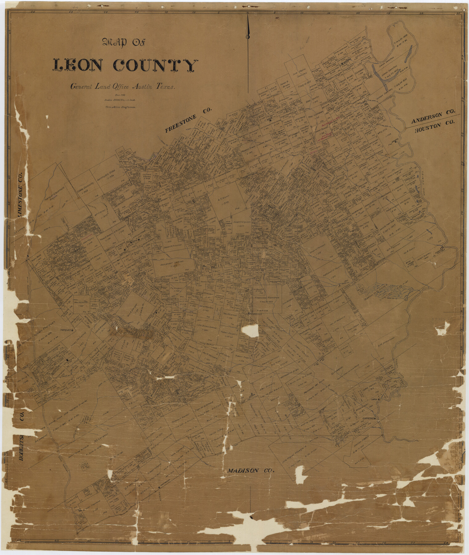
Map of Leon County
-
Map/Doc
16877
-
Collection
General Map Collection
-
Object Dates
1916 (Creation Date)
-
People and Organizations
Texas General Land Office (Publisher)
Tom G. Atlee (Compiler)
Tom G. Atlee (Draftsman)
-
Counties
Leon
-
Subjects
County
-
Height x Width
48.4 x 40.8 inches
122.9 x 103.6 cm
-
Comments
Conservation funded in 2002 with donation from Guaranty Title Company of Leon County.
-
Features
Clear Creek
Branch [of Lower Keechi Creek]
Nancy Branch [of Birch Creek]
Kechi Creek
Mill
Beaver Creek
Centerville
Keechi Trace
Robbins
Marquez
Spring Creek
[ ]ver Creek
Boggy Bayou
Brushy Creek
Red Oak Creek
Buck Creek
Lower Keechi Creek
Forky Deer Creek
Boggy Creek
Yellow Branch [of Boggy Creek]
Cairo
Leona
Flynn
Rogers Creek
6 Mile Creek
Commerce
San Antonio Nacogdoches Road
San Antonio Road
Nacogdoches Road
Copeland Creek
Navasota River
Normangee
Wheelock Creek
Kechi
I&GN
H&TC
Twin Branch [of Keechi Creek]
Ringgolds Creek
North West Fork of Boons Creek
South West Fork of Boons Creek
Navarro
Keechi Creek
Mustang Creek
North Prong of Buffalo Creek
Buffalo Creek
Silver Creek
Alligator Creek
Bliss Branch [of Buffalo Creek]
Oakwoods
Birch Creek
Trinity River
Resaca Creek
Lamb's Creek
TR&BRV
Panther Branch [of Alligator Creek]
North Creek
Mine Creek
Jewett
Ett
Kikapoo [sic] Village
Pine Creek
Beaver Dam Creek
Cottonwood Creek
Part of: General Map Collection
Cass County Rolled Sketch BRR

Print $40.00
- Digital $50.00
Cass County Rolled Sketch BRR
1936
Size 67.3 x 28.0 inches
Map/Doc 8581
Brazos River, Millican Sheet

Print $6.00
- Digital $50.00
Brazos River, Millican Sheet
1936
Size 30.1 x 31.6 inches
Map/Doc 65278
Kinney County Working Sketch 20

Print $20.00
- Digital $50.00
Kinney County Working Sketch 20
1948
Size 31.3 x 24.3 inches
Map/Doc 70202
Childress County Sketch File 23

Print $4.00
- Digital $50.00
Childress County Sketch File 23
1892
Size 10.9 x 8.7 inches
Map/Doc 18382
Parker County Working Sketch 10

Print $20.00
- Digital $50.00
Parker County Working Sketch 10
1969
Map/Doc 71460

Presidio County Rolled Sketch 57

Print $20.00
- Digital $50.00
Presidio County Rolled Sketch 57
1915
Size 22.8 x 17.3 inches
Map/Doc 7350
Flight Mission No. DCL-7C, Frame 138, Kenedy County

Print $20.00
- Digital $50.00
Flight Mission No. DCL-7C, Frame 138, Kenedy County
1943
Size 18.6 x 22.3 inches
Map/Doc 86095
Bastrop County

Print $40.00
- Digital $50.00
Bastrop County
1917
Size 49.7 x 42.0 inches
Map/Doc 4796
Trinity County Working Sketch 20

Print $20.00
- Digital $50.00
Trinity County Working Sketch 20
Size 25.9 x 29.7 inches
Map/Doc 69469
Flight Mission No. DAG-18K, Frame 188, Matagorda County

Print $20.00
- Digital $50.00
Flight Mission No. DAG-18K, Frame 188, Matagorda County
1952
Size 18.6 x 22.3 inches
Map/Doc 86380
Kent County Working Sketch 3a

Print $20.00
- Digital $50.00
Kent County Working Sketch 3a
1948
Size 24.5 x 18.6 inches
Map/Doc 70009
You may also like
Howard County Boundary File 2a

Print $9.00
- Digital $50.00
Howard County Boundary File 2a
Size 14.6 x 11.3 inches
Map/Doc 55118
Flight Mission No. CRC-3R, Frame 166, Chambers County

Print $20.00
- Digital $50.00
Flight Mission No. CRC-3R, Frame 166, Chambers County
1956
Size 18.8 x 22.4 inches
Map/Doc 84848
Red River County Working Sketch 43

Print $40.00
- Digital $50.00
Red River County Working Sketch 43
1968
Size 72.5 x 36.8 inches
Map/Doc 72026
Caldwell County Sketch File 1

Print $22.00
- Digital $50.00
Caldwell County Sketch File 1
Size 8.6 x 12.4 inches
Map/Doc 35825
Bee County Working Sketch 24

Print $20.00
- Digital $50.00
Bee County Working Sketch 24
1987
Size 36.6 x 24.0 inches
Map/Doc 67274
Smith County Working Sketch 17

Print $20.00
- Digital $50.00
Smith County Working Sketch 17
1994
Size 24.6 x 24.2 inches
Map/Doc 63902
Mitchell County Rolled Sketch 4

Print $20.00
- Digital $50.00
Mitchell County Rolled Sketch 4
Size 32.6 x 41.4 inches
Map/Doc 6785
Flight Mission No. CRK-3P, Frame 128, Refugio County

Print $20.00
- Digital $50.00
Flight Mission No. CRK-3P, Frame 128, Refugio County
1956
Size 18.6 x 22.4 inches
Map/Doc 86916
Andrews County Rolled Sketch 37

Print $20.00
- Digital $50.00
Andrews County Rolled Sketch 37
Size 29.1 x 19.8 inches
Map/Doc 77179
[Blueprint of unknown Block/Surveys]
![92139, [Blueprint of unknown Block/Surveys], Twichell Survey Records](https://historictexasmaps.com/wmedia_w700/maps/92139-1.tif.jpg)
Print $20.00
- Digital $50.00
[Blueprint of unknown Block/Surveys]
Size 24.7 x 26.8 inches
Map/Doc 92139
Sherman County Rolled Sketch 13

Print $20.00
- Digital $50.00
Sherman County Rolled Sketch 13
1951
Size 14.3 x 30.7 inches
Map/Doc 7791
Jasper County Working Sketch 16

Print $20.00
- Digital $50.00
Jasper County Working Sketch 16
1928
Size 13.7 x 14.3 inches
Map/Doc 66478