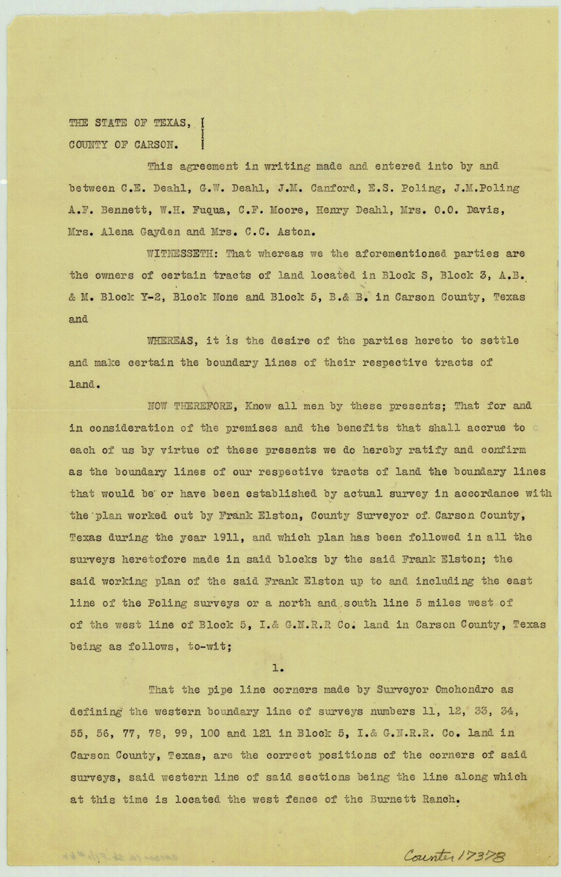
Carson County Sketch File 6b
[Agreement for boundary survey for area in Block Y-2 in northwest part of the county]
-
Map/Doc
17378
-
Collection
General Map Collection
-
Object Dates
1928/12/4 (Creation Date)
1930/3/4 (File Date)
-
Counties
Carson
-
Subjects
Surveying Sketch File
-
Height x Width
13.4 x 8.6 inches
34.0 x 21.8 cm
-
Medium
paper, print
Part of: General Map Collection
General Chart of the Coast No. XXI Gulf Coast from Galveston to the Rio Grande

Print $20.00
- Digital $50.00
General Chart of the Coast No. XXI Gulf Coast from Galveston to the Rio Grande
1883
Size 27.1 x 18.2 inches
Map/Doc 72730
Map of Colorado County

Print $20.00
- Digital $50.00
Map of Colorado County
1841
Size 27.6 x 36.9 inches
Map/Doc 3422
Travis County State Real Property Sketch 16

Print $20.00
- Digital $50.00
Travis County State Real Property Sketch 16
2009
Size 48.1 x 36.1 inches
Map/Doc 90086
Crockett County Working Sketch 69

Print $20.00
- Digital $50.00
Crockett County Working Sketch 69
1962
Size 34.8 x 45.5 inches
Map/Doc 68402
Brazoria County NRC Article 33.136 Sketch 34

Print $24.00
Brazoria County NRC Article 33.136 Sketch 34
2025
Map/Doc 97478
Atascosa County Rolled Sketch 11

Print $20.00
- Digital $50.00
Atascosa County Rolled Sketch 11
1943
Size 22.8 x 38.0 inches
Map/Doc 5094
Wharton County Working Sketch 2

Print $20.00
- Digital $50.00
Wharton County Working Sketch 2
Size 29.3 x 37.3 inches
Map/Doc 72466
Presidio County Working Sketch 131

Print $40.00
- Digital $50.00
Presidio County Working Sketch 131
1989
Size 43.5 x 50.4 inches
Map/Doc 71809
Stonewall County Working Sketch 4

Print $20.00
- Digital $50.00
Stonewall County Working Sketch 4
1919
Size 28.7 x 23.8 inches
Map/Doc 63998
Cass County Working Sketch 35

Print $20.00
- Digital $50.00
Cass County Working Sketch 35
1982
Size 23.5 x 44.8 inches
Map/Doc 67938
Jefferson County Rolled Sketch 60

Print $20.00
- Digital $50.00
Jefferson County Rolled Sketch 60
1885
Size 34.0 x 35.9 inches
Map/Doc 9316
Val Verde County Sketch File 7

Print $6.00
- Digital $50.00
Val Verde County Sketch File 7
1877
Size 16.9 x 9.7 inches
Map/Doc 39196
You may also like
Map showing survey for proposed ship channel from Brownsville to Brazos Santiago Pass

Print $20.00
- Digital $50.00
Map showing survey for proposed ship channel from Brownsville to Brazos Santiago Pass
1912
Size 18.4 x 28.8 inches
Map/Doc 72903
Jasper County Working Sketch 9

Print $20.00
- Digital $50.00
Jasper County Working Sketch 9
1917
Size 21.0 x 14.3 inches
Map/Doc 66471
[Texas & Pacific RR. Co. Blocks 6 and 4, L. C. Denison, Guadalupe College and vicinity]
![92133, [Texas & Pacific RR. Co. Blocks 6 and 4, L. C. Denison, Guadalupe College and vicinity], Twichell Survey Records](https://historictexasmaps.com/wmedia_w700/maps/92133-1.tif.jpg)
Print $20.00
- Digital $50.00
[Texas & Pacific RR. Co. Blocks 6 and 4, L. C. Denison, Guadalupe College and vicinity]
Size 32.5 x 19.8 inches
Map/Doc 92133
Zapata County Working Sketch 9

Print $20.00
- Digital $50.00
Zapata County Working Sketch 9
1951
Size 34.9 x 18.1 inches
Map/Doc 62060
Webb County Rolled Sketch 22

Print $40.00
- Digital $50.00
Webb County Rolled Sketch 22
Size 108.0 x 43.7 inches
Map/Doc 10120
Geographical, Statistical, and Historical Map of Mexico

Print $20.00
- Digital $50.00
Geographical, Statistical, and Historical Map of Mexico
1822
Size 18.0 x 22.4 inches
Map/Doc 95694
Jeff Davis County Working Sketch 24

Print $40.00
- Digital $50.00
Jeff Davis County Working Sketch 24
1958
Size 24.9 x 52.9 inches
Map/Doc 66519
Shelby County Shelby District

Print $20.00
- Digital $50.00
Shelby County Shelby District
1880
Size 20.5 x 25.3 inches
Map/Doc 4030
Flight Mission No. DQO-12K, Frame 35, Galveston County

Print $20.00
- Digital $50.00
Flight Mission No. DQO-12K, Frame 35, Galveston County
1952
Size 18.7 x 22.4 inches
Map/Doc 85226
Ochiltree County Boundary File 1a

Print $4.00
- Digital $50.00
Ochiltree County Boundary File 1a
Size 11.0 x 8.5 inches
Map/Doc 57664

[H. & G. N. Block 28]
![90344, [H. & G. N. Block 28], Twichell Survey Records](https://historictexasmaps.com/wmedia_w700/maps/90344-1.tif.jpg)
Print $20.00
- Digital $50.00
[H. & G. N. Block 28]
Size 25.1 x 31.2 inches
Map/Doc 90344