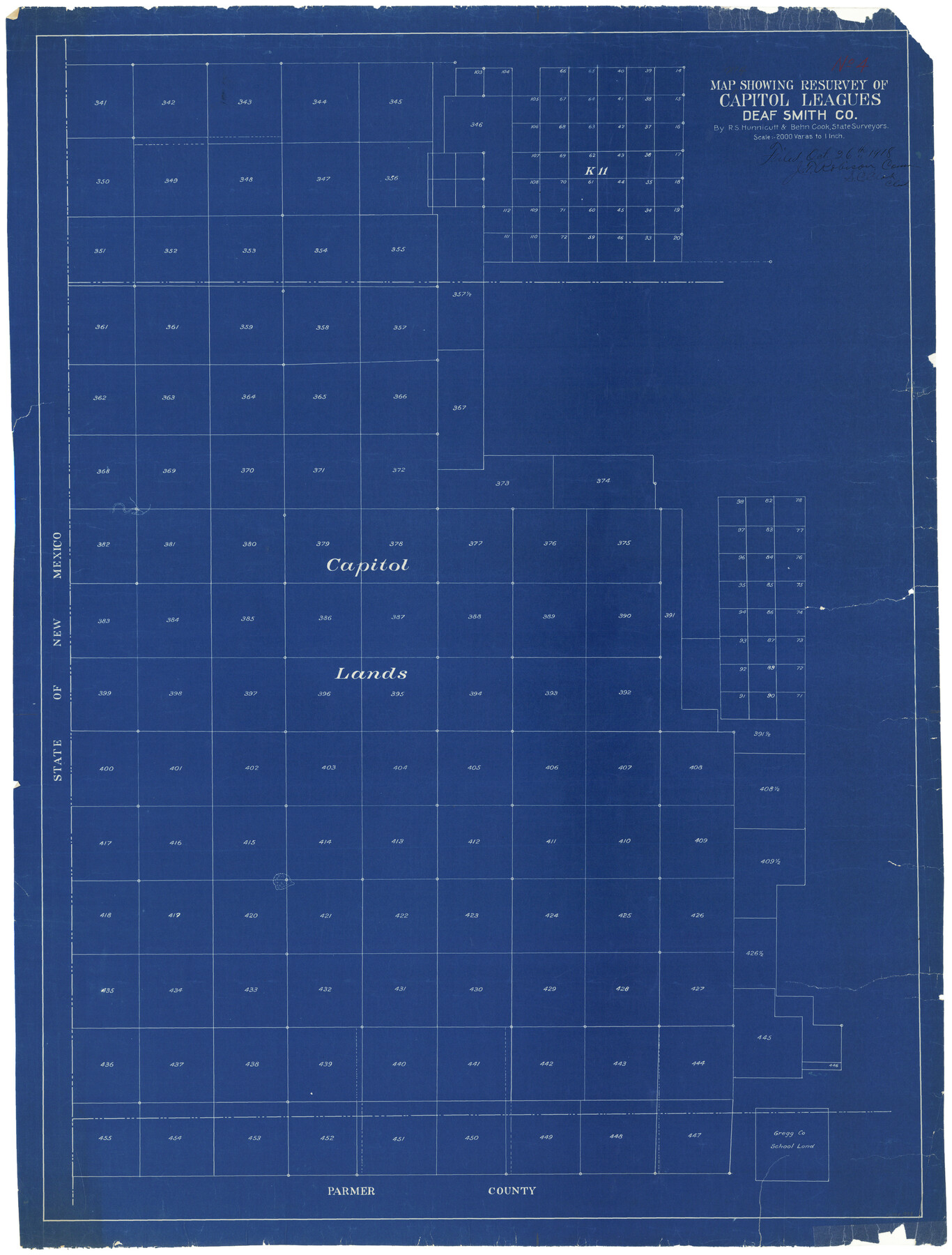
Map Showing Resurvey of Capitol Leagues, Deaf Smith Co.
N-2-40
-
Map/Doc
1756
-
Collection
General Map Collection
-
Object Dates
1918 (Creation Date)
10/26/1918 (File Date)
-
People and Organizations
Behn Cook (Surveyor/Engineer)
R.S. Hunnicut (Surveyor/Engineer)
-
Counties
Deaf Smith
-
Height x Width
42.5 x 31.9 inches
108.0 x 81.0 cm
Part of: General Map Collection
Shelby County Sketch File 32

Print $20.00
- Digital $50.00
Shelby County Sketch File 32
1949
Size 23.4 x 17.7 inches
Map/Doc 12321
Nueces County Sketch File 22

Print $20.00
- Digital $50.00
Nueces County Sketch File 22
Size 19.0 x 31.0 inches
Map/Doc 42181
Edwards County Working Sketch 102

Print $20.00
- Digital $50.00
Edwards County Working Sketch 102
1971
Size 35.0 x 25.5 inches
Map/Doc 68978
Ellis County Sketch File 4

Print $4.00
- Digital $50.00
Ellis County Sketch File 4
1859
Size 13.0 x 8.5 inches
Map/Doc 21832
Jasper County Sketch File 7

Print $22.00
- Digital $50.00
Jasper County Sketch File 7
Size 12.4 x 15.4 inches
Map/Doc 27775
Andrews County

Print $40.00
- Digital $50.00
Andrews County
1951
Size 42.7 x 54.5 inches
Map/Doc 1769
Brazos River, Brazos River Sheet 4

Print $20.00
- Digital $50.00
Brazos River, Brazos River Sheet 4
1926
Size 19.4 x 32.1 inches
Map/Doc 69668
Motley County Working Sketch 11

Print $20.00
- Digital $50.00
Motley County Working Sketch 11
1989
Size 28.5 x 33.0 inches
Map/Doc 71216
Nueces County Working Sketch 2

Print $20.00
- Digital $50.00
Nueces County Working Sketch 2
1950
Size 42.0 x 15.5 inches
Map/Doc 71304
[Surveys in the Travis District along the Colorado River]
![3180, [Surveys in the Travis District along the Colorado River], General Map Collection](https://historictexasmaps.com/wmedia_w700/maps/3180.tif.jpg)
Print $2.00
- Digital $50.00
[Surveys in the Travis District along the Colorado River]
1841
Size 7.0 x 7.3 inches
Map/Doc 3180
Andrews County Rolled Sketch 11

Print $20.00
- Digital $50.00
Andrews County Rolled Sketch 11
1933
Size 28.0 x 37.7 inches
Map/Doc 77161
A Pocket Guide to Austin, Texas - Area Map and Downtown Map

A Pocket Guide to Austin, Texas - Area Map and Downtown Map
Size 17.0 x 20.1 inches
Map/Doc 94385
You may also like
Maverick County Working Sketch 3

Print $20.00
- Digital $50.00
Maverick County Working Sketch 3
1939
Size 34.4 x 24.8 inches
Map/Doc 70895
Map showing those portions of Texas traversed by Rock Island Lines and connections

Print $20.00
- Digital $50.00
Map showing those portions of Texas traversed by Rock Island Lines and connections
1904
Size 15.6 x 12.2 inches
Map/Doc 96588
Stephens County Sketch File 10c

Print $6.00
- Digital $50.00
Stephens County Sketch File 10c
Size 7.8 x 11.5 inches
Map/Doc 37052
Controlled Mosaic by Jack Amman Photogrammetric Engineers, Inc - Sheet 5

Print $20.00
- Digital $50.00
Controlled Mosaic by Jack Amman Photogrammetric Engineers, Inc - Sheet 5
1954
Size 20.8 x 24.0 inches
Map/Doc 83449
Presidio County Rolled Sketch 4

Print $2.00
- Digital $50.00
Presidio County Rolled Sketch 4
Size 10.1 x 6.3 inches
Map/Doc 75984
Sterling County Rolled Sketch 36

Print $20.00
- Digital $50.00
Sterling County Rolled Sketch 36
Size 24.2 x 38.0 inches
Map/Doc 7860
[Map of Block 97, Borden and Scurry Co (Exhibit A); Map of Southeastern part of Young Territory; Map of part of of Borden, Fisher, Kent, Mitchell, Scurry and Garza Cos. Showing the north boundary line of the T&P 80 mile reservation]
![65692, [Map of Block 97, Borden and Scurry Co (Exhibit A); Map of Southeastern part of Young Territory; Map of part of of Borden, Fisher, Kent, Mitchell, Scurry and Garza Cos. Showing the north boundary line of the T&P 80 mile reservation], General Map Collection](https://historictexasmaps.com/wmedia_w700/maps/65692-1.tif.jpg)
Print $20.00
- Digital $50.00
[Map of Block 97, Borden and Scurry Co (Exhibit A); Map of Southeastern part of Young Territory; Map of part of of Borden, Fisher, Kent, Mitchell, Scurry and Garza Cos. Showing the north boundary line of the T&P 80 mile reservation]
1873
Size 33.4 x 29.6 inches
Map/Doc 65692
[Blocks 34 and 35, Township 4N]
![92030, [Blocks 34 and 35, Township 4N], Twichell Survey Records](https://historictexasmaps.com/wmedia_w700/maps/92030-1.tif.jpg)
Print $20.00
- Digital $50.00
[Blocks 34 and 35, Township 4N]
Size 24.6 x 23.6 inches
Map/Doc 92030
Hardin County Sketch File 47

Print $4.00
- Digital $50.00
Hardin County Sketch File 47
1875
Size 7.2 x 7.2 inches
Map/Doc 25200
Jackson County Rolled Sketch 3C

Print $59.00
- Digital $50.00
Jackson County Rolled Sketch 3C
1913
Size 23.7 x 21.8 inches
Map/Doc 6339
Pecos County Sketch File 29a

Print $4.00
- Digital $50.00
Pecos County Sketch File 29a
1911
Size 14.2 x 8.6 inches
Map/Doc 33690
Wood County Working Sketch 3

Print $2.00
- Digital $50.00
Wood County Working Sketch 3
1916
Size 9.8 x 8.4 inches
Map/Doc 62003