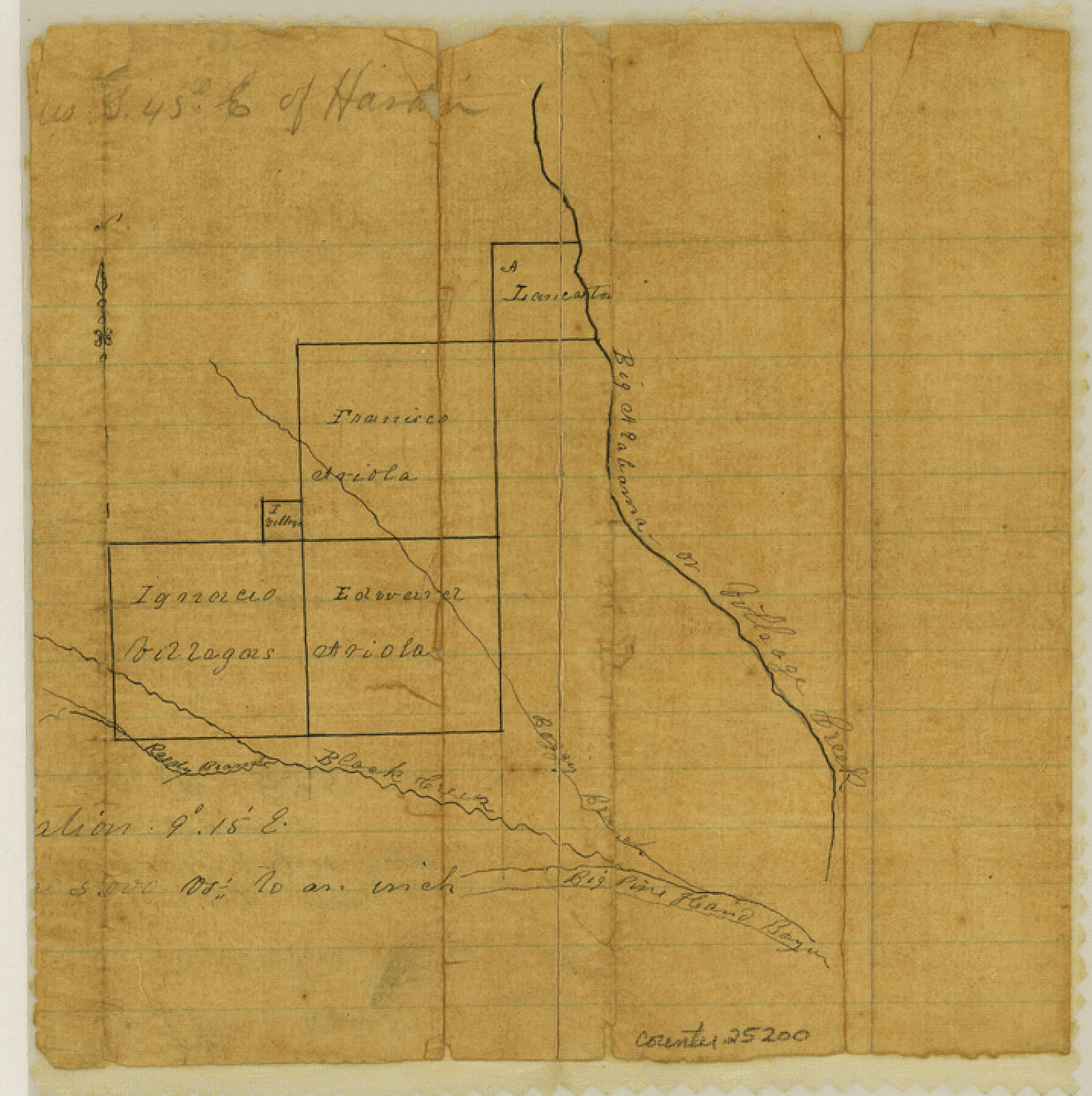
Hardin County Sketch File 47
[Office sketch of surveys lying southeast of Hardin]
-
Map/Doc
25200
-
Collection
General Map Collection
-
Object Dates
1875/11/16 (Creation Date)
-
Counties
Hardin
-
Subjects
Surveying Sketch File
-
Height x Width
7.2 x 7.2 inches
18.3 x 18.3 cm
-
Medium
paper, manuscript
-
Features
Big Alabama or Village Creek
Big Alabama Creek
Village Creek
Boggy Creek
Black Creek
Big Pine Island Bayou
Part of: General Map Collection
Presidio County Working Sketch 125

Print $20.00
- Digital $50.00
Presidio County Working Sketch 125
1985
Size 32.7 x 27.9 inches
Map/Doc 71803
South Sulphur River, Harpers Crossing Sheet

Print $20.00
- Digital $50.00
South Sulphur River, Harpers Crossing Sheet
1925
Size 42.2 x 29.2 inches
Map/Doc 65169
Reagan County Sketch File 34

Print $4.00
- Digital $50.00
Reagan County Sketch File 34
Size 11.5 x 8.9 inches
Map/Doc 35030
Stonewall County Working Sketch 28

Print $20.00
- Digital $50.00
Stonewall County Working Sketch 28
1976
Size 34.5 x 39.2 inches
Map/Doc 62335
Gulf Intracoastal Waterway, Tex. - Aransas Bay to Corpus Christi Bay - Modified Route of Main Channel/Dredging

Print $20.00
- Digital $50.00
Gulf Intracoastal Waterway, Tex. - Aransas Bay to Corpus Christi Bay - Modified Route of Main Channel/Dredging
1958
Size 31.2 x 42.5 inches
Map/Doc 61897
Map of the County of Cameron

Print $40.00
- Digital $50.00
Map of the County of Cameron
1884
Size 59.4 x 35.8 inches
Map/Doc 76058
San Augustine Co.

Print $40.00
- Digital $50.00
San Augustine Co.
1949
Size 48.9 x 32.2 inches
Map/Doc 95632
Wood County Rolled Sketch 5

Print $20.00
- Digital $50.00
Wood County Rolled Sketch 5
1950
Size 36.8 x 40.2 inches
Map/Doc 10161
Red River, Bois D'Arc Creek Floodway Sheet No. 7

Print $20.00
- Digital $50.00
Red River, Bois D'Arc Creek Floodway Sheet No. 7
1917
Size 29.0 x 23.8 inches
Map/Doc 69662
Fannin County Sketch File 8

Print $4.00
- Digital $50.00
Fannin County Sketch File 8
Size 8.7 x 13.3 inches
Map/Doc 22453
Winkler County Working Sketch 1

Print $20.00
- Digital $50.00
Winkler County Working Sketch 1
1944
Size 17.5 x 38.9 inches
Map/Doc 72595
Flight Mission No. DQO-7K, Frame 78, Galveston County

Print $20.00
- Digital $50.00
Flight Mission No. DQO-7K, Frame 78, Galveston County
1952
Size 18.8 x 22.4 inches
Map/Doc 85105
You may also like
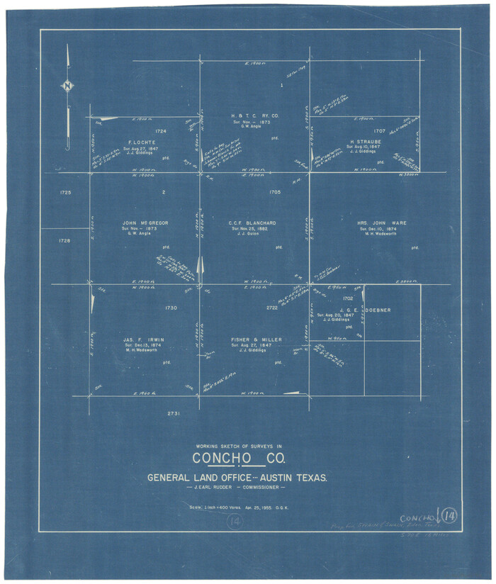
Concho County Working Sketch 14
Print $20.00
- Digital $50.00
Concho County Working Sketch 14
1955
Size 24.7 x 21.0 inches
Map/Doc 68196
[Blocks T1, T2, T3, and Vicinity]
![90983, [Blocks T1, T2, T3, and Vicinity], Twichell Survey Records](https://historictexasmaps.com/wmedia_w700/maps/90983-1.tif.jpg)
Print $20.00
- Digital $50.00
[Blocks T1, T2, T3, and Vicinity]
Size 30.3 x 33.6 inches
Map/Doc 90983
Newton County Aerial Photograph Index Sheet 5

Print $20.00
- Digital $50.00
Newton County Aerial Photograph Index Sheet 5
1953
Size 24.1 x 17.7 inches
Map/Doc 83734
Flight Mission No. CRK-3P, Frame 130, Refugio County

Print $20.00
- Digital $50.00
Flight Mission No. CRK-3P, Frame 130, Refugio County
1956
Size 18.6 x 22.3 inches
Map/Doc 86918
Flight Mission No. DQO-3K, Frame 31, Galveston County

Print $20.00
- Digital $50.00
Flight Mission No. DQO-3K, Frame 31, Galveston County
1952
Size 18.9 x 22.5 inches
Map/Doc 85072
Flight Mission No. BRA-16M, Frame 128, Jefferson County

Print $20.00
- Digital $50.00
Flight Mission No. BRA-16M, Frame 128, Jefferson County
1953
Size 18.6 x 22.7 inches
Map/Doc 85738
Gregg County Working Sketch 16

Print $20.00
- Digital $50.00
Gregg County Working Sketch 16
1944
Size 14.8 x 27.9 inches
Map/Doc 63283
Armstrong County

Print $20.00
- Digital $50.00
Armstrong County
1879
Size 21.6 x 19.2 inches
Map/Doc 3242
Stonewall County Sketch File 7

Print $24.00
- Digital $50.00
Stonewall County Sketch File 7
1896
Size 11.4 x 7.4 inches
Map/Doc 37213
Township No. 4 South Range No. 19 West of the Indian Meridian

Print $20.00
- Digital $50.00
Township No. 4 South Range No. 19 West of the Indian Meridian
1875
Size 19.1 x 24.5 inches
Map/Doc 75183
Kerr County Sketch File 12

Print $4.00
- Digital $50.00
Kerr County Sketch File 12
1901
Size 6.7 x 11.1 inches
Map/Doc 28881
Kimble County Working Sketch 73

Print $20.00
- Digital $50.00
Kimble County Working Sketch 73
1966
Size 21.3 x 18.5 inches
Map/Doc 70141