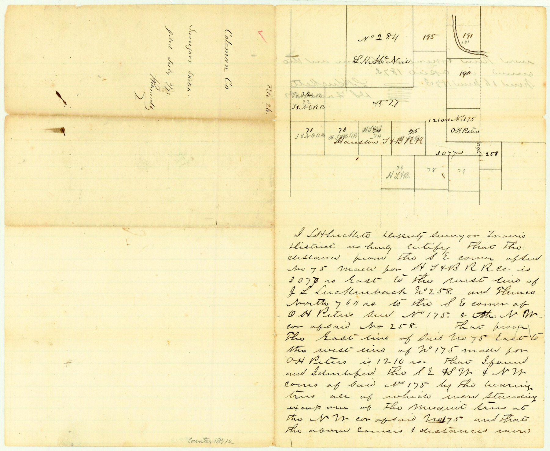
Coleman County Sketch File 26
[Sketch of T. & N. O. and H. T. & B. surveys around survey 77 northeast of Coleman]
-
Map/Doc
18712
-
Collection
General Map Collection
-
Object Dates
1873 (Survey Date)
1873/7/3 (File Date)
1873/6/16 (Creation Date)
-
People and Organizations
L.H. Luckett (Surveyor/Engineer)
-
Counties
Coleman
-
Subjects
Surveying Sketch File
-
Height x Width
12.7 x 15.5 inches
32.3 x 39.4 cm
-
Medium
paper, manuscript
Part of: General Map Collection
El Paso County Boundary File 10

Print $14.00
- Digital $50.00
El Paso County Boundary File 10
Size 12.7 x 8.2 inches
Map/Doc 53118
Galveston County Rolled Sketch 34A

Print $20.00
- Digital $50.00
Galveston County Rolled Sketch 34A
1978
Size 30.2 x 40.9 inches
Map/Doc 5967
Reeves County Rolled Sketch 30

Print $20.00
- Digital $50.00
Reeves County Rolled Sketch 30
1988
Size 18.4 x 24.4 inches
Map/Doc 7499
McLennan County Sketch File 7b

Print $6.00
- Digital $50.00
McLennan County Sketch File 7b
1857
Size 8.0 x 10.1 inches
Map/Doc 31248
Palo Pinto County Sketch File 27

Print $21.00
- Digital $50.00
Palo Pinto County Sketch File 27
1875
Size 9.8 x 15.7 inches
Map/Doc 33430
Brazoria County Sketch File 15

Print $4.00
- Digital $50.00
Brazoria County Sketch File 15
1892
Size 12.8 x 8.4 inches
Map/Doc 14977
El Paso County Sketch File 38

Print $4.00
- Digital $50.00
El Paso County Sketch File 38
1987
Size 14.3 x 8.9 inches
Map/Doc 22223
Reagan County

Print $40.00
- Digital $50.00
Reagan County
1940
Size 50.5 x 37.7 inches
Map/Doc 78430
Go Turnpike! Dallas-Fort Worth Turnpike (Recto)

Go Turnpike! Dallas-Fort Worth Turnpike (Recto)
1963
Size 11.2 x 17.2 inches
Map/Doc 94177
Hays County Rolled Sketch 20A

Print $20.00
- Digital $50.00
Hays County Rolled Sketch 20A
Size 20.7 x 23.9 inches
Map/Doc 6177
Bee County Working Sketch 1

Print $20.00
- Digital $50.00
Bee County Working Sketch 1
Size 23.2 x 40.4 inches
Map/Doc 67251
Limestone County Working Sketch 20

Print $20.00
- Digital $50.00
Limestone County Working Sketch 20
1976
Size 41.5 x 42.3 inches
Map/Doc 70570
You may also like
Henderson County Sketch File 4

Print $4.00
- Digital $50.00
Henderson County Sketch File 4
1851
Size 12.9 x 8.3 inches
Map/Doc 26323
Bexar County Sketch File 37

Print $5.00
- Digital $50.00
Bexar County Sketch File 37
1861
Size 16.2 x 8.2 inches
Map/Doc 14512
Corpus Christi and Rio Grande Railway Company

Print $20.00
Corpus Christi and Rio Grande Railway Company
Size 14.6 x 24.0 inches
Map/Doc 95314
Pecos County Working Sketch 139

Print $20.00
- Digital $50.00
Pecos County Working Sketch 139
1982
Size 31.1 x 24.9 inches
Map/Doc 71613
Brewster County Rolled Sketch 78

Print $20.00
- Digital $50.00
Brewster County Rolled Sketch 78
1945
Size 19.8 x 28.0 inches
Map/Doc 5243
Cottle County Sketch File 6c

Print $8.00
- Digital $50.00
Cottle County Sketch File 6c
Size 14.2 x 8.6 inches
Map/Doc 19480
Photo Index of Texas Coast - Sheet 2 of 6

Print $20.00
- Digital $50.00
Photo Index of Texas Coast - Sheet 2 of 6
1954
Size 20.0 x 24.0 inches
Map/Doc 83439
Fractional Township No. 8 South Range No. 13 East of the Indian Meridian, Indian Territory

Print $20.00
- Digital $50.00
Fractional Township No. 8 South Range No. 13 East of the Indian Meridian, Indian Territory
1896
Size 19.1 x 24.3 inches
Map/Doc 75224
Van Zandt County Sketch File 26

Print $4.00
- Digital $50.00
Van Zandt County Sketch File 26
1858
Size 6.7 x 7.9 inches
Map/Doc 39445
Morris County Rolled Sketch 2A

Print $20.00
- Digital $50.00
Morris County Rolled Sketch 2A
Size 24.3 x 19.2 inches
Map/Doc 10264
Railroad Track Map, H&TCRRCo., Falls County, Texas

Print $4.00
- Digital $50.00
Railroad Track Map, H&TCRRCo., Falls County, Texas
1918
Size 11.5 x 18.5 inches
Map/Doc 62856
[Sketch showing G. & M. Blocks 5 and M-19 and B. S. & F. Block 9]
![91718, [Sketch showing G. & M. Blocks 5 and M-19 and B. S. & F. Block 9], Twichell Survey Records](https://historictexasmaps.com/wmedia_w700/maps/91718-1.tif.jpg)
Print $20.00
- Digital $50.00
[Sketch showing G. & M. Blocks 5 and M-19 and B. S. & F. Block 9]
Size 22.9 x 17.4 inches
Map/Doc 91718