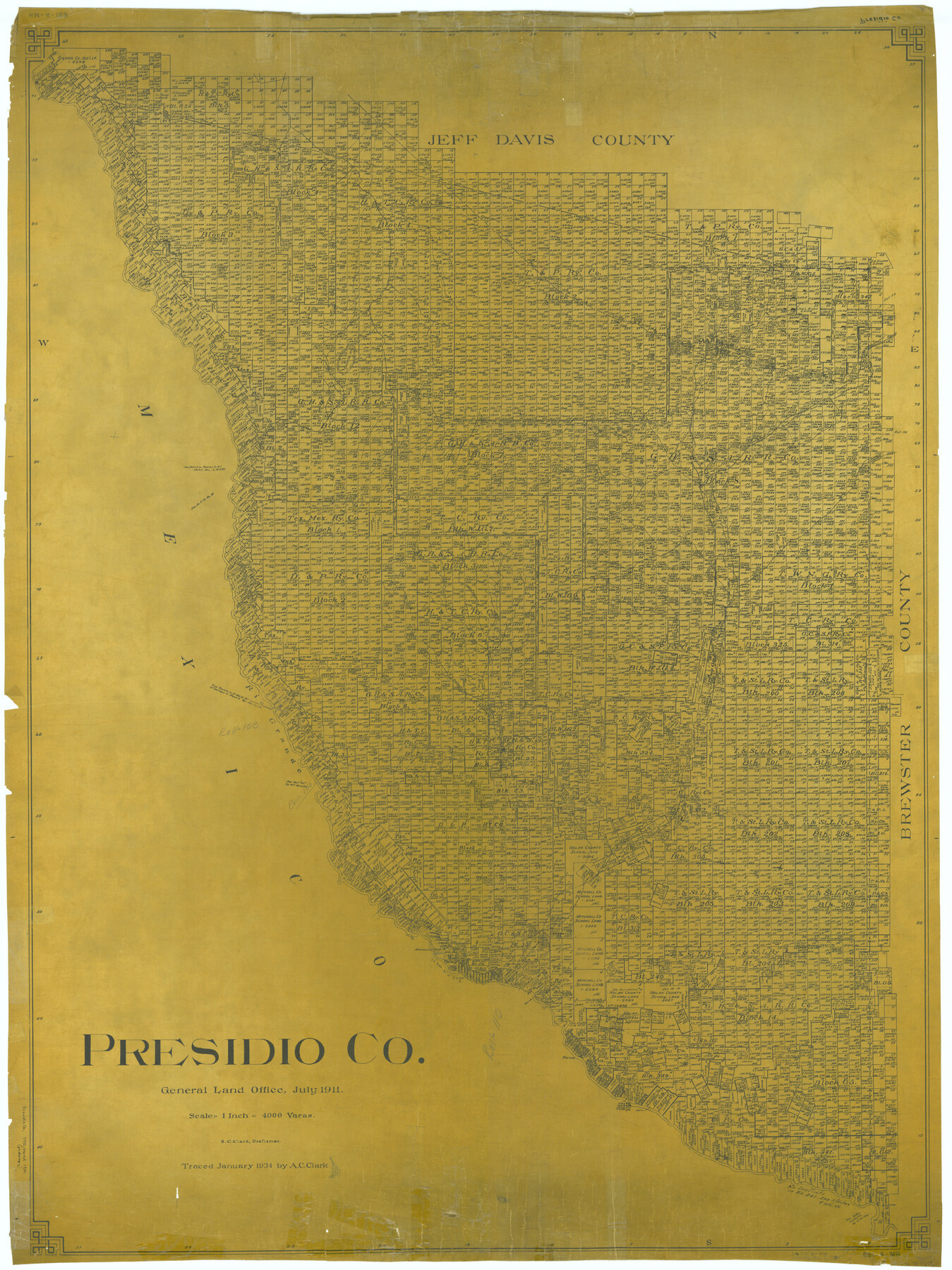
Presidio Co.
RM-4-189
-
Map/Doc
1894
-
Collection
General Map Collection
-
Object Dates
1911 (Creation Date)
-
People and Organizations
Texas General Land Office (Publisher)
S.C. Clark (Compiler)
S.C. Clark (Draftsman)
-
Counties
Presidio
-
Subjects
County
-
Height x Width
51.0 x 38.2 inches
129.5 x 97.0 cm
-
Comments
Traced in January 1934 by A. C. Clark.
Part of: General Map Collection
[Northeast portion of Grayson County]
![78364, [Northeast portion of Grayson County], General Map Collection](https://historictexasmaps.com/wmedia_w700/maps/78364.tif.jpg)
Print $20.00
- Digital $50.00
[Northeast portion of Grayson County]
Size 12.0 x 14.0 inches
Map/Doc 78364
Deaf Smith County Sketch File D

Print $20.00
- Digital $50.00
Deaf Smith County Sketch File D
Size 12.6 x 27.7 inches
Map/Doc 11306
Flight Mission No. BRA-8M, Frame 27, Jefferson County

Print $20.00
- Digital $50.00
Flight Mission No. BRA-8M, Frame 27, Jefferson County
1953
Size 18.6 x 22.3 inches
Map/Doc 85582
Grayson County Working Sketch 5

Print $20.00
- Digital $50.00
Grayson County Working Sketch 5
1939
Size 28.4 x 40.6 inches
Map/Doc 63244
Medina County

Print $40.00
- Digital $50.00
Medina County
1976
Size 50.6 x 40.9 inches
Map/Doc 77370
[Atlas B, Table of Contents]
![78269, [Atlas B, Table of Contents], General Map Collection](https://historictexasmaps.com/wmedia_w700/maps/78269.tif.jpg)
Print $3.00
- Digital $50.00
[Atlas B, Table of Contents]
Size 10.3 x 9.6 inches
Map/Doc 78269
Randall County

Print $20.00
- Digital $50.00
Randall County
1958
Size 43.0 x 35.1 inches
Map/Doc 73269
Terrell County Sketch File 7

Print $20.00
- Digital $50.00
Terrell County Sketch File 7
1890
Size 13.1 x 16.2 inches
Map/Doc 12418
Amistad International Reservoir on Rio Grande 105

Print $20.00
- Digital $50.00
Amistad International Reservoir on Rio Grande 105
1950
Size 28.5 x 40.8 inches
Map/Doc 75536


Texas - Official Highway Travel Map

Texas - Official Highway Travel Map
Size 27.4 x 36.4 inches
Map/Doc 94299
You may also like
San Augustine County Sketch File 13a

Print $4.00
San Augustine County Sketch File 13a
1879
Size 8.9 x 14.5 inches
Map/Doc 35660
Hamilton County Rolled Sketch 14

Print $20.00
- Digital $50.00
Hamilton County Rolled Sketch 14
1989
Size 28.0 x 40.0 inches
Map/Doc 6063
Texas Official Highway Travel Map

Texas Official Highway Travel Map
Size 27.3 x 36.4 inches
Map/Doc 94308
Pecos County Rolled Sketch JAS-1A

Print $40.00
- Digital $50.00
Pecos County Rolled Sketch JAS-1A
1960
Size 43.5 x 63.3 inches
Map/Doc 9746
[Plat map showing mostly Overton Addition]
![92812, [Plat map showing mostly Overton Addition], Twichell Survey Records](https://historictexasmaps.com/wmedia_w700/maps/92812-1.tif.jpg)
Print $20.00
- Digital $50.00
[Plat map showing mostly Overton Addition]
Size 31.9 x 31.3 inches
Map/Doc 92812
Colorado River, Buecher State Park

Print $4.00
- Digital $50.00
Colorado River, Buecher State Park
1934
Size 20.8 x 11.6 inches
Map/Doc 65324
Tyler County Rolled Sketch 2

Print $20.00
- Digital $50.00
Tyler County Rolled Sketch 2
1944
Size 29.6 x 17.4 inches
Map/Doc 8056
Outer Continental Shelf Leasing Maps (Texas Offshore Operations)

Print $20.00
- Digital $50.00
Outer Continental Shelf Leasing Maps (Texas Offshore Operations)
Size 14.7 x 17.4 inches
Map/Doc 75845
St. Marks to Galveston - Sheet II

Print $20.00
- Digital $50.00
St. Marks to Galveston - Sheet II
1846
Size 26.5 x 40.5 inches
Map/Doc 97397
San Patricio County Working Sketch 20
Print $20.00
- Digital $50.00
San Patricio County Working Sketch 20
1965
Size 37.2 x 32.3 inches
Map/Doc 63782
San Patricio County Working Sketch 14

Print $20.00
- Digital $50.00
San Patricio County Working Sketch 14
1949
Size 34.9 x 28.2 inches
Map/Doc 63776
General Highway Map, Maverick County, Texas

Print $20.00
General Highway Map, Maverick County, Texas
1961
Size 18.2 x 24.6 inches
Map/Doc 79587