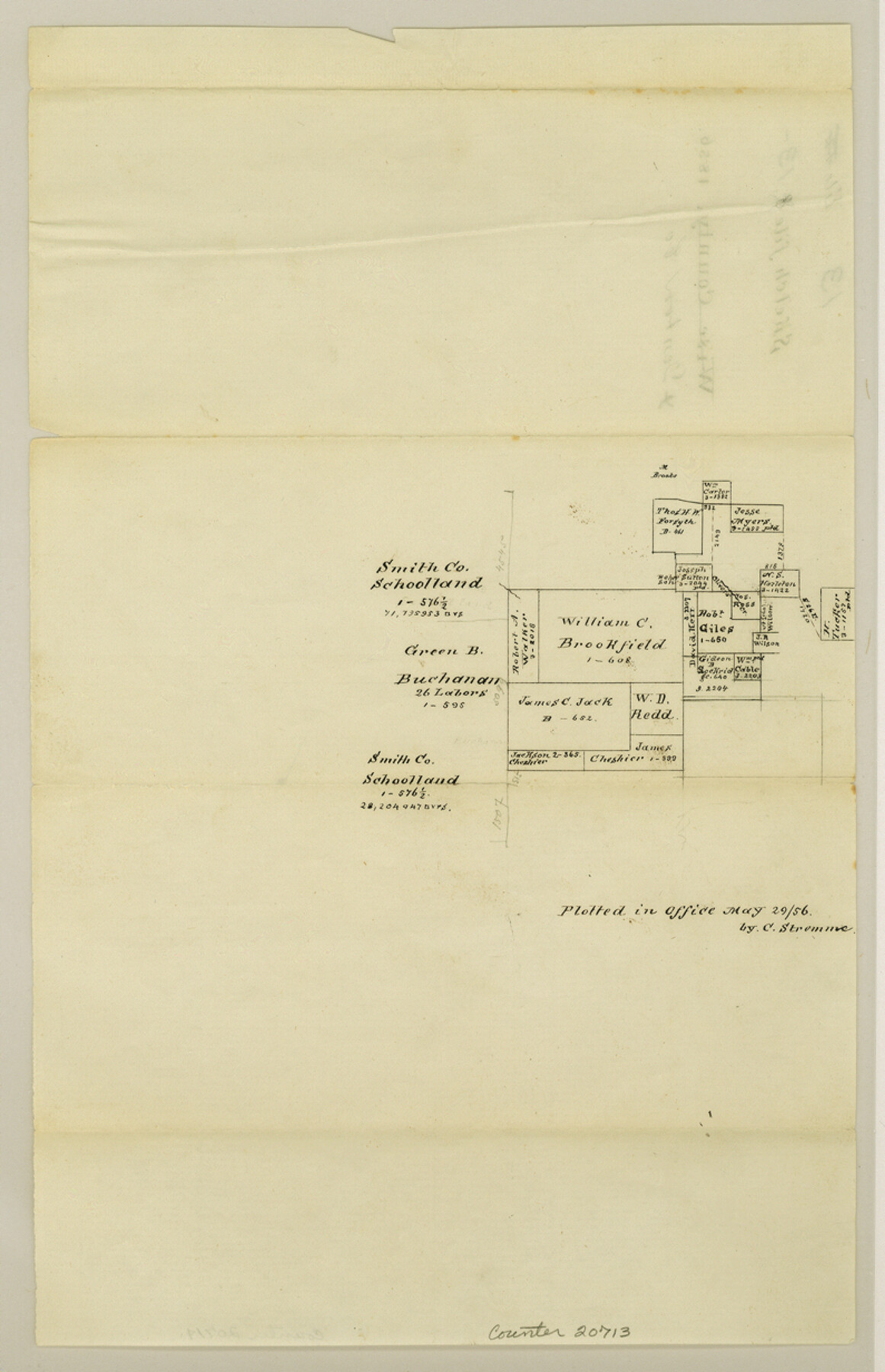
Denton County Sketch File 13
[Multiple sketches on Hickory Creek and Fraction Creek]
-
Map/Doc
20713
-
Collection
General Map Collection
-
Object Dates
1856/10/23 (Creation Date)
1856/11/1 (File Date)
1856/5/29 (Creation Date)
-
People and Organizations
Charles C. Lacy (Surveyor/Engineer)
C. Stremme (Draftsman)
-
Counties
Denton Tarrant
-
Subjects
Surveying Sketch File
-
Height x Width
12.3 x 7.9 inches
31.2 x 20.1 cm
-
Medium
paper, manuscript
-
Scale
1:4000
-
Features
Oliver's Creek
Hickory Creek
Fraction Creek
West Fork
Part of: General Map Collection
Parmer County Sketch File 2

Print $26.00
- Digital $50.00
Parmer County Sketch File 2
1903
Size 7.2 x 8.7 inches
Map/Doc 33626
San Saba County Working Sketch 8

Print $20.00
- Digital $50.00
San Saba County Working Sketch 8
1979
Size 13.3 x 17.2 inches
Map/Doc 63796
Roseborough Lake Sheet, Bowie County, Red River

Print $20.00
- Digital $50.00
Roseborough Lake Sheet, Bowie County, Red River
1934
Size 39.5 x 23.0 inches
Map/Doc 75273
[Surveys in the Bexar District along the Atascosa Creek]
![221, [Surveys in the Bexar District along the Atascosa Creek], General Map Collection](https://historictexasmaps.com/wmedia_w700/maps/221.tif.jpg)
Print $2.00
- Digital $50.00
[Surveys in the Bexar District along the Atascosa Creek]
1842
Size 5.9 x 5.9 inches
Map/Doc 221
Jeff Davis County Sketch File 41

Print $40.00
- Digital $50.00
Jeff Davis County Sketch File 41
1959
Size 13.3 x 13.4 inches
Map/Doc 28064
Outer Continental Shelf Leasing Maps (Louisiana Offshore Operations)

Print $20.00
- Digital $50.00
Outer Continental Shelf Leasing Maps (Louisiana Offshore Operations)
1955
Size 19.9 x 13.4 inches
Map/Doc 75860
Brewster County Sketch File N-27

Print $40.00
- Digital $50.00
Brewster County Sketch File N-27
Size 16.0 x 17.9 inches
Map/Doc 10972
Parker County Working Sketch 2

Print $20.00
- Digital $50.00
Parker County Working Sketch 2
1920
Map/Doc 71452
Milam County Boundary File 1

Print $8.00
- Digital $50.00
Milam County Boundary File 1
Size 12.7 x 8.2 inches
Map/Doc 57198
Travis County Appraisal District Plat Map 2_1004

Print $20.00
- Digital $50.00
Travis County Appraisal District Plat Map 2_1004
Size 21.4 x 26.5 inches
Map/Doc 94238
[FT. W. & R. G. Ry. Right of Way Map, Winchell to Brady, McCulloch County, Texas]
![61414, [FT. W. & R. G. Ry. Right of Way Map, Winchell to Brady, McCulloch County, Texas], General Map Collection](https://historictexasmaps.com/wmedia_w700/maps/61414.tif.jpg)
Print $40.00
- Digital $50.00
[FT. W. & R. G. Ry. Right of Way Map, Winchell to Brady, McCulloch County, Texas]
1918
Size 38.2 x 122.0 inches
Map/Doc 61414

You may also like
Amistad International Reservoir on Rio Grande 106

Print $20.00
- Digital $50.00
Amistad International Reservoir on Rio Grande 106
1950
Size 28.5 x 41.0 inches
Map/Doc 75537
Glasscock County Working Sketch 17

Print $20.00
- Digital $50.00
Glasscock County Working Sketch 17
1990
Size 27.7 x 30.6 inches
Map/Doc 63190
Gregg County Rolled Sketch RGA

Print $46.00
- Digital $50.00
Gregg County Rolled Sketch RGA
1933
Size 34.3 x 30.6 inches
Map/Doc 9026
Intracoastal Waterway - Galveston Bay to West Bay including Galveston Bay Entrance

Print $20.00
- Digital $50.00
Intracoastal Waterway - Galveston Bay to West Bay including Galveston Bay Entrance
1962
Size 26.9 x 38.6 inches
Map/Doc 69936
Part of Laguna Madre in Willacy and Cameron Counties, showing Subdivision for Mineral Development

Print $20.00
- Digital $50.00
Part of Laguna Madre in Willacy and Cameron Counties, showing Subdivision for Mineral Development
1950
Size 45.1 x 36.8 inches
Map/Doc 1925
Aransas County Sketch File 19

Print $4.00
- Digital $50.00
Aransas County Sketch File 19
Size 11.7 x 8.9 inches
Map/Doc 13153
Young County Sketch File 9a

Print $4.00
- Digital $50.00
Young County Sketch File 9a
1875
Size 12.9 x 8.3 inches
Map/Doc 40866
Walker County Rolled Sketch 1

Print $20.00
- Digital $50.00
Walker County Rolled Sketch 1
1982
Size 36.3 x 23.6 inches
Map/Doc 8154

[Aaron Cherry and A. M. de Lejarza Surveys on the Trinity River]
![91080, [Aaron Cherry and A. M. de Lejarza Surveys on the Trinity River], Twichell Survey Records](https://historictexasmaps.com/wmedia_w700/maps/91080-1.tif.jpg)
Print $20.00
- Digital $50.00
[Aaron Cherry and A. M. de Lejarza Surveys on the Trinity River]
Size 26.3 x 14.1 inches
Map/Doc 91080
[Blocks L. E. and B8]
![90666, [Blocks L. E. and B8], Twichell Survey Records](https://historictexasmaps.com/wmedia_w700/maps/90666-2.tif.jpg)
Print $20.00
- Digital $50.00
[Blocks L. E. and B8]
Size 18.4 x 13.6 inches
Map/Doc 90666
Exhibit A to the Surveyors Report, R.W. Lillard vs J.M. Taylor, et al

Print $20.00
- Digital $50.00
Exhibit A to the Surveyors Report, R.W. Lillard vs J.M. Taylor, et al
1881
Size 12.4 x 12.9 inches
Map/Doc 683