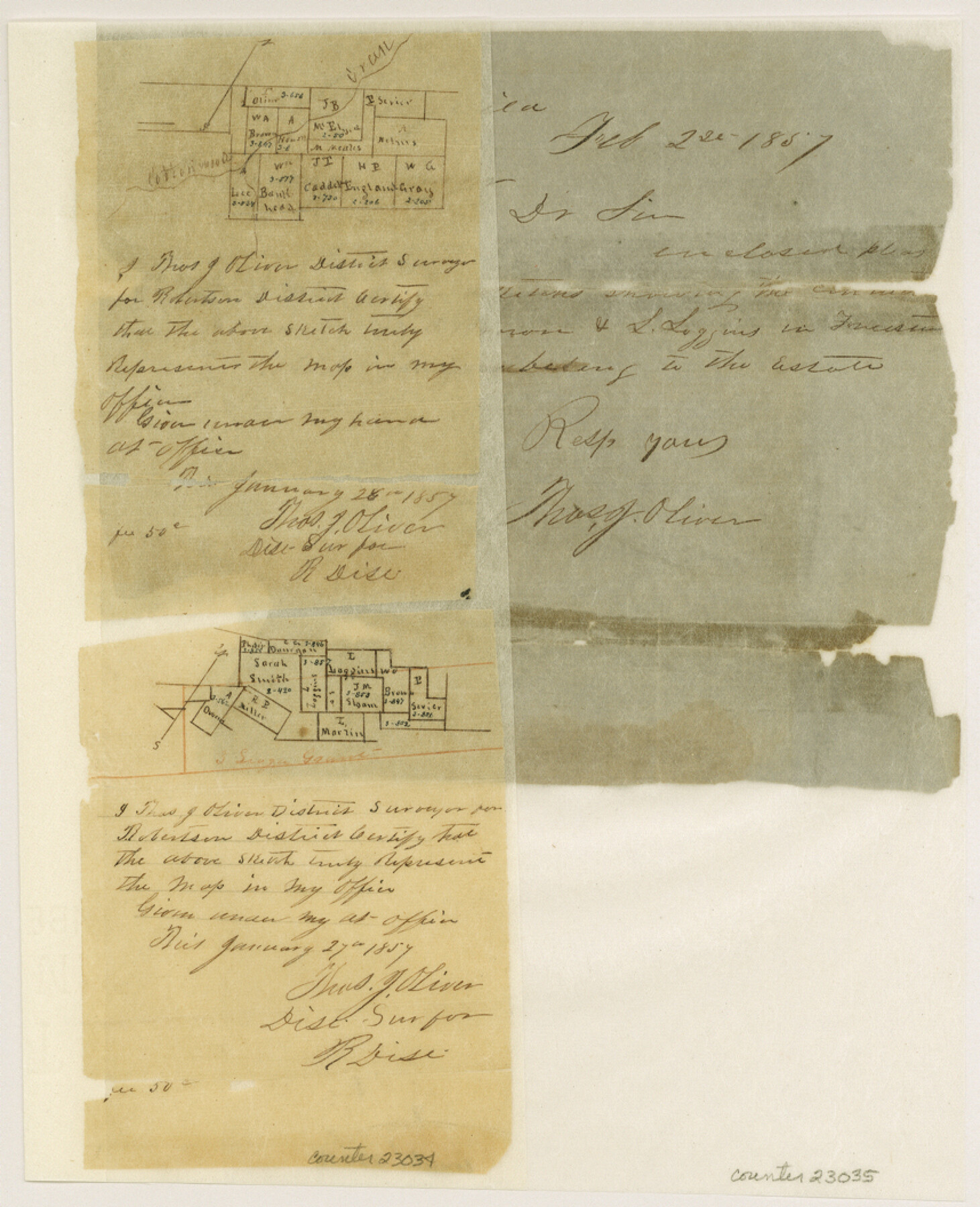
Freestone County Sketch File 1
[Sketch of surveys on Oak and Cedar Creeks]
-
Map/Doc
23034
-
Collection
General Map Collection
-
Object Dates
1857/2/2 (Creation Date)
1857/3/19 (File Date)
1857/1/28 (Creation Date)
-
People and Organizations
Thomas J. Oliver (Surveyor/Engineer)
-
Counties
Freestone
-
Subjects
Surveying Sketch File
-
Height x Width
10.6 x 8.6 inches
26.9 x 21.8 cm
-
Medium
paper, manuscript
-
Features
Cottonwood Creek
[Oak Creek]
[Cedar Creek]
Part of: General Map Collection
Fannin County Boundary File 1a

Print $40.00
- Digital $50.00
Fannin County Boundary File 1a
1882
Size 36.5 x 9.5 inches
Map/Doc 53279
San Jacinto County Sketch File 6

Print $4.00
San Jacinto County Sketch File 6
1847
Size 12.7 x 8.2 inches
Map/Doc 35703
Nueces River, Clarkwood Sheet

Print $6.00
- Digital $50.00
Nueces River, Clarkwood Sheet
1942
Size 26.9 x 36.5 inches
Map/Doc 65099
Right of Way and Track Map, Houston & Texas Central R.R. operated by the T. and N. O. R.R., Fort Worth Branch

Print $40.00
- Digital $50.00
Right of Way and Track Map, Houston & Texas Central R.R. operated by the T. and N. O. R.R., Fort Worth Branch
1918
Size 31.7 x 56.8 inches
Map/Doc 64784

Val Verde County Sketch File 40A

Print $4.00
- Digital $50.00
Val Verde County Sketch File 40A
1939
Size 11.3 x 8.9 inches
Map/Doc 39307
Lynn County Working Sketch 1

Print $20.00
- Digital $50.00
Lynn County Working Sketch 1
1945
Size 17.2 x 14.0 inches
Map/Doc 70671
[Location, Fort Worth & Denver Railroad, through Wilbarger County]
![64344, [Location, Fort Worth & Denver Railroad, through Wilbarger County], General Map Collection](https://historictexasmaps.com/wmedia_w700/maps/64344.tif.jpg)
Print $40.00
- Digital $50.00
[Location, Fort Worth & Denver Railroad, through Wilbarger County]
Size 20.8 x 123.5 inches
Map/Doc 64344

Atascosa County Working Sketch 1b

Print $20.00
- Digital $50.00
Atascosa County Working Sketch 1b
1908
Size 36.2 x 39.0 inches
Map/Doc 67195
San Augustine County Sketch File 18

Print $6.00
San Augustine County Sketch File 18
Size 14.4 x 8.9 inches
Map/Doc 35675
Brazoria County Working Sketch 24

Print $20.00
- Digital $50.00
Brazoria County Working Sketch 24
1963
Size 35.7 x 25.0 inches
Map/Doc 67509
You may also like
Deaf Smith County Sketch File Z

Print $34.00
- Digital $50.00
Deaf Smith County Sketch File Z
1903
Size 9.6 x 4.7 inches
Map/Doc 20651
Texas Intracoastal Waterway - Laguna Madre - Dagger Hill to Potrero Grande

Print $20.00
- Digital $50.00
Texas Intracoastal Waterway - Laguna Madre - Dagger Hill to Potrero Grande
Size 39.0 x 27.3 inches
Map/Doc 73508
Sketch of Surveys in Knox, Baylor, Haskell and Throckmorton Ctes

Print $40.00
- Digital $50.00
Sketch of Surveys in Knox, Baylor, Haskell and Throckmorton Ctes
1888
Size 43.3 x 58.5 inches
Map/Doc 4386
Hunt County Sketch File 32

Print $6.00
- Digital $50.00
Hunt County Sketch File 32
Size 7.9 x 11.6 inches
Map/Doc 27138
The Great Lakes Region of the United States and Canada

The Great Lakes Region of the United States and Canada
1953
Size 42.5 x 28.6 inches
Map/Doc 92396
Angelina County Working Sketch 7

Print $20.00
- Digital $50.00
Angelina County Working Sketch 7
1920
Size 25.5 x 23.7 inches
Map/Doc 67088
Hamilton Dam, Reservoir Clearing

Print $4.00
- Digital $50.00
Hamilton Dam, Reservoir Clearing
1936
Size 10.5 x 28.9 inches
Map/Doc 2096
General Highway Map. Detail of Cities and Towns in Walker County, Texas [Huntsville and vicinity]
![79699, General Highway Map. Detail of Cities and Towns in Walker County, Texas [Huntsville and vicinity], Texas State Library and Archives](https://historictexasmaps.com/wmedia_w700/maps/79699.tif.jpg)
Print $20.00
General Highway Map. Detail of Cities and Towns in Walker County, Texas [Huntsville and vicinity]
1961
Size 18.1 x 24.8 inches
Map/Doc 79699
Nueces County Rolled Sketch 106

Print $104.00
Nueces County Rolled Sketch 106
1986
Size 18.2 x 24.6 inches
Map/Doc 7097
Map of the Mexican National R.R. "Laredo Route" and Connections. The Scenic Short Line to the City of Mexico

Print $20.00
- Digital $50.00
Map of the Mexican National R.R. "Laredo Route" and Connections. The Scenic Short Line to the City of Mexico
1901
Size 24.2 x 24.3 inches
Map/Doc 95145
Williamson County Sketch File 30

Print $20.00
- Digital $50.00
Williamson County Sketch File 30
Size 24.6 x 18.7 inches
Map/Doc 12696
Map showing location of Texas Prison Farms surveyed for the Texas Prison System

Print $20.00
- Digital $50.00
Map showing location of Texas Prison Farms surveyed for the Texas Prison System
1934
Size 15.6 x 12.3 inches
Map/Doc 94277