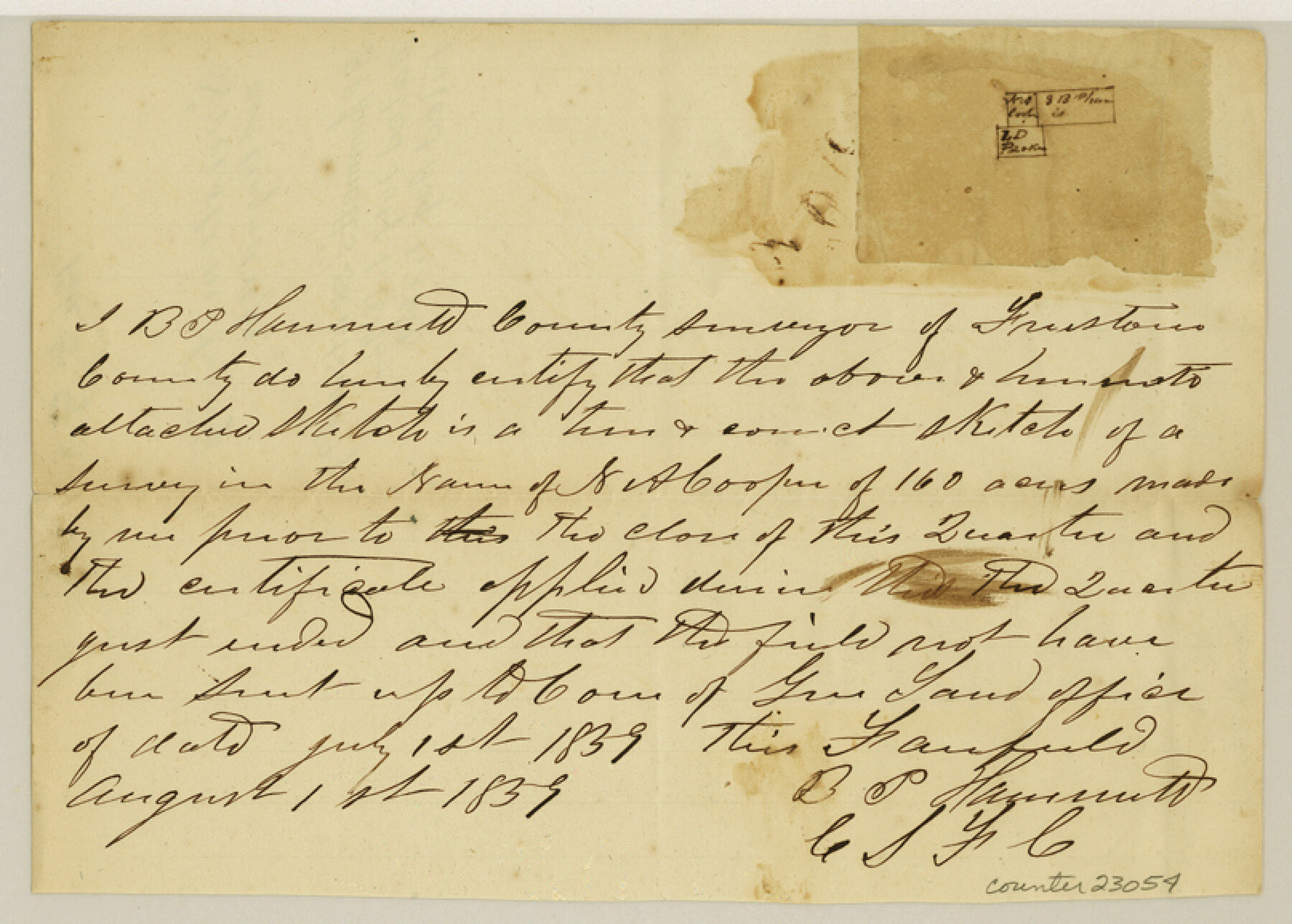
Freestone County Sketch File 8
[Small sketch of area in south part of county]
-
Map/Doc
23054
-
Collection
General Map Collection
-
Object Dates
1859/7/1 (Creation Date)
1859/8/1 (File Date)
1859 (Survey Date)
-
People and Organizations
B.P. Hammett (Surveyor/Engineer)
-
Counties
Freestone
-
Subjects
Surveying Sketch File
-
Height x Width
5.8 x 8.1 inches
14.7 x 20.6 cm
-
Medium
paper, manuscript
Part of: General Map Collection
Montague County Working Sketch 24

Print $20.00
- Digital $50.00
Montague County Working Sketch 24
1953
Size 21.9 x 27.6 inches
Map/Doc 71090
Dimmit County Working Sketch 48

Print $40.00
- Digital $50.00
Dimmit County Working Sketch 48
1980
Size 78.7 x 43.7 inches
Map/Doc 68709
Supreme Court of the United States, October Term, 1923, No. 15, Original - The State of Oklahoma, Complainant vs. The State of Texas, Defendant, The United States, Intervener; Report of the Boundary Commissioners

Print $98.00
- Digital $50.00
Supreme Court of the United States, October Term, 1923, No. 15, Original - The State of Oklahoma, Complainant vs. The State of Texas, Defendant, The United States, Intervener; Report of the Boundary Commissioners
1924
Size 6.1 x 9.2 inches
Map/Doc 3058
Dawson County Working Sketch 20

Print $20.00
- Digital $50.00
Dawson County Working Sketch 20
1963
Size 18.2 x 23.0 inches
Map/Doc 68564
Hudspeth County Sketch File 20

Print $40.00
- Digital $50.00
Hudspeth County Sketch File 20
Size 37.1 x 57.3 inches
Map/Doc 10494
Real County Sketch File 12

Print $20.00
- Digital $50.00
Real County Sketch File 12
1932
Size 13.9 x 19.2 inches
Map/Doc 12231
Travis County Appraisal District Plat Map 2_0805

Print $20.00
- Digital $50.00
Travis County Appraisal District Plat Map 2_0805
Size 21.4 x 26.4 inches
Map/Doc 94231
Old Miscellaneous File 38

Print $40.00
- Digital $50.00
Old Miscellaneous File 38
1841
Size 57.8 x 33.9 inches
Map/Doc 75282
Carson County Working Sketch 4

Print $20.00
- Digital $50.00
Carson County Working Sketch 4
1952
Size 26.1 x 37.0 inches
Map/Doc 67875
Goliad County Sketch File 9

Print $6.00
- Digital $50.00
Goliad County Sketch File 9
1849
Size 8.1 x 10.1 inches
Map/Doc 24223
[Right of Way & Track Map, The Texas & Pacific Ry. Co. Main Line]
![64659, [Right of Way & Track Map, The Texas & Pacific Ry. Co. Main Line], General Map Collection](https://historictexasmaps.com/wmedia_w700/maps/64659.tif.jpg)
Print $20.00
- Digital $50.00
[Right of Way & Track Map, The Texas & Pacific Ry. Co. Main Line]
Size 11.0 x 18.4 inches
Map/Doc 64659
El Paso County Rolled Sketch JE

Print $20.00
- Digital $50.00
El Paso County Rolled Sketch JE
1911
Size 27.4 x 45.5 inches
Map/Doc 8860
You may also like
Hardeman County Working Sketch 15

Print $40.00
- Digital $50.00
Hardeman County Working Sketch 15
1981
Size 42.9 x 49.1 inches
Map/Doc 63396
Flight Mission No. DQO-2K, Frame 96, Galveston County

Print $20.00
- Digital $50.00
Flight Mission No. DQO-2K, Frame 96, Galveston County
1952
Size 18.8 x 22.4 inches
Map/Doc 85023
Flight Mission No. DAG-23K, Frame 187, Matagorda County

Print $20.00
- Digital $50.00
Flight Mission No. DAG-23K, Frame 187, Matagorda County
1953
Size 17.5 x 22.4 inches
Map/Doc 86522
Collin County Texas

Print $20.00
- Digital $50.00
Collin County Texas
1895
Size 20.7 x 17.5 inches
Map/Doc 794
Atascosa County Working Sketch 14

Print $20.00
- Digital $50.00
Atascosa County Working Sketch 14
1932
Size 18.4 x 17.4 inches
Map/Doc 67210
![91965, [PSL Block B19], Twichell Survey Records](https://historictexasmaps.com/wmedia_w700/maps/91965-1.tif.jpg)
Liberty County Rolled Sketch J

Print $20.00
- Digital $50.00
Liberty County Rolled Sketch J
1943
Size 29.1 x 38.0 inches
Map/Doc 10646
Brewster County Rolled Sketch 43

Print $40.00
- Digital $50.00
Brewster County Rolled Sketch 43
1913
Size 38.6 x 63.8 inches
Map/Doc 8476
[Area along West County Line]
![90832, [Area along West County Line], Twichell Survey Records](https://historictexasmaps.com/wmedia_w700/maps/90832-2.tif.jpg)
Print $2.00
- Digital $50.00
[Area along West County Line]
Size 6.0 x 9.6 inches
Map/Doc 90832
Edwards County Boundary File 27

Print $8.00
- Digital $50.00
Edwards County Boundary File 27
Size 8.8 x 3.9 inches
Map/Doc 52876
Upton County Rolled Sketch 33

Print $20.00
- Digital $50.00
Upton County Rolled Sketch 33
1951
Size 39.2 x 33.0 inches
Map/Doc 8076
Atascosa County Rolled Sketch 14

Print $20.00
- Digital $50.00
Atascosa County Rolled Sketch 14
1944
Size 37.1 x 46.0 inches
Map/Doc 8430