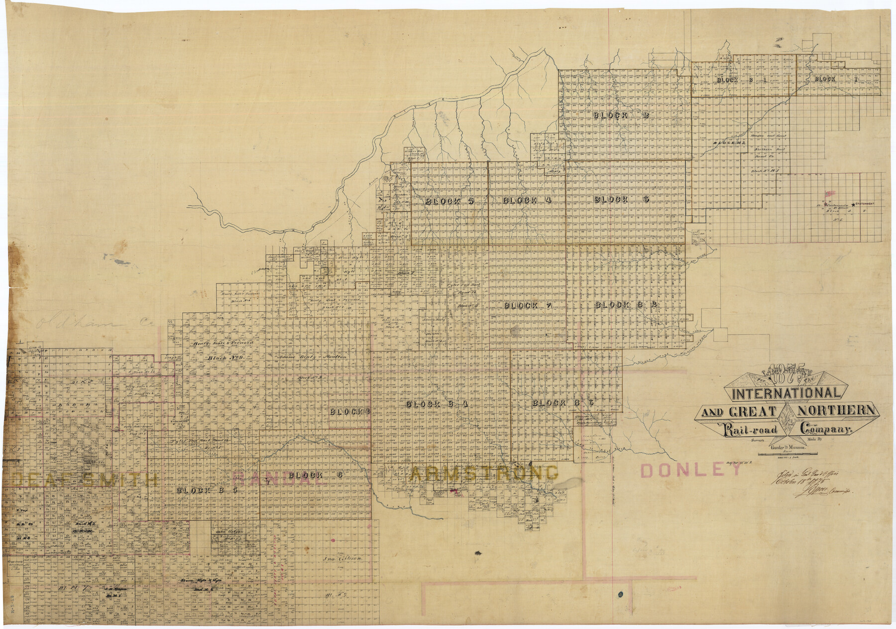
1875 land survey for the International and Great Northern Rail-road Company
N-2-78
-
Map/Doc
2306
-
Collection
General Map Collection
-
Object Dates
1875 (Creation Date)
-
People and Organizations
Gunter and Munson (Author)
-
Counties
Deaf Smith Randall Armstrong Donley
-
Subjects
County
-
Height x Width
42.5 x 60.6 inches
108.0 x 153.9 cm
Part of: General Map Collection
Val Verde County Sketch File A2

Print $10.00
- Digital $50.00
Val Verde County Sketch File A2
1916
Size 14.5 x 9.1 inches
Map/Doc 39041
Rusk County Sketch File 34

Print $20.00
Rusk County Sketch File 34
1949
Size 33.4 x 28.2 inches
Map/Doc 10597
St. Louis, Brownsville & Mexico Railway Location Map from Mile 100 to Mile 120

Print $40.00
- Digital $50.00
St. Louis, Brownsville & Mexico Railway Location Map from Mile 100 to Mile 120
1905
Size 19.4 x 67.8 inches
Map/Doc 64168
Hartley County Rolled Sketch 4

Print $20.00
- Digital $50.00
Hartley County Rolled Sketch 4
1902
Size 25.4 x 36.7 inches
Map/Doc 6159
Parker County Working Sketch 2

Print $20.00
- Digital $50.00
Parker County Working Sketch 2
1920
Map/Doc 71452
Central America Past and Present

Central America Past and Present
1986
Size 20.6 x 31.6 inches
Map/Doc 96839
Moore County Sketch File 10

Print $20.00
- Digital $50.00
Moore County Sketch File 10
1910
Size 18.7 x 30.1 inches
Map/Doc 42128
Mason County Rolled Sketch 4

Print $20.00
- Digital $50.00
Mason County Rolled Sketch 4
1983
Size 23.3 x 26.9 inches
Map/Doc 6677
Flight Mission No. CRE-1R, Frame 197, Jackson County

Print $20.00
- Digital $50.00
Flight Mission No. CRE-1R, Frame 197, Jackson County
1956
Size 18.5 x 22.4 inches
Map/Doc 85351
Ochiltree County Working Sketch 7

Print $40.00
- Digital $50.00
Ochiltree County Working Sketch 7
1968
Size 26.8 x 56.6 inches
Map/Doc 71320
Dallam County Boundary File 4

Print $80.00
- Digital $50.00
Dallam County Boundary File 4
Size 9.4 x 49.8 inches
Map/Doc 52082
Hardin County Working Sketch 44

Print $40.00
- Digital $50.00
Hardin County Working Sketch 44
1954
Size 53.1 x 39.5 inches
Map/Doc 69764
You may also like
Nueces County Rolled Sketch M-12

Print $20.00
- Digital $50.00
Nueces County Rolled Sketch M-12
1913
Size 24.9 x 40.0 inches
Map/Doc 7171
Sketch No. 2 Showing Land Ties with Houston & Texas Central Rail Road through Harris County, Texas

Print $20.00
- Digital $50.00
Sketch No. 2 Showing Land Ties with Houston & Texas Central Rail Road through Harris County, Texas
1880
Size 8.5 x 26.9 inches
Map/Doc 64496
Flight Mission No. BRA-16M, Frame 89, Jefferson County

Print $20.00
- Digital $50.00
Flight Mission No. BRA-16M, Frame 89, Jefferson County
1953
Size 18.6 x 22.4 inches
Map/Doc 85701
Coke County Sketch File 30

Print $40.00
- Digital $50.00
Coke County Sketch File 30
Size 12.2 x 17.6 inches
Map/Doc 18641
Runnels County Working Sketch 12

Print $20.00
- Digital $50.00
Runnels County Working Sketch 12
1950
Size 27.7 x 33.0 inches
Map/Doc 63608
[Sketch for Mineral Application 13436 - Cut-off Bayou]
![65675, [Sketch for Mineral Application 13436 - Cut-off Bayou], General Map Collection](https://historictexasmaps.com/wmedia_w700/maps/65675-1.tif.jpg)
Print $20.00
- Digital $50.00
[Sketch for Mineral Application 13436 - Cut-off Bayou]
1928
Size 21.3 x 44.3 inches
Map/Doc 65675
Republic Counties. January 1, 1838

Print $20.00
Republic Counties. January 1, 1838
2020
Size 24.5 x 21.7 inches
Map/Doc 96311
Sutton County Working Sketch 36

Print $20.00
- Digital $50.00
Sutton County Working Sketch 36
1945
Size 31.3 x 25.4 inches
Map/Doc 62379
Nueces County Sketch File 70

Print $8.00
- Digital $50.00
Nueces County Sketch File 70
Size 11.2 x 8.6 inches
Map/Doc 33007
Moore County Rolled Sketch 9

Print $20.00
- Digital $50.00
Moore County Rolled Sketch 9
1911
Size 24.9 x 18.2 inches
Map/Doc 6827
Subdivision for R.N. Graham

Print $3.00
- Digital $50.00
Subdivision for R.N. Graham
1913
Size 15.2 x 10.4 inches
Map/Doc 83430
Tyler County Sketch File 6-2

Print $20.00
- Digital $50.00
Tyler County Sketch File 6-2
1861
Size 16.8 x 22.5 inches
Map/Doc 12498