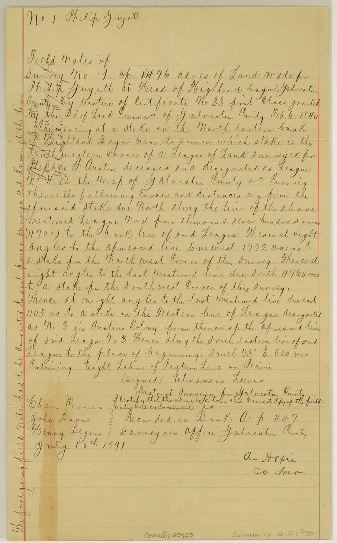
Galveston County Sketch File 37
[Miscellaneous field notes from 1A to 12A]
-
Map/Doc
23423
-
Collection
General Map Collection
-
Object Dates
1841/7/1 (Creation Date)
1891/7/18 (File Date)
1891 (Survey Date)
-
People and Organizations
A.B. Langermann (Surveyor/Engineer)
Elmanson Lewis (Surveyor/Engineer)
A. Hoxie (Surveyor/Engineer)
Henry Beguin (Chainman)
Philip Yoyatt (Chainman)
N.B. Yard (Chainman)
-
Counties
Galveston
-
Subjects
Surveying Sketch File
-
Height x Width
14.3 x 8.8 inches
36.3 x 22.4 cm
-
Medium
paper, manuscript
-
Features
Highland Bayou
Part of: General Map Collection
Township No. 5 South Range No. 14 West of the Indian Meridian

Print $4.00
- Digital $50.00
Township No. 5 South Range No. 14 West of the Indian Meridian
1875
Size 17.8 x 22.8 inches
Map/Doc 75147
Kimble County Working Sketch 93

Print $20.00
- Digital $50.00
Kimble County Working Sketch 93
1983
Size 31.5 x 37.8 inches
Map/Doc 70161

Van Zandt County Boundary File 2a

Print $20.00
- Digital $50.00
Van Zandt County Boundary File 2a
Size 20.3 x 20.1 inches
Map/Doc 59649
Brewster County Working Sketch 89

Print $20.00
- Digital $50.00
Brewster County Working Sketch 89
1974
Size 20.5 x 44.1 inches
Map/Doc 67689
Collin County Sketch File 14

Print $12.00
- Digital $50.00
Collin County Sketch File 14
1953
Size 11.2 x 8.7 inches
Map/Doc 18874
Glasscock County Rolled Sketch 18

Print $20.00
- Digital $50.00
Glasscock County Rolled Sketch 18
Size 24.2 x 24.0 inches
Map/Doc 96576
Flight Mission No. DQO-2K, Frame 134, Galveston County

Print $20.00
- Digital $50.00
Flight Mission No. DQO-2K, Frame 134, Galveston County
1952
Size 18.7 x 22.4 inches
Map/Doc 85031
Current Miscellaneous File 67

Print $8.00
- Digital $50.00
Current Miscellaneous File 67
1957
Size 11.2 x 8.8 inches
Map/Doc 74130
Knox County Sketch File 13

Print $10.00
- Digital $50.00
Knox County Sketch File 13
1892
Size 10.0 x 8.0 inches
Map/Doc 29230
Jasper County Working Sketch 24

Print $40.00
- Digital $50.00
Jasper County Working Sketch 24
1948
Size 44.2 x 54.9 inches
Map/Doc 69651
Harris County Sketch File 29

Print $15.00
- Digital $50.00
Harris County Sketch File 29
Size 14.1 x 9.0 inches
Map/Doc 25409
You may also like
Crockett County Rolled Sketch 1

Print $40.00
- Digital $50.00
Crockett County Rolled Sketch 1
1888
Size 36.5 x 61.1 inches
Map/Doc 76144
[Texas Gulf Coast]
![72677, [Texas Gulf Coast], General Map Collection](https://historictexasmaps.com/wmedia_w700/maps/72677.tif.jpg)
Print $20.00
- Digital $50.00
[Texas Gulf Coast]
Size 27.3 x 18.2 inches
Map/Doc 72677
Big Lake Oil Field

Print $20.00
- Digital $50.00
Big Lake Oil Field
1924
Size 27.3 x 19.1 inches
Map/Doc 2420
Walker County

Print $20.00
- Digital $50.00
Walker County
1944
Size 40.4 x 34.4 inches
Map/Doc 77448

Matagorda County Rolled Sketch 37A

Print $40.00
- Digital $50.00
Matagorda County Rolled Sketch 37A
Size 48.7 x 41.1 inches
Map/Doc 10195
Jeff Davis County Working Sketch 32

Print $40.00
- Digital $50.00
Jeff Davis County Working Sketch 32
1975
Size 66.7 x 43.7 inches
Map/Doc 66527
Harrison County Sketch File 19

Print $20.00
- Digital $50.00
Harrison County Sketch File 19
1954
Size 25.0 x 21.7 inches
Map/Doc 11692
Orange County Working Sketch 54b

Print $40.00
- Digital $50.00
Orange County Working Sketch 54b
2008
Size 38.0 x 50.3 inches
Map/Doc 88743
Reeves County

Print $40.00
- Digital $50.00
Reeves County
1945
Size 48.6 x 39.6 inches
Map/Doc 63001
Flight Mission No. DCL-6C, Frame 158, Kenedy County

Print $20.00
- Digital $50.00
Flight Mission No. DCL-6C, Frame 158, Kenedy County
1943
Size 15.3 x 15.2 inches
Map/Doc 85984
