Hall County Sketch File 9a
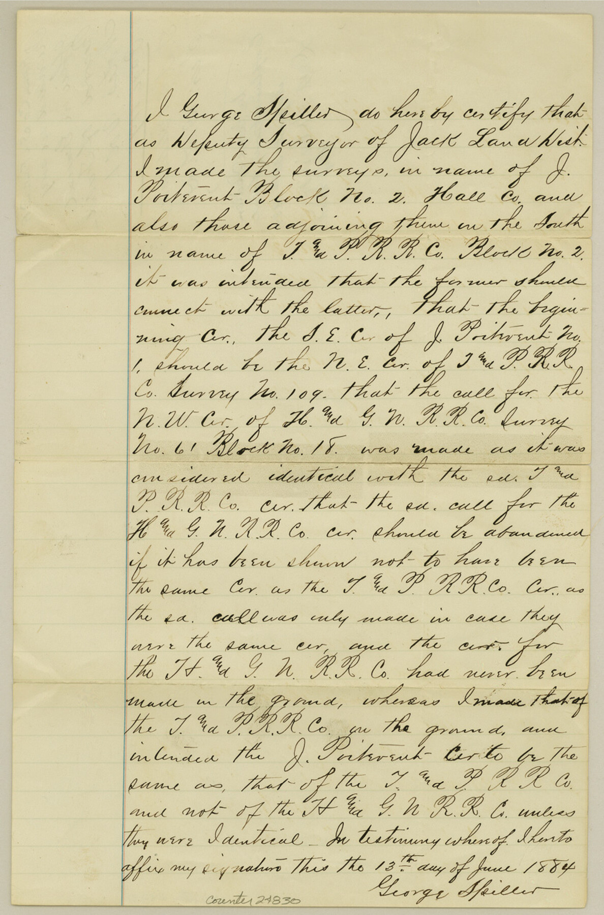
[Explanation regarding Block 2, J. Poitevent and T. & P. RR. Co. surveys]
-
Map/Doc
24830
-
Collection
General Map Collection
-
Object Dates
1884/6/13 (Creation Date)
1884/8/30 (File Date)
-
People and Organizations
George Spiller (Surveyor/Engineer)
-
Counties
Hall
-
Subjects
Surveying Sketch File
-
Height x Width
12.7 x 8.4 inches
32.3 x 21.3 cm
-
Medium
paper, manuscript
Part of: General Map Collection
Callahan County Working Sketch 9

Print $20.00
- Digital $50.00
Callahan County Working Sketch 9
1962
Size 28.3 x 25.6 inches
Map/Doc 67891
Reeves County Rolled Sketch 37

Print $20.00
- Digital $50.00
Reeves County Rolled Sketch 37
2017
Size 22.9 x 17.1 inches
Map/Doc 95203
Van Zandt County Sketch File 49

Print $2.00
- Digital $50.00
Van Zandt County Sketch File 49
1990
Size 11.3 x 8.9 inches
Map/Doc 39510
Angelina County Rolled Sketch 1

Print $20.00
- Digital $50.00
Angelina County Rolled Sketch 1
Size 30.4 x 29.6 inches
Map/Doc 77184
Revised Map of Jefferson County Texas

Print $20.00
- Digital $50.00
Revised Map of Jefferson County Texas
1898
Size 30.1 x 24.5 inches
Map/Doc 78177
Flight Mission No. DCL-7C, Frame 9, Kenedy County

Print $20.00
- Digital $50.00
Flight Mission No. DCL-7C, Frame 9, Kenedy County
1943
Size 15.3 x 15.2 inches
Map/Doc 86001
Flight Mission No. BRE-1P, Frame 6, Nueces County

Print $20.00
- Digital $50.00
Flight Mission No. BRE-1P, Frame 6, Nueces County
1956
Size 18.2 x 22.1 inches
Map/Doc 86614
Young County Sketch File 22

Print $20.00
- Digital $50.00
Young County Sketch File 22
1957
Size 22.9 x 19.8 inches
Map/Doc 12716
Baylor County Working Sketch 9

Print $20.00
- Digital $50.00
Baylor County Working Sketch 9
1956
Size 24.7 x 27.4 inches
Map/Doc 67294
Upton County Rolled Sketch 36A

Print $40.00
- Digital $50.00
Upton County Rolled Sketch 36A
1952
Size 43.5 x 65.8 inches
Map/Doc 10661
Llano County Working Sketch 9

Print $20.00
- Digital $50.00
Llano County Working Sketch 9
1979
Size 33.4 x 24.0 inches
Map/Doc 70627
Zavala County Rolled Sketch 21

Print $20.00
- Digital $50.00
Zavala County Rolled Sketch 21
Size 27.6 x 38.4 inches
Map/Doc 8324
You may also like
Flight Mission No. BRA-16M, Frame 61, Jefferson County

Print $20.00
- Digital $50.00
Flight Mission No. BRA-16M, Frame 61, Jefferson County
1953
Size 18.6 x 22.2 inches
Map/Doc 85678
Brazoria County Rolled Sketch 50

Print $20.00
- Digital $50.00
Brazoria County Rolled Sketch 50
1914
Size 18.4 x 26.4 inches
Map/Doc 5187
Copy of Surveyor's Field Book, Morris Browning - In Blocks 7, 5 & 4, I&GNRRCo., Hutchinson and Carson Counties, Texas

Print $2.00
- Digital $50.00
Copy of Surveyor's Field Book, Morris Browning - In Blocks 7, 5 & 4, I&GNRRCo., Hutchinson and Carson Counties, Texas
1888
Size 6.9 x 8.8 inches
Map/Doc 62262
Trinity River, Wildcat Ferry Sheet

Print $20.00
- Digital $50.00
Trinity River, Wildcat Ferry Sheet
1928
Size 41.5 x 40.9 inches
Map/Doc 65182
Fisher County Sketch File 7

Print $4.00
- Digital $50.00
Fisher County Sketch File 7
1893
Size 14.6 x 9.1 inches
Map/Doc 22565
Flight Mission No. BRA-3M, Frame 127, Jefferson County

Print $20.00
- Digital $50.00
Flight Mission No. BRA-3M, Frame 127, Jefferson County
1953
Size 18.5 x 21.6 inches
Map/Doc 85401
Zavala County Sketch File 50

Print $10.00
- Digital $50.00
Zavala County Sketch File 50
1956
Size 14.6 x 9.1 inches
Map/Doc 41446
Crockett County Rolled Sketch 85

Print $20.00
- Digital $50.00
Crockett County Rolled Sketch 85
1963
Size 21.9 x 25.6 inches
Map/Doc 5625
Nueces County Rolled Sketch 83

Print $40.00
- Digital $50.00
Nueces County Rolled Sketch 83
1973
Size 20.1 x 48.7 inches
Map/Doc 9629
Titus County Working Sketch 1

Print $20.00
- Digital $50.00
Titus County Working Sketch 1
Size 18.2 x 17.3 inches
Map/Doc 69362
Packery Channel

Print $20.00
- Digital $50.00
Packery Channel
1937
Size 23.8 x 22.4 inches
Map/Doc 3008
Map of Wichita Co.

Print $20.00
- Digital $50.00
Map of Wichita Co.
1897
Size 29.7 x 36.7 inches
Map/Doc 16925