Hardeman County Sketch File A1
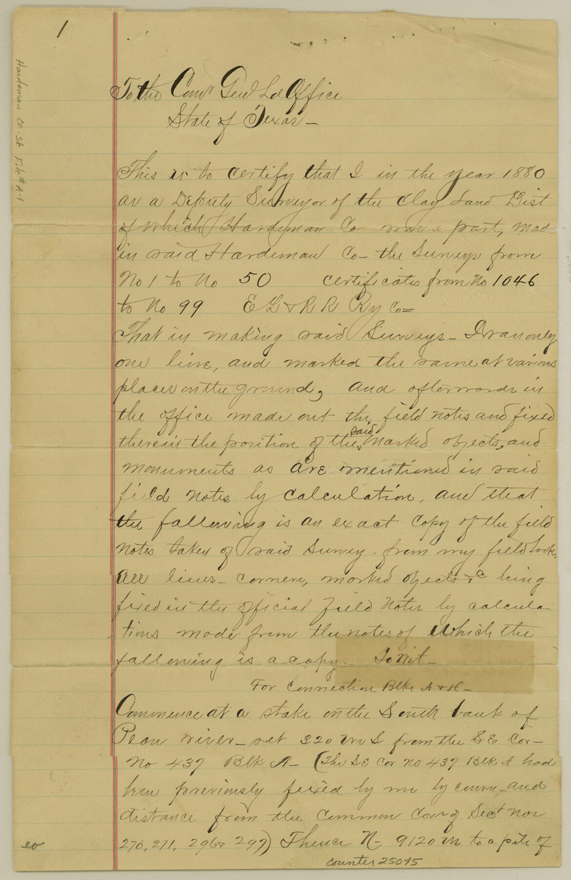
[Statement of T. W. Robinson regarding connections from no. 1 to no. 50]
-
Map/Doc
25045
-
Collection
General Map Collection
-
Object Dates
1891/2/18 (Survey Date)
1891/2/18 (Creation Date)
-
People and Organizations
T. Windsor Robinson (Surveyor/Engineer)
-
Counties
Hardeman
-
Subjects
Surveying Sketch File
-
Height x Width
12.7 x 8.2 inches
32.3 x 20.8 cm
-
Medium
paper, manuscript
-
Features
Pease River
Part of: General Map Collection

Webb County Rolled Sketch 36

Print $20.00
- Digital $50.00
Webb County Rolled Sketch 36
1940
Size 12.8 x 24.2 inches
Map/Doc 8191
Austin County Sketch File 2

Print $4.00
- Digital $50.00
Austin County Sketch File 2
Size 8.2 x 6.3 inches
Map/Doc 13855
Flight Mission No. DAH-9M, Frame 82, Orange County

Print $20.00
- Digital $50.00
Flight Mission No. DAH-9M, Frame 82, Orange County
1953
Size 18.4 x 22.4 inches
Map/Doc 86846
Newton County Rolled Sketch 16

Print $20.00
- Digital $50.00
Newton County Rolled Sketch 16
Size 30.5 x 21.9 inches
Map/Doc 6846
Mills County Working Sketch 12

Print $20.00
- Digital $50.00
Mills County Working Sketch 12
1923
Size 22.1 x 26.3 inches
Map/Doc 71042
Liberty County Working Sketch 85

Print $20.00
- Digital $50.00
Liberty County Working Sketch 85
1987
Size 27.2 x 28.3 inches
Map/Doc 70545

Knox County Rolled Sketch 22

Print $20.00
- Digital $50.00
Knox County Rolled Sketch 22
1968
Size 25.4 x 37.6 inches
Map/Doc 6562
Harris County Working Sketch 88

Print $20.00
- Digital $50.00
Harris County Working Sketch 88
1972
Size 30.3 x 38.4 inches
Map/Doc 65980

Montgomery County Rolled Sketch 16

Print $20.00
- Digital $50.00
Montgomery County Rolled Sketch 16
Size 28.5 x 26.6 inches
Map/Doc 6804
You may also like
Schleicher County Working Sketch 6

Print $20.00
- Digital $50.00
Schleicher County Working Sketch 6
1917
Size 24.6 x 19.3 inches
Map/Doc 63808
[T. & P. RR. Co. Blocks 54, 55 and 76, Townships 1 and 2]
![89888, [T. & P. RR. Co. Blocks 54, 55 and 76, Townships 1 and 2], Twichell Survey Records](https://historictexasmaps.com/wmedia_w700/maps/89888-1.tif.jpg)
Print $20.00
- Digital $50.00
[T. & P. RR. Co. Blocks 54, 55 and 76, Townships 1 and 2]
Size 44.2 x 36.2 inches
Map/Doc 89888
"G" Sketch from Gaines County

Print $20.00
- Digital $50.00
"G" Sketch from Gaines County
1902
Size 31.7 x 21.7 inches
Map/Doc 90839
Map of the United States

Print $20.00
- Digital $50.00
Map of the United States
1851
Size 24.7 x 26.0 inches
Map/Doc 96632
Starr County Working Sketch 29

Print $20.00
- Digital $50.00
Starr County Working Sketch 29
2007
Size 28.6 x 34.0 inches
Map/Doc 87208
Jack County Sketch File 15

Print $4.00
- Digital $50.00
Jack County Sketch File 15
1880
Size 7.3 x 13.7 inches
Map/Doc 27545
Floyd County Sketch File 20

Print $4.00
- Digital $50.00
Floyd County Sketch File 20
1914
Size 14.5 x 8.9 inches
Map/Doc 22772
Webb County Sketch File 25

Print $20.00
- Digital $50.00
Webb County Sketch File 25
1936
Size 18.2 x 30.7 inches
Map/Doc 12639
Flight Mission No. BRE-1P, Frame 120, Nueces County

Print $20.00
- Digital $50.00
Flight Mission No. BRE-1P, Frame 120, Nueces County
1956
Size 18.6 x 22.8 inches
Map/Doc 86686
Preliminary Chart No. 31 of the Sea Coast of the United States from Galveston Bay to Matagorda Bay, Texas

Print $20.00
- Digital $50.00
Preliminary Chart No. 31 of the Sea Coast of the United States from Galveston Bay to Matagorda Bay, Texas
1857
Size 23.3 x 28.1 inches
Map/Doc 69950
South Part of Webb County

Print $40.00
- Digital $50.00
South Part of Webb County
1984
Size 44.1 x 64.9 inches
Map/Doc 95670
