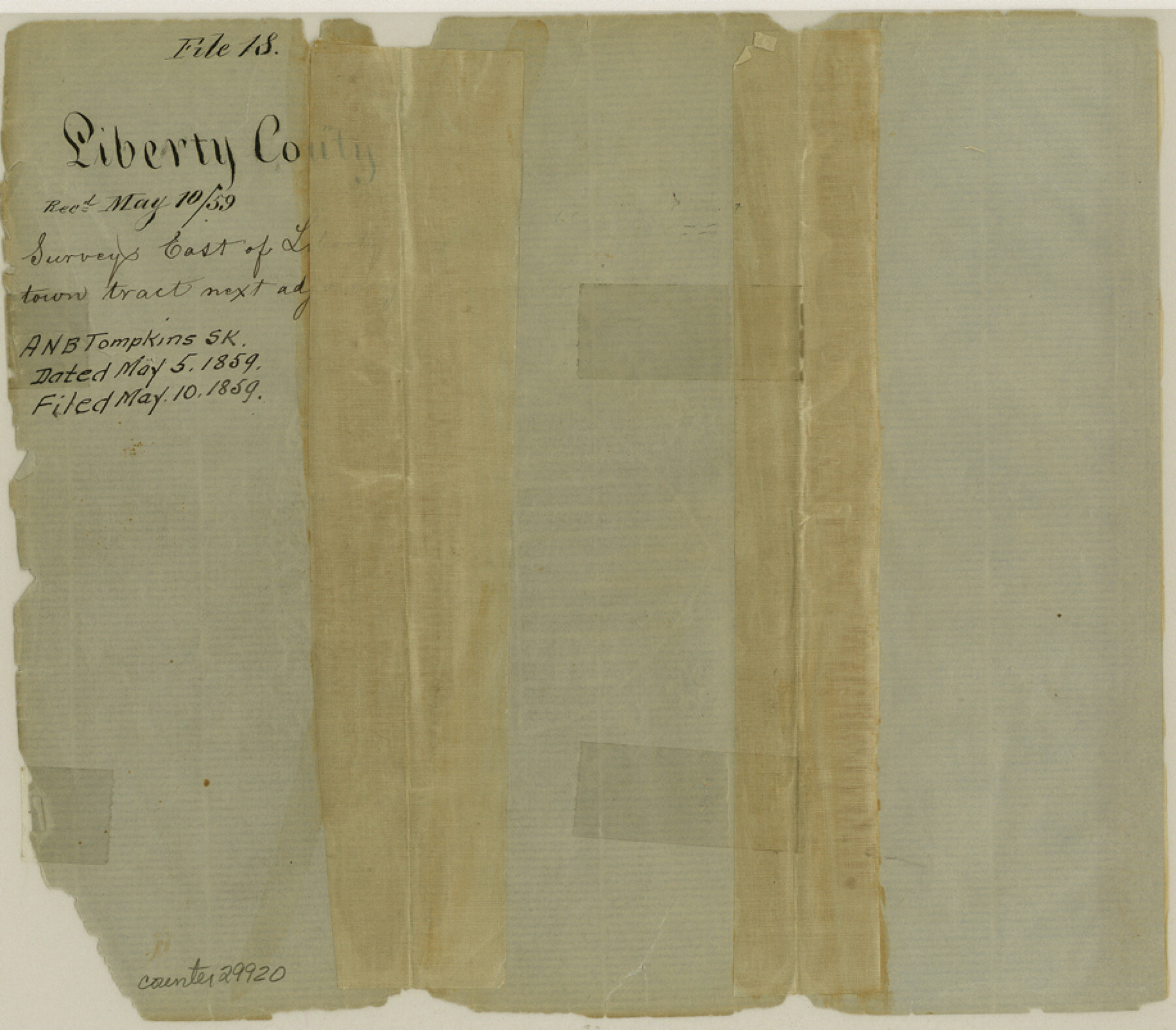
Liberty County Sketch File 18
[Sketch of surveys east of Liberty town tract]
-
Map/Doc
29920
-
Collection
General Map Collection
-
Object Dates
5/5/1859 (Creation Date)
5/10/1859 (File Date)
-
People and Organizations
A.N.B. Tompkins (Surveyor/Engineer)
-
Counties
Liberty
-
Subjects
Surveying Sketch File
-
Height x Width
8.0 x 9.2 inches
20.3 x 23.4 cm
-
Medium
paper, manuscript
Part of: General Map Collection
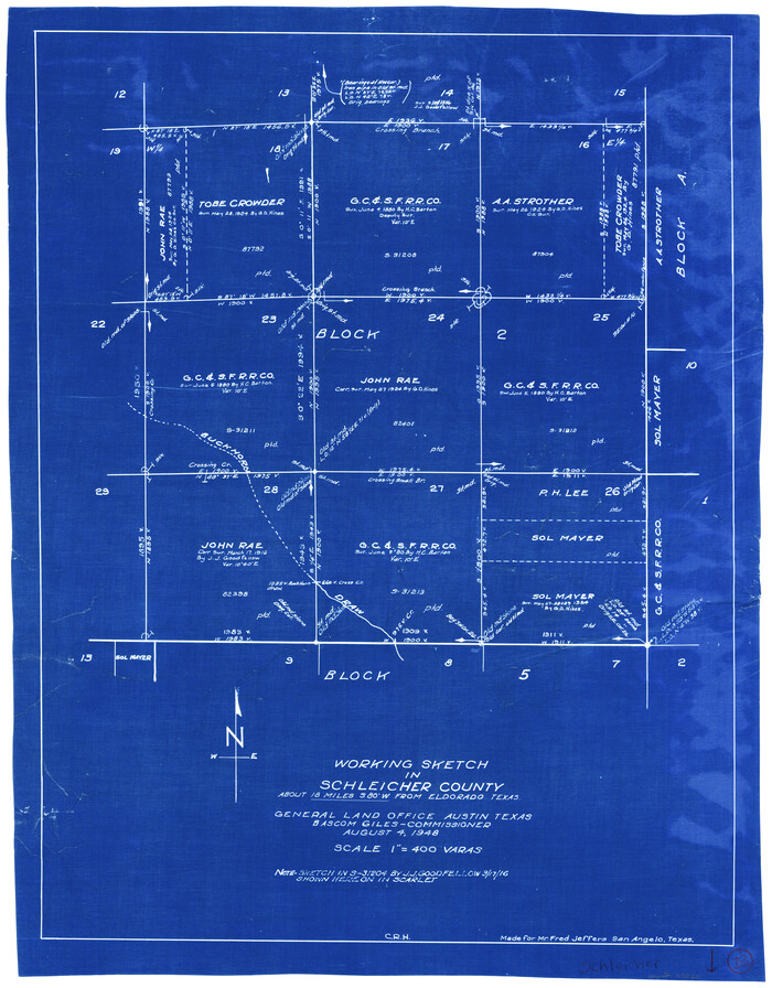
Schleicher County Working Sketch 18
Print $20.00
- Digital $50.00
Schleicher County Working Sketch 18
1948
Size 28.4 x 22.1 inches
Map/Doc 63820
Brazoria County Rolled Sketch 48
Print $20.00
- Digital $50.00
Brazoria County Rolled Sketch 48
1952
Size 28.6 x 41.3 inches
Map/Doc 5181
Andrews County Sketch File 1

Print $6.00
- Digital $50.00
Andrews County Sketch File 1
Size 9.0 x 13.6 inches
Map/Doc 12818
Nueces County Sketch File 18

Print $4.00
- Digital $50.00
Nueces County Sketch File 18
1874
Size 10.2 x 7.2 inches
Map/Doc 32549
Sutton County Rolled Sketch 67

Print $20.00
- Digital $50.00
Sutton County Rolled Sketch 67
Size 25.4 x 37.3 inches
Map/Doc 7902
Flight Mission No. CUG-2P, Frame 12, Kleberg County

Print $20.00
- Digital $50.00
Flight Mission No. CUG-2P, Frame 12, Kleberg County
1956
Size 18.6 x 22.1 inches
Map/Doc 86184
Frio County Rolled Sketch 6

Print $20.00
- Digital $50.00
Frio County Rolled Sketch 6
1938
Size 42.7 x 32.6 inches
Map/Doc 76019
Maps of Gulf Intracoastal Waterway, Texas - Sabine River to the Rio Grande and connecting waterways including ship channels

Print $20.00
- Digital $50.00
Maps of Gulf Intracoastal Waterway, Texas - Sabine River to the Rio Grande and connecting waterways including ship channels
1966
Size 14.5 x 22.3 inches
Map/Doc 61949
Flight Mission No. DCL-5C, Frame 76, Kenedy County

Print $20.00
- Digital $50.00
Flight Mission No. DCL-5C, Frame 76, Kenedy County
1943
Size 18.4 x 22.4 inches
Map/Doc 85859
Upshur County Working Sketch 15, revised

Print $20.00
- Digital $50.00
Upshur County Working Sketch 15, revised
1996
Size 43.3 x 37.4 inches
Map/Doc 78217
Sutton County Rolled Sketch 49

Print $20.00
- Digital $50.00
Sutton County Rolled Sketch 49
1947
Size 19.2 x 19.3 inches
Map/Doc 7890
Township No. 5 South Range No. 16 West of the Indian Meridian

Print $4.00
- Digital $50.00
Township No. 5 South Range No. 16 West of the Indian Meridian
1875
Size 17.8 x 22.6 inches
Map/Doc 75163
You may also like
A.R. Roessler's Latest Map of the State of Texas Exhibiting Mineral and Agricultural Districts, Post Offices and Mailroutes, Railroads projected and finished, Timber, Prairie, Swamp Lands, etc. etc. etc.

Print $20.00
A.R. Roessler's Latest Map of the State of Texas Exhibiting Mineral and Agricultural Districts, Post Offices and Mailroutes, Railroads projected and finished, Timber, Prairie, Swamp Lands, etc. etc. etc.
1874
Size 39.7 x 46.8 inches
Map/Doc 76254
Sketch in Castro County

Print $2.00
- Digital $50.00
Sketch in Castro County
1888
Size 7.8 x 7.9 inches
Map/Doc 90388
Intracoastal Waterway - Laguna Madre - Chubby Island to Stover Point including the Arroyo Colorado, Texas

Print $20.00
- Digital $50.00
Intracoastal Waterway - Laguna Madre - Chubby Island to Stover Point including the Arroyo Colorado, Texas
1976
Size 15.6 x 43.8 inches
Map/Doc 75900
Map of Schleicher County

Print $20.00
- Digital $50.00
Map of Schleicher County
1887
Size 21.4 x 30.1 inches
Map/Doc 4021
Mason County Working Sketch 14

Print $20.00
- Digital $50.00
Mason County Working Sketch 14
1959
Size 28.6 x 23.3 inches
Map/Doc 70850
Bailey County Working Sketch 2

Print $20.00
- Digital $50.00
Bailey County Working Sketch 2
1920
Size 17.8 x 16.2 inches
Map/Doc 67589
Flight Mission No. CRC-4R, Frame 72, Chambers County

Print $20.00
- Digital $50.00
Flight Mission No. CRC-4R, Frame 72, Chambers County
1956
Size 18.8 x 22.4 inches
Map/Doc 84876
Intracoastal Waterway in Texas - Corpus Christi to Point Isabel including Arroyo Colorado to Mo. Pac. R.R. Bridge Near Harlingen

Print $20.00
- Digital $50.00
Intracoastal Waterway in Texas - Corpus Christi to Point Isabel including Arroyo Colorado to Mo. Pac. R.R. Bridge Near Harlingen
1933
Size 27.9 x 40.8 inches
Map/Doc 61862
Flight Mission No. BRE-1P, Frame 105, Nueces County

Print $20.00
- Digital $50.00
Flight Mission No. BRE-1P, Frame 105, Nueces County
1956
Size 18.4 x 22.2 inches
Map/Doc 86676
Hudspeth County Sketch File 4a

Print $22.00
- Digital $50.00
Hudspeth County Sketch File 4a
1858
Size 16.4 x 14.3 inches
Map/Doc 26889
Travis County Sketch File 48

Print $6.00
- Digital $50.00
Travis County Sketch File 48
1940
Size 11.4 x 8.8 inches
Map/Doc 38377
Motley County Sketch File 35 (S)

Print $20.00
- Digital $50.00
Motley County Sketch File 35 (S)
Size 17.8 x 18.5 inches
Map/Doc 42150