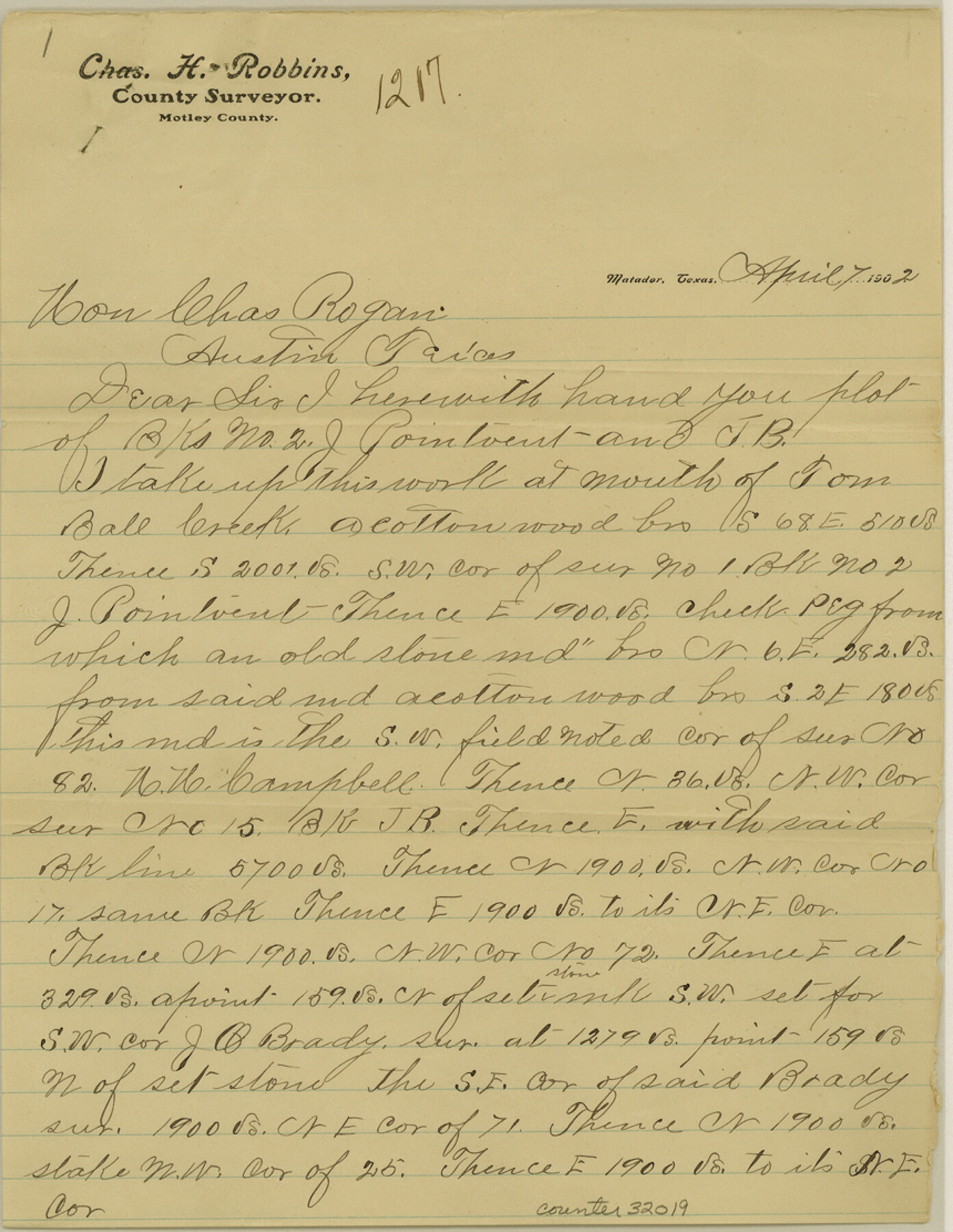
Motley County Sketch File 9 (N)
[Survey report by Chas. H. Robbins]
-
Map/Doc
32019
-
Collection
General Map Collection
-
Object Dates
4/7/1902 (Creation Date)
4/12/1902 (File Date)
4/7/1902 (Correspondence Date)
-
People and Organizations
Charles H. Robbins (Surveyor/Engineer)
-
Counties
Motley
-
Subjects
Surveying Sketch File
-
Height x Width
11.1 x 8.6 inches
28.2 x 21.8 cm
-
Medium
paper, manuscript
-
Features
Tom Ball Creek
Part of: General Map Collection
Map of Liberty County Texas

Print $20.00
- Digital $50.00
Map of Liberty County Texas
1895
Size 29.7 x 29.4 inches
Map/Doc 3811
Flight Mission No. BRA-7M, Frame 36, Jefferson County

Print $20.00
- Digital $50.00
Flight Mission No. BRA-7M, Frame 36, Jefferson County
1953
Size 18.7 x 22.3 inches
Map/Doc 85487
Dallas County Boundary File 5

Print $120.00
- Digital $50.00
Dallas County Boundary File 5
Size 11.5 x 72.2 inches
Map/Doc 52160
Shackelford County Rolled Sketch 2

Print $40.00
- Digital $50.00
Shackelford County Rolled Sketch 2
Size 18.9 x 51.9 inches
Map/Doc 75935

Calhoun County Rolled Sketch 30

Print $20.00
- Digital $50.00
Calhoun County Rolled Sketch 30
1974
Size 18.5 x 27.5 inches
Map/Doc 5496
Map of Stephens Buchanan County north of the Clearfork of the Brazos River, Young- the balance Milam- Land- District

Print $20.00
- Digital $50.00
Map of Stephens Buchanan County north of the Clearfork of the Brazos River, Young- the balance Milam- Land- District
1859
Size 24.4 x 19.6 inches
Map/Doc 4052
Hutchinson County Sketch File 4a

Print $7.00
- Digital $50.00
Hutchinson County Sketch File 4a
Size 25.9 x 43.8 inches
Map/Doc 10625
Fort Bend Co.

Print $20.00
- Digital $50.00
Fort Bend Co.
1931
Size 40.2 x 41.8 inches
Map/Doc 95500
Comal County Sketch File 8 1/2

Print $22.00
- Digital $50.00
Comal County Sketch File 8 1/2
1858
Size 9.2 x 7.4 inches
Map/Doc 19015
Upshur County Sketch File 20

Print $4.00
- Digital $50.00
Upshur County Sketch File 20
1873
Size 5.7 x 8.3 inches
Map/Doc 38792
Sutton County Sketch File E2

Print $20.00
- Digital $50.00
Sutton County Sketch File E2
Size 16.8 x 19.0 inches
Map/Doc 12397
You may also like
Crane County Map of Unsurveyed School Lands for Bob Reid's Application to Lease

Print $40.00
- Digital $50.00
Crane County Map of Unsurveyed School Lands for Bob Reid's Application to Lease
1946
Size 49.0 x 51.3 inches
Map/Doc 90466
[Beaumont, Sour Lake and Western Ry. Right of Way and Alignment - Frisco]
![64132, [Beaumont, Sour Lake and Western Ry. Right of Way and Alignment - Frisco], General Map Collection](https://historictexasmaps.com/wmedia_w700/maps/64132.tif.jpg)
Print $20.00
- Digital $50.00
[Beaumont, Sour Lake and Western Ry. Right of Way and Alignment - Frisco]
1910
Size 19.9 x 46.1 inches
Map/Doc 64132
La Salle County Rolled Sketch 6

Print $40.00
- Digital $50.00
La Salle County Rolled Sketch 6
1941
Size 43.0 x 66.0 inches
Map/Doc 10738
No. 1 - Survey for a road from the Brazo Santiago to the Rio Grande

Print $20.00
- Digital $50.00
No. 1 - Survey for a road from the Brazo Santiago to the Rio Grande
1847
Size 18.4 x 27.3 inches
Map/Doc 72875
Donley County Sketch File B3

Print $20.00
- Digital $50.00
Donley County Sketch File B3
1918
Size 22.0 x 15.0 inches
Map/Doc 11373
Travis County Sketch File 12a

Print $5.00
- Digital $50.00
Travis County Sketch File 12a
1859
Size 7.9 x 9.1 inches
Map/Doc 38308

Liberty County Sketch File 45

Print $4.00
- Digital $50.00
Liberty County Sketch File 45
Size 7.8 x 10.1 inches
Map/Doc 30003
Ector County Working Sketch 26

Print $20.00
- Digital $50.00
Ector County Working Sketch 26
1961
Size 30.8 x 43.6 inches
Map/Doc 68869
Oldham County Working Sketch Graphic Index

Print $40.00
- Digital $50.00
Oldham County Working Sketch Graphic Index
1925
Size 42.2 x 51.7 inches
Map/Doc 76657
Howard County Working Sketch 8

Print $20.00
- Digital $50.00
Howard County Working Sketch 8
1956
Size 25.3 x 31.3 inches
Map/Doc 66275
McMullen County Sketch File 36

Print $8.00
- Digital $50.00
McMullen County Sketch File 36
Size 4.8 x 8.2 inches
Map/Doc 31406