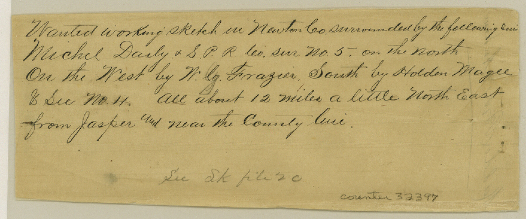
Newton County Sketch File 20a
[Office sketch of the John McGee survey and surrounding area northwest of Newton]
-
Map/Doc
32397
-
Collection
General Map Collection
-
People and Organizations
E. Schutze (Draftsman)
-
Counties
Newton Jasper
-
Subjects
Surveying Sketch File
-
Height x Width
3.7 x 8.8 inches
9.4 x 22.4 cm
-
Medium
paper, manuscript
Part of: General Map Collection
Jasper County Rolled Sketch 7B

Print $20.00
- Digital $50.00
Jasper County Rolled Sketch 7B
Size 19.7 x 11.6 inches
Map/Doc 6355
Dallas County Rolled Sketch 6

Print $20.00
- Digital $50.00
Dallas County Rolled Sketch 6
1983
Size 31.7 x 37.5 inches
Map/Doc 8769
Pecos County Sketch File 84

Print $4.00
- Digital $50.00
Pecos County Sketch File 84
1944
Size 11.2 x 8.8 inches
Map/Doc 33953
Caldwell County Sketch File 4

Print $8.00
- Digital $50.00
Caldwell County Sketch File 4
Size 8.8 x 6.9 inches
Map/Doc 35831
[Atchison, Topeka & Santa Fe from Paisano to south of Plata]
![64709, [Atchison, Topeka & Santa Fe from Paisano to south of Plata], General Map Collection](https://historictexasmaps.com/wmedia_w700/maps/64709.tif.jpg)
Print $40.00
- Digital $50.00
[Atchison, Topeka & Santa Fe from Paisano to south of Plata]
Size 32.3 x 120.8 inches
Map/Doc 64709
Eastland County Boundary File 26a

Print $32.00
- Digital $50.00
Eastland County Boundary File 26a
Size 12.7 x 8.1 inches
Map/Doc 52813
Outer Continental Shelf Leasing Maps (Texas Offshore Operations)

Print $20.00
- Digital $50.00
Outer Continental Shelf Leasing Maps (Texas Offshore Operations)
Size 17.0 x 18.4 inches
Map/Doc 75847
[Surveys on Cibolo Creek]
![363, [Surveys on Cibolo Creek], General Map Collection](https://historictexasmaps.com/wmedia_w700/maps/363.tif.jpg)
Print $2.00
- Digital $50.00
[Surveys on Cibolo Creek]
Size 7.4 x 6.7 inches
Map/Doc 363
Upton County Rolled Sketch 41

Print $20.00
- Digital $50.00
Upton County Rolled Sketch 41
Size 27.4 x 40.8 inches
Map/Doc 8080
Bastrop County Sketch File 4

Print $4.00
- Digital $50.00
Bastrop County Sketch File 4
1873
Size 12.7 x 7.9 inches
Map/Doc 14046
Runnels County Rolled Sketch C

Print $20.00
- Digital $50.00
Runnels County Rolled Sketch C
1892
Size 16.0 x 21.0 inches
Map/Doc 7541
1883 Map of the Texas & Pacific R-Y Reserve

Print $40.00
- Digital $50.00
1883 Map of the Texas & Pacific R-Y Reserve
1883
Size 42.2 x 86.4 inches
Map/Doc 2236
You may also like
Brazoria County Working Sketch 46

Print $40.00
- Digital $50.00
Brazoria County Working Sketch 46
1988
Size 37.3 x 48.7 inches
Map/Doc 67531
Bexar County Rolled Sketch 4B

Print $20.00
- Digital $50.00
Bexar County Rolled Sketch 4B
1989
Size 24.3 x 36.7 inches
Map/Doc 5139
Erath County Working Sketch 3

Print $20.00
- Digital $50.00
Erath County Working Sketch 3
1919
Size 17.6 x 17.6 inches
Map/Doc 69084
Bandera County

Print $40.00
- Digital $50.00
Bandera County
1947
Size 33.9 x 54.9 inches
Map/Doc 73075
[Sutton County School Land and vicinity]
![92477, [Sutton County School Land and vicinity], Twichell Survey Records](https://historictexasmaps.com/wmedia_w700/maps/92477-1.tif.jpg)
Print $20.00
- Digital $50.00
[Sutton County School Land and vicinity]
Size 21.0 x 34.3 inches
Map/Doc 92477
Plan of the City of Galveston, Texas

Print $20.00
- Digital $50.00
Plan of the City of Galveston, Texas
1845
Size 18.3 x 27.4 inches
Map/Doc 62968
Wood County Sketch File 13

Print $24.00
- Digital $50.00
Wood County Sketch File 13
1866
Size 12.5 x 7.6 inches
Map/Doc 40668
Marble Falls City, Burnet County, Texas

Print $20.00
- Digital $50.00
Marble Falls City, Burnet County, Texas
1890
Size 26.6 x 20.5 inches
Map/Doc 4830
Blanco County Sketch File 23

Print $16.00
- Digital $50.00
Blanco County Sketch File 23
1887
Size 8.7 x 14.1 inches
Map/Doc 14606
Upshur County Rolled Sketch 1

Print $40.00
- Digital $50.00
Upshur County Rolled Sketch 1
1953
Size 50.2 x 44.7 inches
Map/Doc 10298
Frio County Working Sketch 23

Print $20.00
- Digital $50.00
Frio County Working Sketch 23
1992
Size 27.6 x 35.4 inches
Map/Doc 69297
General Highway Map, Jackson County, Texas

Print $20.00
General Highway Map, Jackson County, Texas
1940
Size 18.3 x 24.8 inches
Map/Doc 79140