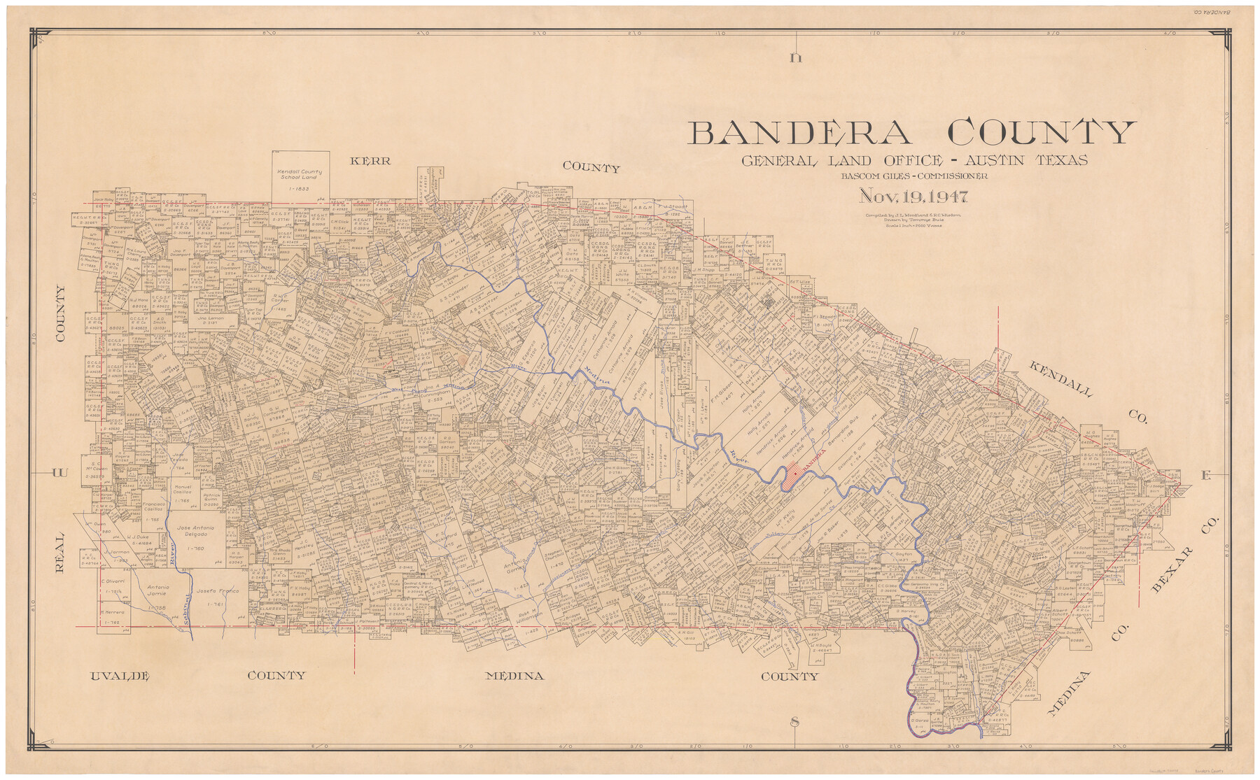
Bandera County
-
Map/Doc
73075
-
Collection
General Map Collection
-
Object Dates
1947/11/19 (Creation Date)
-
People and Organizations
Texas General Land Office (Publisher)
Tommye Buie (Draftsman)
Bascom Giles (GLO Commissioner)
R.C. Wisdom (Compiler)
J.L. Woodland (Compiler)
-
Counties
Bandera
-
Subjects
County
-
Height x Width
33.9 x 54.9 inches
86.1 x 139.4 cm
-
Comments
Note on reverse side: "Compilation completed November 19, 1947. Inking completed August 18, 1948. Tracing completed October 14, 1948. Placed in official use October 18, 1948."
-
Features
Williams Creek
Red Bluff Creek
Indian Creek
San Julian Creek
Bear Creek
Hicks Creek
Medina River
Bruin Creek
Verde Creek
Commissioners Creek
Thomas Creek
Wallace Creek
Hondo Creek
Secco Creek
Cañon Creek
Sabinal River
Bandera Creek
Masons Creek
Pipe Creek
Privilege Creek
Bandera
West Prong of Medina River
Part of: General Map Collection
Flight Mission No. DQO-2K, Frame 93, Galveston County

Print $20.00
- Digital $50.00
Flight Mission No. DQO-2K, Frame 93, Galveston County
1952
Size 18.8 x 22.4 inches
Map/Doc 85020
Starr County Sketch File 48

Print $20.00
- Digital $50.00
Starr County Sketch File 48
1950
Size 22.3 x 10.8 inches
Map/Doc 12345
Flight Mission No. BRA-3M, Frame 118, Jefferson County

Print $20.00
- Digital $50.00
Flight Mission No. BRA-3M, Frame 118, Jefferson County
1953
Size 18.6 x 22.3 inches
Map/Doc 85392
Williamson County Sketch File 5a

Print $4.00
- Digital $50.00
Williamson County Sketch File 5a
1849
Size 12.8 x 8.1 inches
Map/Doc 40312
Railroad Track Map, H&TCRRCo., Falls County, Texas

Print $4.00
- Digital $50.00
Railroad Track Map, H&TCRRCo., Falls County, Texas
1918
Size 11.4 x 18.7 inches
Map/Doc 62849
Harris County Working Sketch 55

Print $20.00
- Digital $50.00
Harris County Working Sketch 55
1950
Size 19.3 x 25.2 inches
Map/Doc 65947
Erath County Sketch File 13

Print $4.00
- Digital $50.00
Erath County Sketch File 13
1871
Size 7.9 x 6.6 inches
Map/Doc 22285
Matagorda County Rolled Sketch 26

Print $20.00
- Digital $50.00
Matagorda County Rolled Sketch 26
1950
Size 39.5 x 42.1 inches
Map/Doc 9479
Real County Sketch File 6

Print $20.00
- Digital $50.00
Real County Sketch File 6
1931
Size 17.3 x 19.6 inches
Map/Doc 12229
Kendall County Boundary File 1

Print $6.00
- Digital $50.00
Kendall County Boundary File 1
Size 14.2 x 8.7 inches
Map/Doc 55743
Baylor County Rolled Sketch BT

Print $20.00
- Digital $50.00
Baylor County Rolled Sketch BT
1916
Size 21.4 x 24.0 inches
Map/Doc 5131
Red River County Sketch File 25

Print $20.00
- Digital $50.00
Red River County Sketch File 25
Size 26.0 x 38.9 inches
Map/Doc 10586
You may also like
Aransas County Rolled Sketch 34

Print $42.00
- Digital $50.00
Aransas County Rolled Sketch 34
2004
Size 24.5 x 36.5 inches
Map/Doc 83637
Galveston County NRC Article 33.136 Sketch 55

Print $78.00
- Digital $50.00
Galveston County NRC Article 33.136 Sketch 55
2009
Size 23.0 x 34.3 inches
Map/Doc 94580
General Highway Map, Gonzales County, Texas

Print $20.00
General Highway Map, Gonzales County, Texas
1961
Size 18.2 x 24.7 inches
Map/Doc 79482
[Old Coastal Chart showing Brazo Chico, Brazo de Santiago and Rio Bravo del Norte passes with depth readings]
![4661, [Old Coastal Chart showing Brazo Chico, Brazo de Santiago and Rio Bravo del Norte passes with depth readings], General Map Collection](https://historictexasmaps.com/wmedia_w700/maps/4661-1.tif.jpg)
Print $20.00
- Digital $50.00
[Old Coastal Chart showing Brazo Chico, Brazo de Santiago and Rio Bravo del Norte passes with depth readings]
1837
Size 25.7 x 39.3 inches
Map/Doc 4661
Montague County Working Sketch 41

Print $40.00
- Digital $50.00
Montague County Working Sketch 41
1923
Size 43.0 x 66.1 inches
Map/Doc 65349

Uvalde County Rolled Sketch 19

Print $20.00
- Digital $50.00
Uvalde County Rolled Sketch 19
Size 21.9 x 20.2 inches
Map/Doc 8103
Newton County Rolled Sketch 25

Print $20.00
- Digital $50.00
Newton County Rolled Sketch 25
1893
Size 22.3 x 18.6 inches
Map/Doc 6852
Brazos County Working Sketch 7

Print $20.00
- Digital $50.00
Brazos County Working Sketch 7
1981
Size 12.1 x 33.1 inches
Map/Doc 67482
Current Miscellaneous File 9

Print $66.00
- Digital $50.00
Current Miscellaneous File 9
Size 6.5 x 8.2 inches
Map/Doc 73741
Atascosa County Working Sketch 9

Print $20.00
- Digital $50.00
Atascosa County Working Sketch 9
1914
Size 16.5 x 14.6 inches
Map/Doc 67205
Presidio County Rolled Sketch 46

Print $20.00
- Digital $50.00
Presidio County Rolled Sketch 46
1908
Size 19.0 x 15.5 inches
Map/Doc 7342