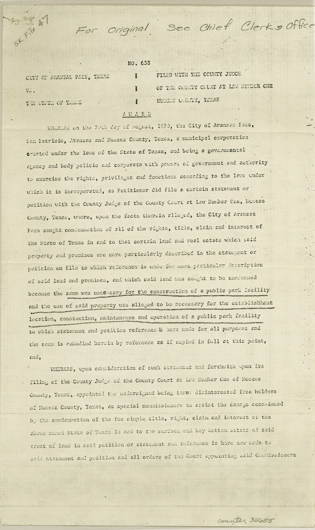
Nueces County Sketch File 47
[Judgement and field notes - City of Aransas Pass vs. The State of Texas]
- 
                          Map/Doc32655
- 
                            CollectionGeneral Map Collection
- 
                            Object Dates8/17/1970 (File Date)
- 
                            People and OrganizationsFelix R. Hillmer (Surveyor/Engineer)
- 
                            CountiesNueces
- 
                            SubjectsSurveying Sketch File
- 
                            Height x Width14.3 x 8.5 inches36.3 x 21.6 cm
- 
                            Mediumphotostat
- 
                            FeaturesAransas PassCorpus Christi BayRedfish Bay
Part of: General Map Collection
            Kinney County Working Sketch 34


                                            Print $4.00                    
                                             -                         Digital $50.00                                    
                Kinney County Working Sketch 34
1963
Size 23.0 x 26.9 inches
                                Map/Doc 70216
            
            Presidio County Sketch File 64


                                            Print $20.00                    
                                             -                         Digital $50.00                                    
                Presidio County Sketch File 64
1938
Size 16.5 x 26.5 inches
                                Map/Doc 11719
            
            North Sulphur River, Kinsing Sheet


                                            Print $20.00                    
                                             -                         Digital $50.00                                    
                North Sulphur River, Kinsing Sheet
1925
Size 18.6 x 23.4 inches
                                Map/Doc 78331
            
            Presidio County Sketch File 58a


                                            Print $14.00                    
                                             -                         Digital $50.00                                    
                Presidio County Sketch File 58a
1980
Size 11.2 x 8.8 inches
                                Map/Doc 34628
            
            Kerr County Sketch File 4


                                            Print $10.00                    
                                             -                         Digital $50.00                                    
                Kerr County Sketch File 4
1873
Size 8.1 x 7.7 inches
                                Map/Doc 28860
            
            Brazoria County Working Sketch 3


                                            Print $20.00                    
                                             -                         Digital $50.00                                    
                Brazoria County Working Sketch 3
1915
Size 13.0 x 11.1 inches
                                Map/Doc 67488
            
            Texas Panhandle East Boundary Line


                                            Print $40.00                    
                                             -                         Digital $50.00                                    
                Texas Panhandle East Boundary Line
1898
Size 65.3 x 10.0 inches
                                Map/Doc 1702
            
            [Cotton Belt, St. Louis Southwestern Railway of Texas, Alignment through Smith County]
            
                                    ![64376, [Cotton Belt, St. Louis Southwestern Railway of Texas, Alignment through Smith County], General Map Collection](https://historictexasmaps.com/wmedia_w700/maps/64376.tif.jpg) 


    ![64376, [Cotton Belt, St. Louis Southwestern Railway of Texas, Alignment through Smith County], General Map Collection](https://historictexasmaps.com/wmedia_w700/maps/64376.tif.jpg) 
                                
            
                                            Print $20.00                    
                                             -                         Digital $50.00                                    
                [Cotton Belt, St. Louis Southwestern Railway of Texas, Alignment through Smith County]
1903
Size 22.0 x 29.3 inches
                                Map/Doc 64376
            
            Young County Working Sketch 10


                                            Print $20.00                    
                                             -                         Digital $50.00                                    
                Young County Working Sketch 10
1921
Size 24.4 x 34.4 inches
                                Map/Doc 62033
            
            Bee County Working Sketch 33


                                            Print $20.00                    
                                             -                         Digital $50.00                                    
                Bee County Working Sketch 33
1980
Size 32.0 x 28.2 inches
                                Map/Doc 67284
            
            Hopkins County Sketch File 10


                                            Print $4.00                    
                                             -                         Digital $50.00                                    
                Hopkins County Sketch File 10
1856
Size 9.1 x 8.2 inches
                                Map/Doc 26700
            You may also like
            Texas Intracoastal Waterway, Aransas Bay to Aransas Pass


                                            Print $20.00                    
                                             -                         Digital $50.00                                    
                Texas Intracoastal Waterway, Aransas Bay to Aransas Pass
1962
Size 26.8 x 38.7 inches
                                Map/Doc 73438
            
            Louisiana and Texas Intracoastal Waterway - Entrance near Port O'Connor, Texas, Survey of September, 1940


                                            Print $20.00                    
                                             -                         Digital $50.00                                    
                Louisiana and Texas Intracoastal Waterway - Entrance near Port O'Connor, Texas, Survey of September, 1940
1940
Size 31.2 x 41.5 inches
                                Map/Doc 61822
            
            [William T. Brewer, John R. Taylor, M. McDonald, W. N. Raymond, and surrounding surveys]
            
                                    ![91031, [William T. Brewer, John R. Taylor, M. McDonald, W. N. Raymond, and surrounding surveys], Twichell Survey Records](https://historictexasmaps.com/wmedia_w700/maps/91031-1.tif.jpg) 


    ![91031, [William T. Brewer, John R. Taylor, M. McDonald, W. N. Raymond, and surrounding surveys], Twichell Survey Records](https://historictexasmaps.com/wmedia_w700/maps/91031-1.tif.jpg) 
                                
            
                                            Print $20.00                    
                                             -                         Digital $50.00                                    
                [William T. Brewer, John R. Taylor, M. McDonald, W. N. Raymond, and surrounding surveys]
Size 29.1 x 25.5 inches
                                Map/Doc 91031
            
            Zapata County Rolled Sketch 22


                                            Print $20.00                    
                                             -                         Digital $50.00                                    
                Zapata County Rolled Sketch 22
1958
Size 29.2 x 21.5 inches
                                Map/Doc 8317
            
            Preliminary Sketch of Galveston Bay, Texas


                                            Print $20.00                    
                                    
                Preliminary Sketch of Galveston Bay, Texas
1852
Size 22.6 x 18.3 inches
                                Map/Doc 79317
            
            Dimmit County Working Sketch 19


                                            Print $20.00                    
                                             -                         Digital $50.00                                    
                Dimmit County Working Sketch 19
1948
Size 27.4 x 23.3 inches
                                Map/Doc 68680
            
            Williamson County Sketch File 5a


                                            Print $4.00                    
                                             -                         Digital $50.00                                    
                Williamson County Sketch File 5a
1849
Size 12.8 x 8.1 inches
                                Map/Doc 40312
            
            Part of Matagorda Bay & Peninsula, Texas


                                            Print $40.00                    
                                             -                         Digital $50.00                                    
                Part of Matagorda Bay & Peninsula, Texas
1856
Size 31.8 x 51.4 inches
                                Map/Doc 69978
            
            Map of the Houston & Great Northern Railroad


                                            Print $40.00                    
                                             -                         Digital $50.00                                    
                Map of the Houston & Great Northern Railroad
1871
Size 26.6 x 48.4 inches
                                Map/Doc 64472
            
            Sutton County Rolled Sketch H


                                            Print $40.00                    
                                             -                         Digital $50.00                                    
                Sutton County Rolled Sketch H
Size 24.9 x 50.0 inches
                                Map/Doc 9973
            
            Ector County Working Sketch 24


                                            Print $40.00                    
                                             -                         Digital $50.00                                    
                Ector County Working Sketch 24
1961
Size 42.2 x 51.7 inches
                                Map/Doc 68867
            
            Flight Mission No. DQN-2K, Frame 74, Calhoun County


                                            Print $20.00                    
                                             -                         Digital $50.00                                    
                Flight Mission No. DQN-2K, Frame 74, Calhoun County
1953
Size 18.6 x 22.2 inches
                                Map/Doc 84266
             
                            