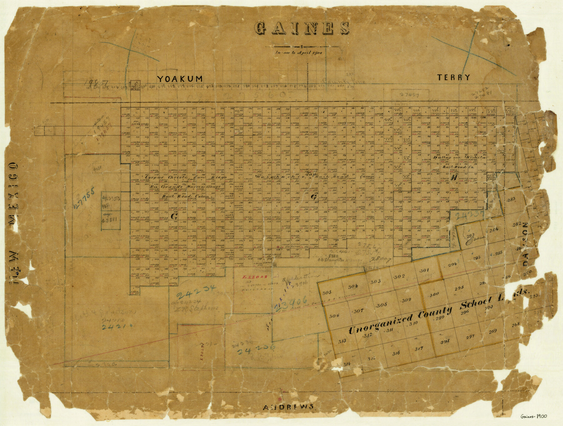
Gaines
-
Map/Doc
3571
-
Collection
General Map Collection
-
Object Dates
4/1900 (Creation Date)
-
Counties
Gaines
-
Subjects
County
-
Height x Width
22.3 x 29.0 inches
56.6 x 73.7 cm
-
Features
Salt Lake
Part of: General Map Collection
Trinity County Sketch File 34

Print $20.00
- Digital $50.00
Trinity County Sketch File 34
Size 15.9 x 20.3 inches
Map/Doc 12491
[Gonzales District]
![16837, [Gonzales District], General Map Collection](https://historictexasmaps.com/wmedia_w700/maps/16837.tif.jpg)
Print $20.00
- Digital $50.00
[Gonzales District]
1840
Size 42.8 x 37.0 inches
Map/Doc 16837
Crane County Sketch File 7

Print $6.00
- Digital $50.00
Crane County Sketch File 7
1886
Size 10.3 x 11.0 inches
Map/Doc 19567
Map of Dickens County

Print $20.00
- Digital $50.00
Map of Dickens County
1899
Size 41.1 x 37.7 inches
Map/Doc 4933
Cooke County Working Sketch 2

Print $20.00
- Digital $50.00
Cooke County Working Sketch 2
1925
Size 22.2 x 10.9 inches
Map/Doc 68239
Castro County Sketch File 17

Print $20.00
- Digital $50.00
Castro County Sketch File 17
1981
Size 14.8 x 25.7 inches
Map/Doc 11063
[Surveys in Austin's Colony along the Navasota River and Ten Mile Creek]
![80, [Surveys in Austin's Colony along the Navasota River and Ten Mile Creek], General Map Collection](https://historictexasmaps.com/wmedia_w700/maps/80.tif.jpg)
Print $20.00
- Digital $50.00
[Surveys in Austin's Colony along the Navasota River and Ten Mile Creek]
1821
Size 29.2 x 18.0 inches
Map/Doc 80
[Surveys along the Colorado River]
![61, [Surveys along the Colorado River], General Map Collection](https://historictexasmaps.com/wmedia_w700/maps/61.tif.jpg)
Print $20.00
- Digital $50.00
[Surveys along the Colorado River]
1841
Size 14.4 x 16.1 inches
Map/Doc 61
Dawson County Working Sketch 12

Print $20.00
- Digital $50.00
Dawson County Working Sketch 12
1951
Size 24.6 x 27.7 inches
Map/Doc 68556
Knox County Sketch File 14

Print $12.00
- Digital $50.00
Knox County Sketch File 14
1892
Size 11.1 x 8.5 inches
Map/Doc 29235
Frio County Working Sketch 9

Print $20.00
- Digital $50.00
Frio County Working Sketch 9
1949
Size 30.1 x 25.6 inches
Map/Doc 69283

You may also like
Carson County Boundary File 5b

Print $10.00
- Digital $50.00
Carson County Boundary File 5b
Size 11.7 x 8.6 inches
Map/Doc 51141
Webb County Rolled Sketch 23

Print $40.00
- Digital $50.00
Webb County Rolled Sketch 23
Size 138.8 x 38.2 inches
Map/Doc 10121
Swisher County Sketch File 19

Print $16.00
- Digital $50.00
Swisher County Sketch File 19
1913
Size 10.0 x 6.5 inches
Map/Doc 37662
Trinity County Sketch File 20

Print $20.00
- Digital $50.00
Trinity County Sketch File 20
Size 21.3 x 27.9 inches
Map/Doc 12485
Map of [Coleman County]
![3413, Map of [Coleman County], General Map Collection](https://historictexasmaps.com/wmedia_w700/maps/3413-1.tif.jpg)
Print $20.00
- Digital $50.00
Map of [Coleman County]
1878
Size 24.9 x 21.9 inches
Map/Doc 3413
Houston County Working Sketch 35, revised

Print $20.00
- Digital $50.00
Houston County Working Sketch 35, revised
1999
Size 27.8 x 31.6 inches
Map/Doc 66266
Map of the Republic of Mexico

Print $20.00
Map of the Republic of Mexico
1882
Size 33.0 x 47.4 inches
Map/Doc 76220
Henderson County Working Sketch 2

Print $20.00
- Digital $50.00
Henderson County Working Sketch 2
Size 29.1 x 30.0 inches
Map/Doc 66135
Dimmit County Working Sketch 43

Print $20.00
- Digital $50.00
Dimmit County Working Sketch 43
1978
Size 20.0 x 30.0 inches
Map/Doc 68704
Freestone County

Print $40.00
- Digital $50.00
Freestone County
1918
Size 48.4 x 41.6 inches
Map/Doc 66830
Flight Mission No. DCL-7C, Frame 17, Kenedy County

Print $20.00
- Digital $50.00
Flight Mission No. DCL-7C, Frame 17, Kenedy County
1943
Size 15.3 x 15.2 inches
Map/Doc 86009
Index to Titles, Field Notes, and Plats in the Spanish Archives

Index to Titles, Field Notes, and Plats in the Spanish Archives
1942
Size 17.5 x 10.1 inches
Map/Doc 94524