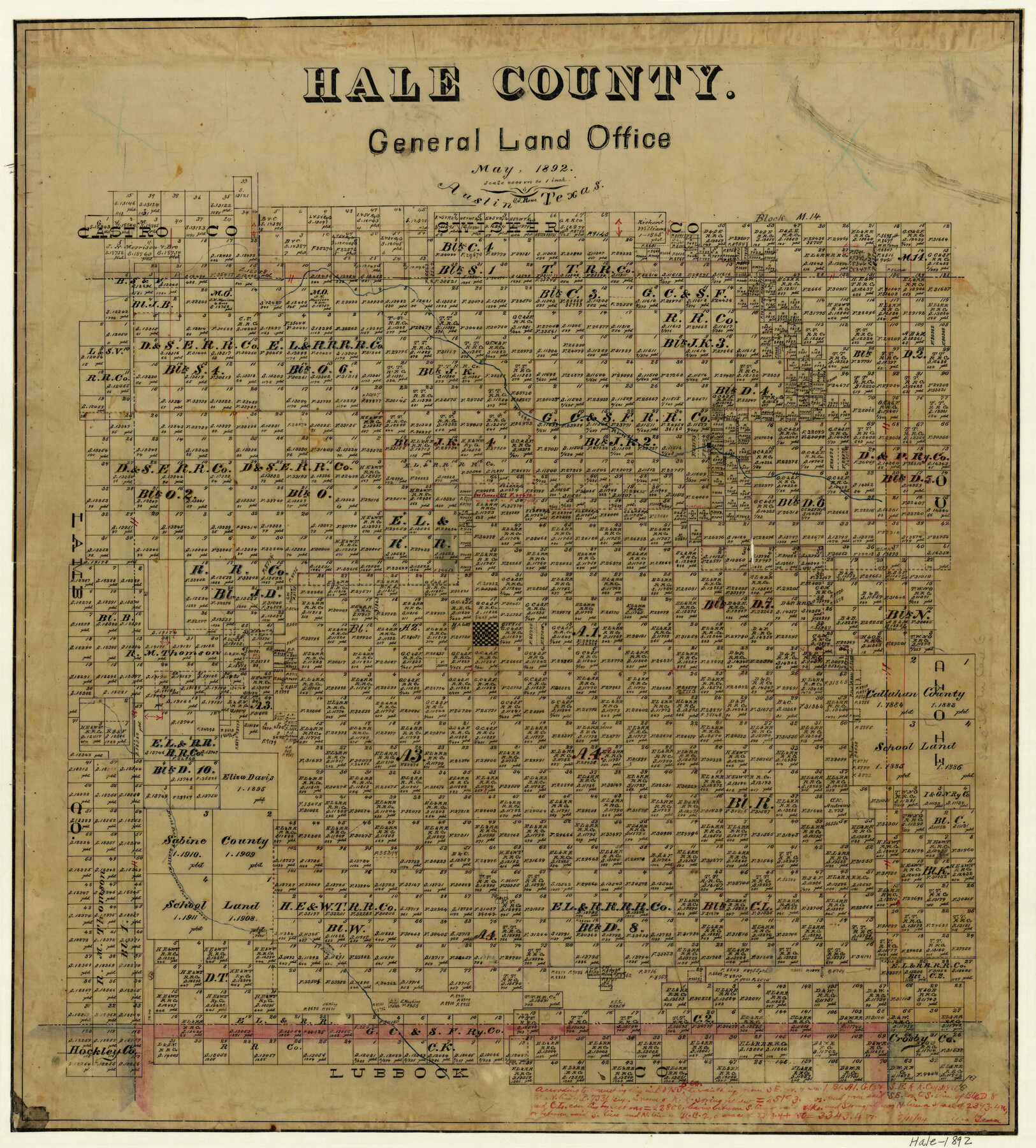
Hale County
-
Map/Doc
3611
-
Collection
General Map Collection
-
Object Dates
5/1892 (Creation Date)
-
People and Organizations
Sidney J. Rowe (Draftsman)
-
Counties
Hale
-
Subjects
County
-
Height x Width
22.5 x 20.4 inches
57.2 x 51.8 cm
-
Features
White River
North Fork of Double Mountain Fork of Brazos River
Hale City
Plainview
Cora Lake
Part of: General Map Collection
Jack County Working Sketch 8

Print $20.00
- Digital $50.00
Jack County Working Sketch 8
1954
Size 30.5 x 35.9 inches
Map/Doc 66434
Chambers County Sketch File 31

Print $40.00
- Digital $50.00
Chambers County Sketch File 31
1856
Size 12.4 x 15.2 inches
Map/Doc 17614
Crockett County Working Sketch 77

Print $40.00
- Digital $50.00
Crockett County Working Sketch 77
1966
Size 29.6 x 58.5 inches
Map/Doc 68410
Hansford County Sketch File 5

Print $20.00
- Digital $50.00
Hansford County Sketch File 5
1926
Size 19.0 x 23.0 inches
Map/Doc 11621
Atascosa County

Print $20.00
- Digital $50.00
Atascosa County
1873
Size 22.2 x 23.1 inches
Map/Doc 3249
Rio Grande Rectification Project, El Paso and Juarez Valley

Print $20.00
- Digital $50.00
Rio Grande Rectification Project, El Paso and Juarez Valley
1935
Size 10.7 x 29.6 inches
Map/Doc 60865
Roberts County Boundary File 2e

Print $20.00
- Digital $50.00
Roberts County Boundary File 2e
Size 28.3 x 8.8 inches
Map/Doc 58367
South Sulphur River, Klondike Sheet

Print $6.00
- Digital $50.00
South Sulphur River, Klondike Sheet
1925
Size 32.2 x 35.5 inches
Map/Doc 65170
Rusk County Working Sketch 10

Print $20.00
- Digital $50.00
Rusk County Working Sketch 10
1980
Size 22.4 x 20.6 inches
Map/Doc 63645
Crockett County Sketch File 8 (1)

Print $6.00
- Digital $50.00
Crockett County Sketch File 8 (1)
1858
Size 9.8 x 4.6 inches
Map/Doc 19652
Runnels County Sketch File 26

Print $20.00
Runnels County Sketch File 26
1949
Size 20.0 x 18.8 inches
Map/Doc 12260
Hockley County Sketch File 6

Print $20.00
- Digital $50.00
Hockley County Sketch File 6
Size 24.9 x 33.0 inches
Map/Doc 11769
You may also like
Flight Mission No. DAG-24K, Frame 48, Matagorda County

Print $20.00
- Digital $50.00
Flight Mission No. DAG-24K, Frame 48, Matagorda County
1953
Size 18.5 x 22.1 inches
Map/Doc 86535
Map of the Houston and Great Northern R.R. from Trinity River to Palestine

Print $40.00
- Digital $50.00
Map of the Houston and Great Northern R.R. from Trinity River to Palestine
1872
Size 30.3 x 119.9 inches
Map/Doc 64549
Map of Young County

Print $20.00
- Digital $50.00
Map of Young County
1897
Size 44.1 x 37.9 inches
Map/Doc 63140
San Augustine Co.

Print $20.00
- Digital $50.00
San Augustine Co.
1949
Size 45.7 x 28.6 inches
Map/Doc 77414
Tom Green County Boundary File 1

Print $48.00
- Digital $50.00
Tom Green County Boundary File 1
Size 8.8 x 3.8 inches
Map/Doc 59329
Hudspeth County Working Sketch 32a

Print $40.00
- Digital $50.00
Hudspeth County Working Sketch 32a
1975
Size 57.4 x 39.3 inches
Map/Doc 66317
Ward County Rolled Sketch 24E

Print $40.00
- Digital $50.00
Ward County Rolled Sketch 24E
1967
Size 42.3 x 64.9 inches
Map/Doc 10116
Val Verde County Rolled Sketch 71

Print $20.00
- Digital $50.00
Val Verde County Rolled Sketch 71
1958
Size 19.5 x 19.5 inches
Map/Doc 8133
Controlled Mosaic by Jack Amman Photogrammetric Engineers, Inc - Sheet 54

Print $20.00
- Digital $50.00
Controlled Mosaic by Jack Amman Photogrammetric Engineers, Inc - Sheet 54
1954
Size 20.0 x 24.0 inches
Map/Doc 83513
[Sketch showing PSL Block AX and C. C. S. D. & R. G. N. G. RR. Co. Block G]
![90838, [Sketch showing PSL Block AX and C. C. S. D. & R. G. N. G. RR. Co. Block G], Twichell Survey Records](https://historictexasmaps.com/wmedia_w700/maps/90838-2.tif.jpg)
Print $20.00
- Digital $50.00
[Sketch showing PSL Block AX and C. C. S. D. & R. G. N. G. RR. Co. Block G]
Size 25.8 x 16.6 inches
Map/Doc 90838
Flight Mission No. BRE-1P, Frame 98, Nueces County

Print $20.00
- Digital $50.00
Flight Mission No. BRE-1P, Frame 98, Nueces County
1956
Size 18.4 x 22.1 inches
Map/Doc 86669
Presidio County Sketch File 62

Print $10.00
- Digital $50.00
Presidio County Sketch File 62
1938
Size 11.2 x 8.8 inches
Map/Doc 34647