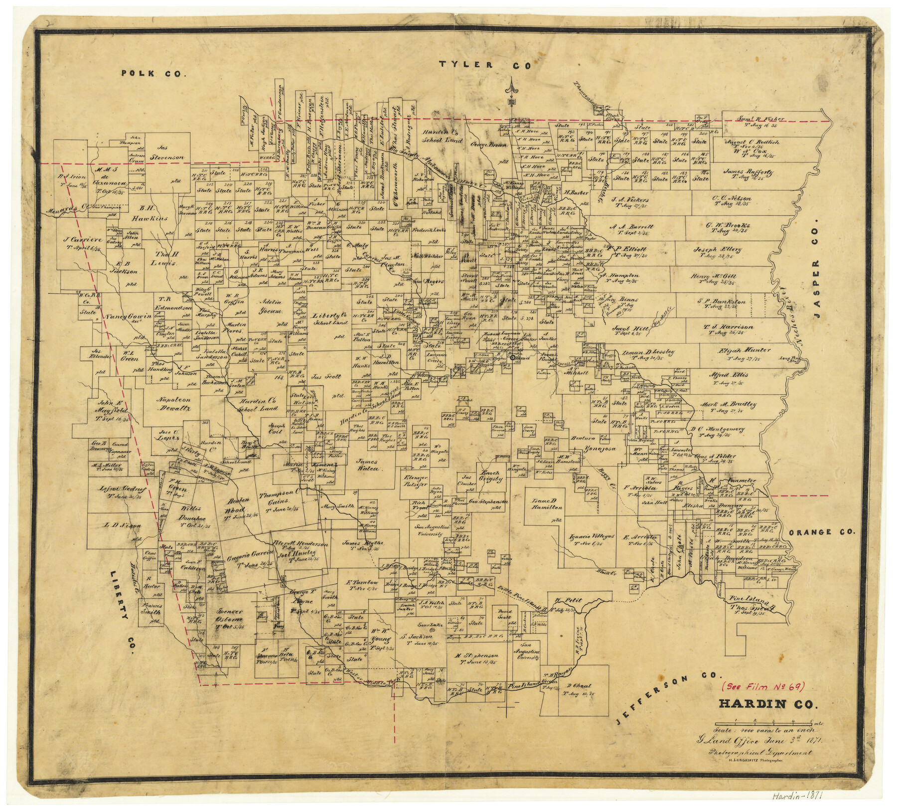
Hardin County
-
Map/Doc
3626
-
Collection
General Map Collection
-
Object Dates
6/3/1871 (Creation Date)
-
People and Organizations
Texas General Land Office (Publisher)
Herman Lungkwitz (Draftsman)
-
Counties
Hardin
-
Subjects
County
-
Height x Width
19.7 x 21.6 inches
50.0 x 54.9 cm
-
Features
Hardin
Middle Fork of Pine Island Bayou
West Fork of Pine Island Bayou
Sour Lake
Little Pine Island Bayou
Pine Island Bayou
Boggy Creek
Batistes Creek
Black Creek
Flat Cypress Creek
Little Cypress Creek
Menards Creek
Big Mill Creek
Long Pine Bluff
Neches River
Beech Creek
Thouvenins Creek
Village Creek
Alabama Creek
Big Sandy Creek
Cypress Creek
Part of: General Map Collection
Presidio County Working Sketch 111

Print $20.00
- Digital $50.00
Presidio County Working Sketch 111
1981
Size 17.1 x 20.4 inches
Map/Doc 71788
Little River, Cameron Sheet

Print $4.00
- Digital $50.00
Little River, Cameron Sheet
1914
Size 28.3 x 24.4 inches
Map/Doc 65062
Flight Mission No. CRC-5R, Frame 20, Chambers County

Print $20.00
- Digital $50.00
Flight Mission No. CRC-5R, Frame 20, Chambers County
1956
Size 18.8 x 22.4 inches
Map/Doc 84942
Chambers County Sketch File 7

Print $4.00
- Digital $50.00
Chambers County Sketch File 7
1867
Size 10.2 x 8.4 inches
Map/Doc 17542
[F. W. & D. C. Ry. Co. Alignment and Right of Way Map, Clay County]
![64745, [F. W. & D. C. Ry. Co. Alignment and Right of Way Map, Clay County], General Map Collection](https://historictexasmaps.com/wmedia_w700/maps/64745-GC.tif.jpg)
Print $20.00
- Digital $50.00
[F. W. & D. C. Ry. Co. Alignment and Right of Way Map, Clay County]
1927
Size 18.7 x 11.8 inches
Map/Doc 64745
Brazoria County Rolled Sketch 47

Print $20.00
- Digital $50.00
Brazoria County Rolled Sketch 47
1951
Size 17.4 x 22.6 inches
Map/Doc 5180
Map of San Antonio Bay and Vicinity in Aransas and Calhoun Counties showing subdivision for mineral development

Print $40.00
- Digital $50.00
Map of San Antonio Bay and Vicinity in Aransas and Calhoun Counties showing subdivision for mineral development
1939
Size 40.4 x 62.8 inches
Map/Doc 2925
Ector County Working Sketch 7

Print $40.00
- Digital $50.00
Ector County Working Sketch 7
1941
Size 48.5 x 29.3 inches
Map/Doc 68850
Map of Cherokee County

Print $40.00
- Digital $50.00
Map of Cherokee County
1933
Size 55.0 x 38.7 inches
Map/Doc 95453
Jasper County Sketch File 30

Print $20.00
- Digital $50.00
Jasper County Sketch File 30
1948
Size 11.3 x 8.8 inches
Map/Doc 27858
Township No. 5 South Range No. 13 West of the Indian Meridian

Print $4.00
- Digital $50.00
Township No. 5 South Range No. 13 West of the Indian Meridian
1875
Size 17.9 x 23.5 inches
Map/Doc 75153
Edwards County Sketch File 12c

Print $20.00
- Digital $50.00
Edwards County Sketch File 12c
Size 23.0 x 26.8 inches
Map/Doc 11425
You may also like
Dickens County Sketch File J

Print $12.00
- Digital $50.00
Dickens County Sketch File J
1904
Size 11.6 x 9.1 inches
Map/Doc 20883
Controlled Mosaic by Jack Amman Photogrammetric Engineers, Inc - Sheet 53

Print $20.00
- Digital $50.00
Controlled Mosaic by Jack Amman Photogrammetric Engineers, Inc - Sheet 53
1954
Size 20.0 x 24.0 inches
Map/Doc 83512
Upshur County Boundary File 1

Print $30.00
- Digital $50.00
Upshur County Boundary File 1
Size 9.4 x 8.6 inches
Map/Doc 59500
Gillespie County Working Sketch 11

Print $20.00
- Digital $50.00
Gillespie County Working Sketch 11
2007
Size 27.8 x 38.0 inches
Map/Doc 87212
Ector County Working Sketch 6

Print $20.00
- Digital $50.00
Ector County Working Sketch 6
1941
Size 47.5 x 22.5 inches
Map/Doc 68849
Hamilton County Rolled Sketch 11

Print $20.00
- Digital $50.00
Hamilton County Rolled Sketch 11
Size 20.1 x 14.1 inches
Map/Doc 6060
J. B. McCauley Irrigated Farm SW Quarter Section 20, Block E

Print $20.00
- Digital $50.00
J. B. McCauley Irrigated Farm SW Quarter Section 20, Block E
1944
Size 20.7 x 23.5 inches
Map/Doc 92335
Map of Uvalde County

Print $20.00
- Digital $50.00
Map of Uvalde County
1862
Size 27.4 x 20.7 inches
Map/Doc 4109
Foard County Working Sketch 2

Print $20.00
- Digital $50.00
Foard County Working Sketch 2
1911
Size 26.3 x 41.4 inches
Map/Doc 69192
Scurry County Rolled Sketch 14

Print $20.00
- Digital $50.00
Scurry County Rolled Sketch 14
2016
Size 23.4 x 41.4 inches
Map/Doc 95404
Flight Mission No. CRK-5P, Frame 157, Refugio County

Print $20.00
- Digital $50.00
Flight Mission No. CRK-5P, Frame 157, Refugio County
1956
Size 18.8 x 22.6 inches
Map/Doc 86938
Stonewall County Rolled Sketch 34

Print $20.00
- Digital $50.00
Stonewall County Rolled Sketch 34
Size 37.5 x 30.2 inches
Map/Doc 7878