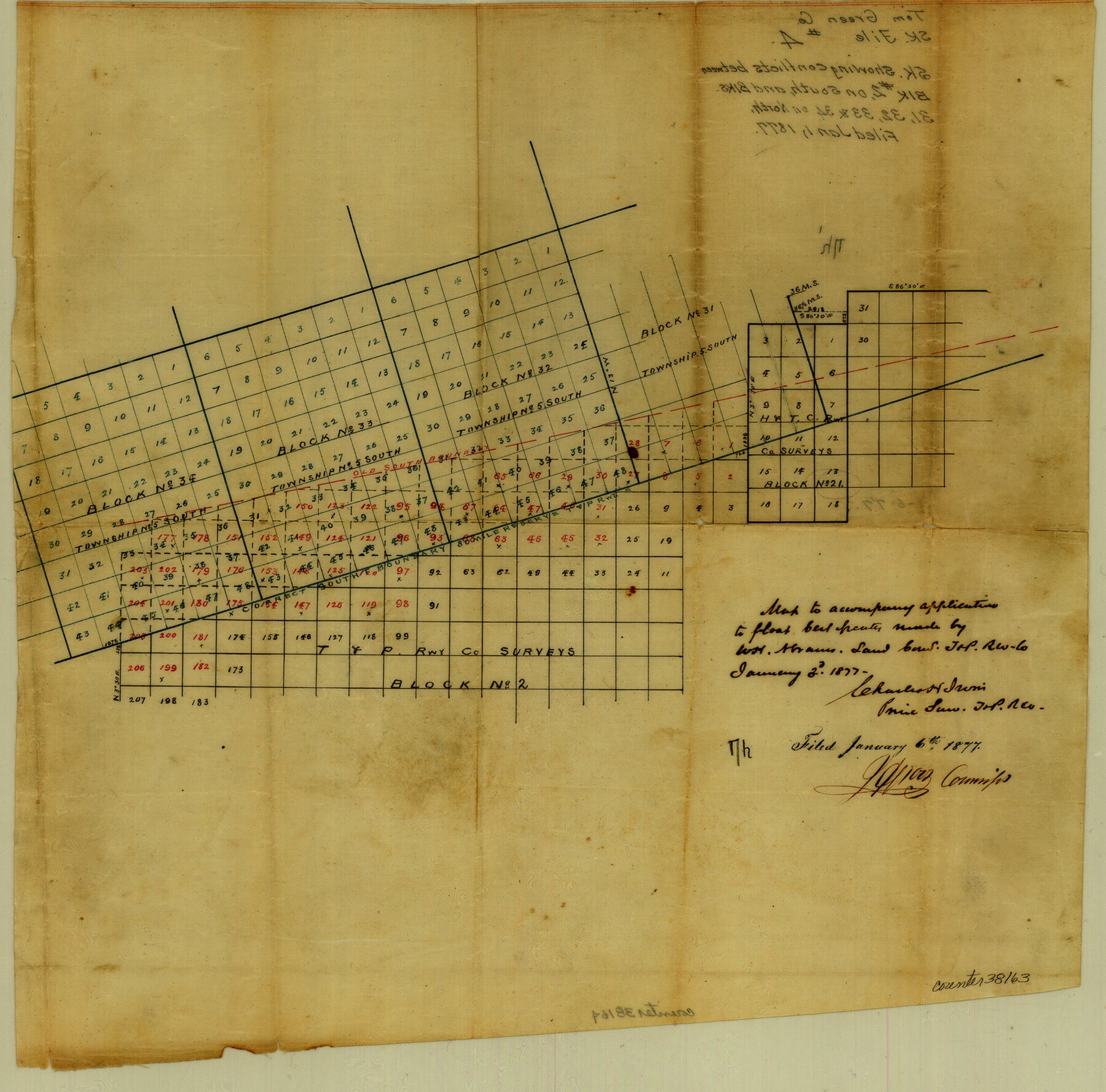
Glasscock County Sketch File 28
[Sketch showing conflict between T. & P. Blocks 31, 32, 33, and 34 and T. & P. Block 2]
-
Map/Doc
38163
-
Collection
General Map Collection
-
Object Dates
1/2/1877 (Creation Date)
1/6/1877 (File Date)
-
People and Organizations
Charles H. Irwin (Surveyor/Engineer)
-
Counties
Glasscock Sterling Reagan
-
Subjects
Surveying Sketch File
-
Height x Width
15.7 x 15.9 inches
39.9 x 40.4 cm
-
Medium
paper, manuscript
Part of: General Map Collection
Burnet County Sketch File 13

Print $4.00
- Digital $50.00
Burnet County Sketch File 13
1848
Size 12.8 x 8.2 inches
Map/Doc 16696
Flight Mission No. CRC-5R, Frame 44, Chambers County

Print $20.00
- Digital $50.00
Flight Mission No. CRC-5R, Frame 44, Chambers County
1956
Size 18.6 x 22.4 inches
Map/Doc 84963
Reeves County Working Sketch 29

Print $20.00
- Digital $50.00
Reeves County Working Sketch 29
1969
Size 20.1 x 41.5 inches
Map/Doc 63472
Garza County Sketch File E

Print $20.00
- Digital $50.00
Garza County Sketch File E
Size 16.0 x 15.7 inches
Map/Doc 11552
Harrisburg, Texas

Print $20.00
- Digital $50.00
Harrisburg, Texas
1854
Size 39.4 x 25.7 inches
Map/Doc 3044
Amistad International Reservoir on Rio Grande 110

Print $20.00
- Digital $50.00
Amistad International Reservoir on Rio Grande 110
1950
Size 41.4 x 29.5 inches
Map/Doc 75541
Galveston County Rolled Sketch 24

Print $20.00
- Digital $50.00
Galveston County Rolled Sketch 24
1973
Size 28.1 x 25.6 inches
Map/Doc 5958
Kinney County Sketch File E

Print $10.00
- Digital $50.00
Kinney County Sketch File E
1885
Size 10.7 x 8.1 inches
Map/Doc 29124

Gregg County Rolled Sketch 23

Print $40.00
- Digital $50.00
Gregg County Rolled Sketch 23
Size 52.9 x 43.3 inches
Map/Doc 9074
Franklin County Sketch File 5

Print $2.00
- Digital $50.00
Franklin County Sketch File 5
Size 8.2 x 10.7 inches
Map/Doc 23017
Reagan County Sketch File 29

Print $20.00
- Digital $50.00
Reagan County Sketch File 29
1951
Size 21.3 x 30.5 inches
Map/Doc 12225
You may also like
Wood County Rolled Sketch 4

Print $20.00
- Digital $50.00
Wood County Rolled Sketch 4
1943
Size 37.0 x 29.2 inches
Map/Doc 8283
Flight Mission No. CRC-3R, Frame 22, Chambers County

Print $20.00
- Digital $50.00
Flight Mission No. CRC-3R, Frame 22, Chambers County
1956
Size 18.6 x 22.3 inches
Map/Doc 84796
Kinney County Rolled Sketch 20

Print $40.00
- Digital $50.00
Kinney County Rolled Sketch 20
1979
Size 37.8 x 59.7 inches
Map/Doc 9357
Flight Mission No. DQN-2K, Frame 3, Calhoun County

Print $20.00
- Digital $50.00
Flight Mission No. DQN-2K, Frame 3, Calhoun County
1953
Size 18.8 x 22.4 inches
Map/Doc 84220
Travis County State Real Property Sketch 5

Print $20.00
- Digital $50.00
Travis County State Real Property Sketch 5
1990
Size 25.4 x 37.5 inches
Map/Doc 61696
Amistad International Reservoir on Rio Grande 110
Print $20.00
- Digital $50.00
Amistad International Reservoir on Rio Grande 110
1950
Size 41.4 x 29.5 inches
Map/Doc 75541
St. Louis, Brownsville & Mexico Railway Location Map from Mile 40 to Mile 60

Print $40.00
- Digital $50.00
St. Louis, Brownsville & Mexico Railway Location Map from Mile 40 to Mile 60
1905
Size 20.3 x 136.1 inches
Map/Doc 89282
Right of Way and Track Map for The Missouri, Kansas & Texas Railway of Texas

Print $40.00
- Digital $50.00
Right of Way and Track Map for The Missouri, Kansas & Texas Railway of Texas
1918
Size 25.9 x 56.0 inches
Map/Doc 64527
Flight Mission No. CGI-4N, Frame 183, Cameron County

Print $20.00
- Digital $50.00
Flight Mission No. CGI-4N, Frame 183, Cameron County
1955
Size 18.6 x 22.3 inches
Map/Doc 84686
Map of Great Britain and Ireland engraved to illustrate Mitchell's school and family geography

Print $20.00
- Digital $50.00
Map of Great Britain and Ireland engraved to illustrate Mitchell's school and family geography
1840
Size 11.8 x 9.5 inches
Map/Doc 93503
Yoakum County Rolled Sketch 3(2)

Print $40.00
- Digital $50.00
Yoakum County Rolled Sketch 3(2)
1959
Size 12.3 x 120.8 inches
Map/Doc 76040
Flight Mission No. BRA-8M, Frame 123, Jefferson County

Print $20.00
- Digital $50.00
Flight Mission No. BRA-8M, Frame 123, Jefferson County
1953
Size 18.7 x 22.3 inches
Map/Doc 85619