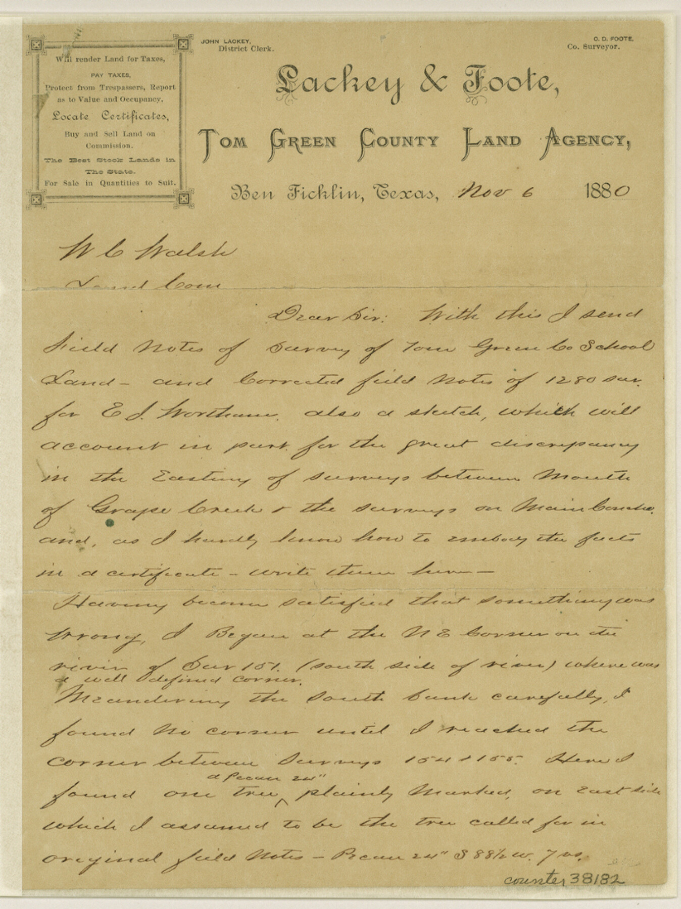
Tom Green County Sketch File 30
[Explanation regarding area in the vicinity of the Tom Green County School Land survey and the E.J. Wortham survey northeast from San Angelo]
-
Map/Doc
38182
-
Collection
General Map Collection
-
Object Dates
11/6/1880 (Creation Date)
11/10/1880 (File Date)
-
People and Organizations
C.D. Foote (Surveyor/Engineer)
-
Counties
Tom Green
-
Subjects
Surveying Sketch File
-
Height x Width
11.0 x 8.2 inches
27.9 x 20.8 cm
-
Medium
paper, manuscript
-
Features
Mouth of Grape Creek
Concho River
Part of: General Map Collection
Travis County Working Sketch 45

Print $20.00
- Digital $50.00
Travis County Working Sketch 45
1975
Size 33.6 x 28.7 inches
Map/Doc 69429
New Counties in the Panhandle

Print $20.00
- Digital $50.00
New Counties in the Panhandle
Size 24.4 x 21.3 inches
Map/Doc 69765
Tom Green County Working Sketch 1

Print $3.00
- Digital $50.00
Tom Green County Working Sketch 1
1915
Size 11.0 x 13.8 inches
Map/Doc 69370
Webb County Boundary File 3a

Print $10.00
- Digital $50.00
Webb County Boundary File 3a
Size 14.2 x 8.7 inches
Map/Doc 59753
Flight Mission No. DAG-23K, Frame 151, Matagorda County

Print $20.00
- Digital $50.00
Flight Mission No. DAG-23K, Frame 151, Matagorda County
1953
Size 15.9 x 15.8 inches
Map/Doc 86499
Matagorda County Sketch File 10

Print $26.00
- Digital $50.00
Matagorda County Sketch File 10
Size 8.3 x 5.2 inches
Map/Doc 30755
Live Oak County Sketch File 11b

Print $6.00
- Digital $50.00
Live Oak County Sketch File 11b
Size 8.2 x 12.6 inches
Map/Doc 30267
St. Louis Southwestern Railway of Texas

Print $20.00
- Digital $50.00
St. Louis Southwestern Railway of Texas
1906
Size 21.4 x 30.0 inches
Map/Doc 64450
Duval County Rolled Sketch 28

Print $20.00
- Digital $50.00
Duval County Rolled Sketch 28
1947
Size 15.9 x 23.7 inches
Map/Doc 5745
Galveston County Sketch File 46

Print $20.00
- Digital $50.00
Galveston County Sketch File 46
1912
Size 14.0 x 34.1 inches
Map/Doc 11541
Flight Mission No. CRC-6R, Frame 10, Chambers County

Print $20.00
- Digital $50.00
Flight Mission No. CRC-6R, Frame 10, Chambers County
1956
Size 18.6 x 22.4 inches
Map/Doc 84964
Harris County Historic Topographic 10

Print $20.00
- Digital $50.00
Harris County Historic Topographic 10
1916
Size 30.2 x 22.9 inches
Map/Doc 65820
You may also like
Aransas County NRC Article 33.136 Sketch 6

Print $23.00
- Digital $50.00
Aransas County NRC Article 33.136 Sketch 6
2005
Size 25.1 x 36.4 inches
Map/Doc 83522
Sketch exhibiting the Corpus Christi and Brazos Santiago bars

Print $20.00
- Digital $50.00
Sketch exhibiting the Corpus Christi and Brazos Santiago bars
1853
Size 23.6 x 15.9 inches
Map/Doc 73008
Pecos County Sketch File U

Print $20.00
- Digital $50.00
Pecos County Sketch File U
1902
Size 20.9 x 32.7 inches
Map/Doc 12188
[Blocks K3-K8 in East half of County]
![90506, [Blocks K3-K8 in East half of County], Twichell Survey Records](https://historictexasmaps.com/wmedia_w700/maps/90506-1.tif.jpg)
Print $2.00
- Digital $50.00
[Blocks K3-K8 in East half of County]
Size 8.8 x 10.5 inches
Map/Doc 90506
Lampasas County Sketch File 4

Print $4.00
- Digital $50.00
Lampasas County Sketch File 4
1861
Size 12.3 x 8.2 inches
Map/Doc 29394
Parker County Working Sketch 21

Print $20.00
- Digital $50.00
Parker County Working Sketch 21
2006
Map/Doc 83655
Harris County Working Sketch 113

Print $20.00
- Digital $50.00
Harris County Working Sketch 113
1982
Size 28.6 x 40.7 inches
Map/Doc 66005
Hood County Sketch File 19

Print $11.00
- Digital $50.00
Hood County Sketch File 19
Size 9.0 x 7.9 inches
Map/Doc 26603
Flight Mission No. CUG-3P, Frame 172, Kleberg County

Print $20.00
- Digital $50.00
Flight Mission No. CUG-3P, Frame 172, Kleberg County
1956
Size 18.6 x 22.2 inches
Map/Doc 86292
Geographical, Statistical, and Historical Map of Mexico

Print $20.00
- Digital $50.00
Geographical, Statistical, and Historical Map of Mexico
1822
Size 18.0 x 22.4 inches
Map/Doc 95694
Val Verde County Sketch File XXX3

Print $6.00
- Digital $50.00
Val Verde County Sketch File XXX3
Size 11.0 x 16.8 inches
Map/Doc 39096
San Patricio County Rolled Sketch 57

Print $40.00
- Digital $50.00
San Patricio County Rolled Sketch 57
2006
Size 37.2 x 50.0 inches
Map/Doc 83554