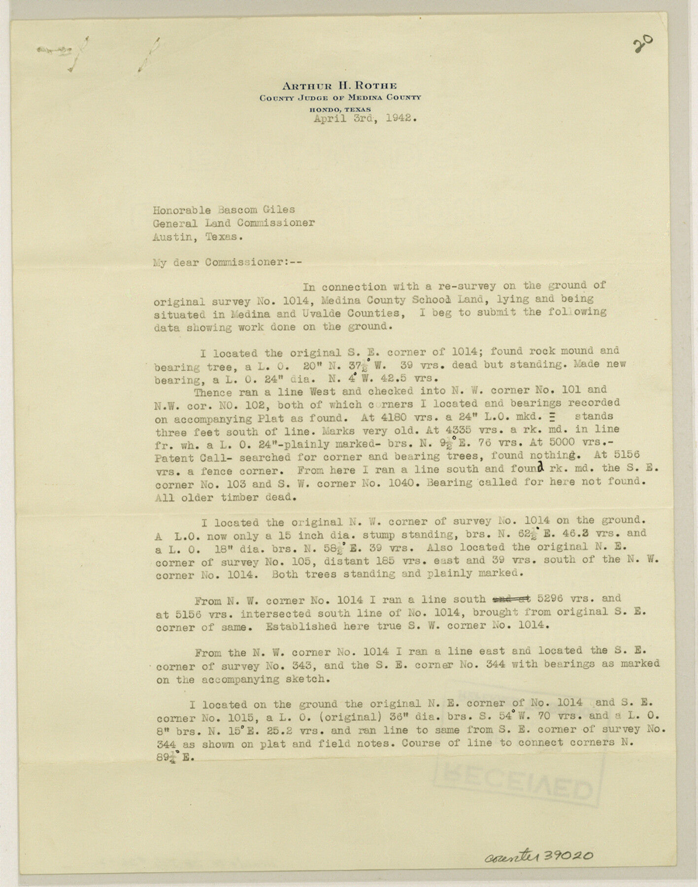
Uvalde County Sketch File 26-2
[Surveyor's statement regarding Medina County School Land league 1014 near the eastern boundary line of the county]
-
Map/Doc
39020
-
Collection
General Map Collection
-
Object Dates
4/3/1942 (Creation Date)
4/15/1942 (File Date)
-
People and Organizations
Arthur H. Rothe (Surveyor/Engineer)
-
Counties
Uvalde Medina
-
Subjects
Surveying Sketch File
-
Height x Width
11.4 x 9.0 inches
29.0 x 22.9 cm
-
Medium
paper, print
-
Comments
See Uvalde County Rolled Sketch 6 (8091) for sketch.
Related maps
Uvalde County Rolled Sketch 6

Print $20.00
- Digital $50.00
Uvalde County Rolled Sketch 6
Size 18.6 x 24.2 inches
Map/Doc 8091
Part of: General Map Collection
Gaines County Rolled Sketch 33

Print $20.00
- Digital $50.00
Gaines County Rolled Sketch 33
1995
Size 17.4 x 18.2 inches
Map/Doc 76413
Travis County Rolled Sketch 32B

Print $20.00
- Digital $50.00
Travis County Rolled Sketch 32B
1948
Size 37.5 x 43.4 inches
Map/Doc 10310
Harris County Working Sketch 39

Print $20.00
- Digital $50.00
Harris County Working Sketch 39
1940
Size 21.6 x 20.1 inches
Map/Doc 65931
Brewster County Rolled Sketch 144

Print $40.00
- Digital $50.00
Brewster County Rolled Sketch 144
Size 51.7 x 48.3 inches
Map/Doc 8526
Nolan County Sketch File 1b

Print $20.00
- Digital $50.00
Nolan County Sketch File 1b
1875
Size 37.6 x 46.7 inches
Map/Doc 10555
Coryell County Working Sketch 31

Print $4.00
- Digital $50.00
Coryell County Working Sketch 31
2008
Size 21.8 x 20.6 inches
Map/Doc 88735
D No. 3 - Sketch of Ocracoke Inlet, North Carolina

Print $20.00
- Digital $50.00
D No. 3 - Sketch of Ocracoke Inlet, North Carolina
1852
Size 17.0 x 16.1 inches
Map/Doc 97210
Milam [District]
![1948, Milam [District], General Map Collection](https://historictexasmaps.com/wmedia_w700/maps/1948.tif.jpg)
Print $40.00
- Digital $50.00
Milam [District]
1850
Size 60.8 x 46.4 inches
Map/Doc 1948

Webb County Rolled Sketch 66

Print $20.00
- Digital $50.00
Webb County Rolled Sketch 66
1957
Size 31.9 x 21.8 inches
Map/Doc 8215
Liberty County Sketch File 43

Print $4.00
- Digital $50.00
Liberty County Sketch File 43
1863
Size 13.6 x 8.5 inches
Map/Doc 30000
Harris County Rolled Sketch 77

Print $20.00
- Digital $50.00
Harris County Rolled Sketch 77
1914
Size 30.0 x 35.6 inches
Map/Doc 6114
You may also like
Wichita County Sketch File 3

Print $8.00
- Digital $50.00
Wichita County Sketch File 3
1856
Size 7.2 x 16.3 inches
Map/Doc 40033
[Capitol lands granted for purpose of building State Capitol]
![2073, [Capitol lands granted for purpose of building State Capitol], General Map Collection](https://historictexasmaps.com/wmedia_w700/maps/2073.tif.jpg)
Print $20.00
- Digital $50.00
[Capitol lands granted for purpose of building State Capitol]
1956
Size 31.5 x 13.0 inches
Map/Doc 2073
Galveston County Sketch File 18

Print $4.00
- Digital $50.00
Galveston County Sketch File 18
Size 5.5 x 8.0 inches
Map/Doc 23388
Washington County Working Sketch 2

Print $20.00
- Digital $50.00
Washington County Working Sketch 2
1981
Size 23.6 x 20.1 inches
Map/Doc 72363
Map of Llano County

Print $20.00
- Digital $50.00
Map of Llano County
1877
Size 19.9 x 25.7 inches
Map/Doc 3824
[G. C. & S. F. Ry. Alinement (sic) and Right of Way Map of Dallas Branch, Johnson County, Texas]
![64651, [G. C. & S. F. Ry. Alinement (sic) and Right of Way Map of Dallas Branch, Johnson County, Texas], General Map Collection](https://historictexasmaps.com/wmedia_w700/maps/64651.tif.jpg)
Print $40.00
- Digital $50.00
[G. C. & S. F. Ry. Alinement (sic) and Right of Way Map of Dallas Branch, Johnson County, Texas]
1926
Size 37.6 x 124.3 inches
Map/Doc 64651
[Military surveys on headwaters of Red River]
![3099, [Military surveys on headwaters of Red River], General Map Collection](https://historictexasmaps.com/wmedia_w700/maps/3099-1.tif.jpg)
Print $20.00
- Digital $50.00
[Military surveys on headwaters of Red River]
1878
Size 31.6 x 39.0 inches
Map/Doc 3099
Current Miscellaneous File 57

Print $4.00
- Digital $50.00
Current Miscellaneous File 57
1955
Size 11.8 x 9.2 inches
Map/Doc 74050
Nacogdoches County Sketch File 20

Print $26.00
- Digital $50.00
Nacogdoches County Sketch File 20
Size 12.6 x 7.9 inches
Map/Doc 32275
Flight Mission No. BRA-16M, Frame 131, Jefferson County

Print $20.00
- Digital $50.00
Flight Mission No. BRA-16M, Frame 131, Jefferson County
1953
Size 18.4 x 22.5 inches
Map/Doc 85741
Liberty County Sketch File 50

Print $42.00
- Digital $50.00
Liberty County Sketch File 50
1879
Size 12.6 x 8.4 inches
Map/Doc 30014
San Augustine County Sketch File 13a

Print $4.00
San Augustine County Sketch File 13a
1879
Size 8.9 x 14.5 inches
Map/Doc 35660