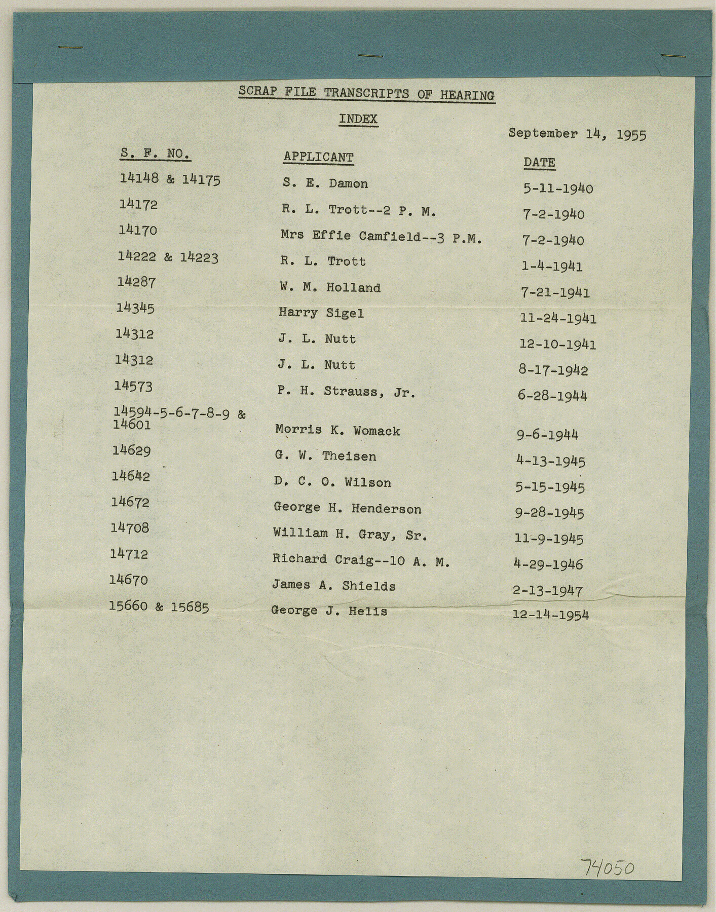
Current Miscellaneous File 57
List of Scrap File transcripts of hearing in transcript box
-
Map/Doc
74050
-
Collection
General Map Collection
-
Object Dates
1955/9/14 (Creation Date)
1955/9/14 (File Date)
-
Subjects
Curiosities
-
Height x Width
11.8 x 9.2 inches
30.0 x 23.4 cm
Part of: General Map Collection
McCulloch County

Print $20.00
- Digital $50.00
McCulloch County
1874
Size 21.9 x 16.8 inches
Map/Doc 3856
Presidio County Working Sketch 45

Print $20.00
- Digital $50.00
Presidio County Working Sketch 45
Size 25.2 x 20.0 inches
Map/Doc 71722
Lampasas County Sketch File 9

Print $4.00
- Digital $50.00
Lampasas County Sketch File 9
1873
Size 9.4 x 7.3 inches
Map/Doc 29408
Angelina County Sketch File 21a

Print $24.00
- Digital $50.00
Angelina County Sketch File 21a
1883
Size 8.3 x 12.6 inches
Map/Doc 13041
Red River County Sketch File 3

Print $4.00
- Digital $50.00
Red River County Sketch File 3
Size 10.4 x 8.3 inches
Map/Doc 35098
Flight Mission No. DIX-5P, Frame 118, Aransas County

Print $20.00
- Digital $50.00
Flight Mission No. DIX-5P, Frame 118, Aransas County
1956
Size 17.7 x 17.8 inches
Map/Doc 83797
Hudspeth County Rolled Sketch 43

Print $40.00
- Digital $50.00
Hudspeth County Rolled Sketch 43
1932
Size 155.2 x 14.6 inches
Map/Doc 9216
Red River County Working Sketch 47

Print $20.00
- Digital $50.00
Red River County Working Sketch 47
1969
Size 34.3 x 24.2 inches
Map/Doc 72030
Amistad International Reservoir on Rio Grande 78a

Print $20.00
- Digital $50.00
Amistad International Reservoir on Rio Grande 78a
1949
Size 28.5 x 40.1 inches
Map/Doc 75507
Map of Liberty County Texas

Print $20.00
- Digital $50.00
Map of Liberty County Texas
1879
Size 24.2 x 23.9 inches
Map/Doc 3814
Brewster County Sketch File N-3a

Print $40.00
- Digital $50.00
Brewster County Sketch File N-3a
Size 14.5 x 18.9 inches
Map/Doc 10962
Flight Mission No. DQN-6K, Frame 90, Calhoun County

Print $20.00
- Digital $50.00
Flight Mission No. DQN-6K, Frame 90, Calhoun County
1953
Size 18.6 x 22.2 inches
Map/Doc 84450
You may also like
Palo Pinto County Rolled Sketch 14A

Print $20.00
- Digital $50.00
Palo Pinto County Rolled Sketch 14A
1993
Size 21.8 x 28.2 inches
Map/Doc 7195
La Salle County Sketch File 19 1/2

Print $28.00
- Digital $50.00
La Salle County Sketch File 19 1/2
1886
Size 14.3 x 8.7 inches
Map/Doc 29515
[Worksheets related to the Wilson Strickland survey and vicinity]
![91282, [Worksheets related to the Wilson Strickland survey and vicinity], Twichell Survey Records](https://historictexasmaps.com/wmedia_w700/maps/91282-1.tif.jpg)
Print $20.00
- Digital $50.00
[Worksheets related to the Wilson Strickland survey and vicinity]
Size 7.9 x 24.3 inches
Map/Doc 91282
Wharton County Sketch File A1

Print $20.00
- Digital $50.00
Wharton County Sketch File A1
1895
Size 15.6 x 36.4 inches
Map/Doc 12669
Atascosa County Working Sketch 31

Print $20.00
- Digital $50.00
Atascosa County Working Sketch 31
1981
Size 21.4 x 16.6 inches
Map/Doc 67227
Photo Index of Texas Coast - Sheet 4 of 6

Print $20.00
- Digital $50.00
Photo Index of Texas Coast - Sheet 4 of 6
1954
Size 20.0 x 24.0 inches
Map/Doc 83442
Map of the Line of the H. & Texas Cen. Railway from the Navasota River, 72 1/2 Miles from Houston, to Corsicana in Navarro Co., 211 mls from Houston

Print $40.00
- Digital $50.00
Map of the Line of the H. & Texas Cen. Railway from the Navasota River, 72 1/2 Miles from Houston, to Corsicana in Navarro Co., 211 mls from Houston
Size 39.2 x 61.4 inches
Map/Doc 64086
[Block B5, Capitol Leagues 217, 218, and 239]
![91438, [Block B5, Capitol Leagues 217, 218, and 239], Twichell Survey Records](https://historictexasmaps.com/wmedia_w700/maps/91438-1.tif.jpg)
Print $3.00
- Digital $50.00
[Block B5, Capitol Leagues 217, 218, and 239]
Size 15.1 x 10.0 inches
Map/Doc 91438
Hardin County Rolled Sketch 8

Print $20.00
- Digital $50.00
Hardin County Rolled Sketch 8
1947
Size 23.7 x 25.8 inches
Map/Doc 6081

Galveston County NRC Article 33.136 Sketch 36

Print $28.00
- Digital $50.00
Galveston County NRC Article 33.136 Sketch 36
2005
Size 24.5 x 36.6 inches
Map/Doc 83409
Webb County Rolled Sketch 29

Print $20.00
- Digital $50.00
Webb County Rolled Sketch 29
1932
Size 16.5 x 15.3 inches
Map/Doc 8187