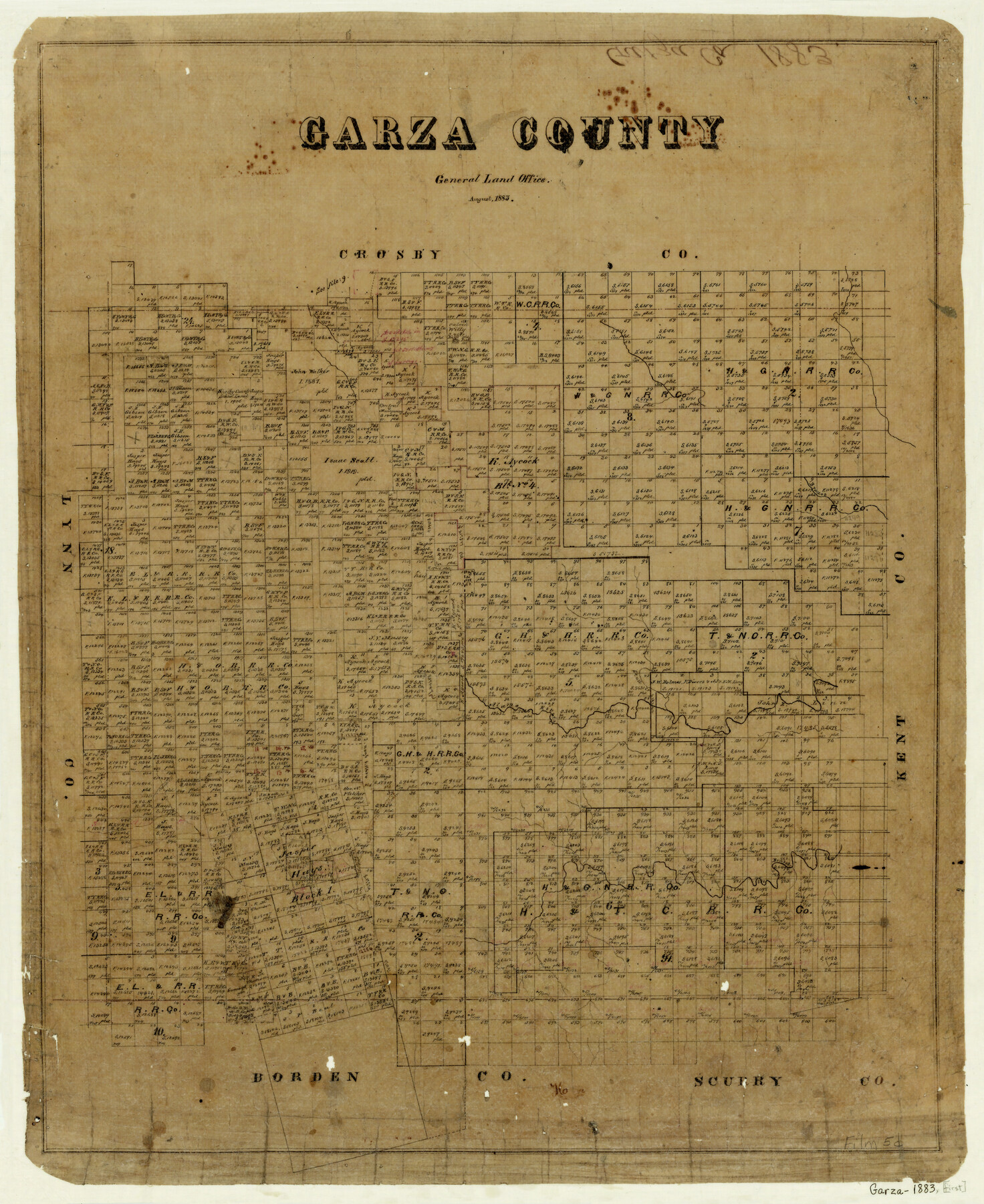
Garza County
-
Map/Doc
4545
-
Collection
General Map Collection
-
Object Dates
8/1883 (Creation Date)
-
Counties
Garza
-
Subjects
County
-
Height x Width
24.9 x 20.3 inches
63.3 x 51.6 cm
-
Features
Duffy's Peak
Brazos River
Alamo River
Skull Creek
Camp Creek
Cottonwood Cañon
Part of: General Map Collection
Collingsworth County Sketch File 4

Print $20.00
- Digital $50.00
Collingsworth County Sketch File 4
1889
Size 23.4 x 31.3 inches
Map/Doc 11131

Nueces County Rolled Sketch 57

Print $48.00
Nueces County Rolled Sketch 57
1979
Size 18.9 x 24.6 inches
Map/Doc 6897
Chambers County Rolled Sketch 22

Print $20.00
- Digital $50.00
Chambers County Rolled Sketch 22
1940
Size 24.9 x 38.9 inches
Map/Doc 5427
Liberty County Working Sketch 11

Print $20.00
- Digital $50.00
Liberty County Working Sketch 11
1913
Size 21.5 x 28.9 inches
Map/Doc 70470
Chambers County Sketch File 35

Print $14.00
- Digital $50.00
Chambers County Sketch File 35
Size 7.1 x 7.6 inches
Map/Doc 17625
Crosby County Sketch File 21

Print $6.00
- Digital $50.00
Crosby County Sketch File 21
Size 13.8 x 8.8 inches
Map/Doc 20087
Williamson County

Print $40.00
- Digital $50.00
Williamson County
1946
Size 37.3 x 54.8 inches
Map/Doc 77460
Knox County Working Sketch 16

Print $20.00
- Digital $50.00
Knox County Working Sketch 16
1963
Size 21.9 x 22.0 inches
Map/Doc 70258
Oldham County Working Sketch 2

Print $20.00
- Digital $50.00
Oldham County Working Sketch 2
1906
Size 16.1 x 15.1 inches
Map/Doc 71324
Glasscock County Working Sketch 12

Print $40.00
- Digital $50.00
Glasscock County Working Sketch 12
1971
Size 51.2 x 39.0 inches
Map/Doc 63185
Galveston County Sketch File 73

Print $78.00
- Digital $50.00
Galveston County Sketch File 73
1998
Size 11.3 x 8.8 inches
Map/Doc 23980
You may also like
Terrell County Working Sketch 50

Print $40.00
- Digital $50.00
Terrell County Working Sketch 50
1958
Size 43.0 x 64.3 inches
Map/Doc 62143
Eastland County

Print $20.00
- Digital $50.00
Eastland County
1945
Size 44.4 x 43.7 inches
Map/Doc 95486
St. Louis Southwestern Railway of Texas

Print $20.00
- Digital $50.00
St. Louis Southwestern Railway of Texas
1906
Size 22.2 x 30.5 inches
Map/Doc 64451
National Map Company's New Road Survey of the United States Showing Main Highways

Digital $50.00
National Map Company's New Road Survey of the United States Showing Main Highways
Size 44.5 x 38.2 inches
Map/Doc 4659
Brazoria County Rolled Sketch 44

Print $20.00
- Digital $50.00
Brazoria County Rolled Sketch 44
1885
Size 23.0 x 27.0 inches
Map/Doc 5178
[Sketch between Wheeler County and Oklahoma]
![89674, [Sketch between Wheeler County and Oklahoma], Twichell Survey Records](https://historictexasmaps.com/wmedia_w700/maps/89674-1.tif.jpg)
Print $40.00
- Digital $50.00
[Sketch between Wheeler County and Oklahoma]
Size 64.9 x 10.2 inches
Map/Doc 89674
[Texas Panhandle North Boundary Line]
![1714, [Texas Panhandle North Boundary Line], General Map Collection](https://historictexasmaps.com/wmedia_w700/maps/1714.tif.jpg)
Print $20.00
- Digital $50.00
[Texas Panhandle North Boundary Line]
1898
Size 43.6 x 11.4 inches
Map/Doc 1714
Jim Hogg County Boundary File 2

Print $4.00
- Digital $50.00
Jim Hogg County Boundary File 2
Size 10.6 x 8.7 inches
Map/Doc 55527
Flight Mission No. BRE-2P, Frame 15, Nueces County

Print $20.00
- Digital $50.00
Flight Mission No. BRE-2P, Frame 15, Nueces County
1956
Size 18.4 x 22.4 inches
Map/Doc 86724
Oldham County Boundary File 1d

Print $68.00
- Digital $50.00
Oldham County Boundary File 1d
Size 14.0 x 8.5 inches
Map/Doc 57759
Harris County Historic Topographic 17

Print $20.00
- Digital $50.00
Harris County Historic Topographic 17
1916
Size 29.5 x 22.7 inches
Map/Doc 65827
Pecos County Working Sketch 85

Print $20.00
- Digital $50.00
Pecos County Working Sketch 85
1962
Size 45.4 x 35.7 inches
Map/Doc 71557