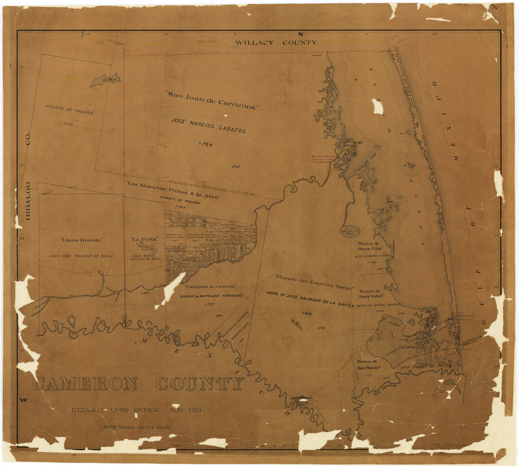
Cameron County
-
Map/Doc
4752
-
Collection
General Map Collection
-
Object Dates
1913 (Creation Date)
-
People and Organizations
Texas General Land Office (Publisher)
Bascom Giles (GLO Commissioner)
H.F. McDonald (Compiler)
H.F. McDonald (Draftsman)
-
Counties
Cameron
-
Subjects
County
-
Height x Width
28.9 x 32.1 inches
73.4 x 81.5 cm
-
Comments
Conservation funded in 2002 with donation from First National Bank of San Benito. See counter 4902 for 1913 tracing and counter 1793 for 1947 retracing.
-
Features
U. S. Light House
Tio Cano
Harlingen
San Benito
La Feria
Lonsboro
Mercedes
Borreda
Point Isabel
Old Light Tower
Clark I[sland]
SLB&M
Brazos Santiago
Boca Chica
Brazos I[sland]
Dyers I[sland]
Olmitos
RGRR
Mezquite
Rio Grande
Brownsville
Fort Brown
Arroyo Colorado
Sal Vieja
El Souz
Gulf of Mexico
Raymondville
Lyford
Green I[sland]
Padre Island
Deer I[sland]
Isla Cortado
Rincon de Buena Vista
Yturia
Sebastian
Loma Verde
Alto Verde
Bayou Atascosa
Rincon de Guajardo
Potrero Largo
Three Islands
Laguna de los Bayous
Donna
Tio Camo Lake
Part of: General Map Collection
Kimble County Working Sketch 96

Print $20.00
- Digital $50.00
Kimble County Working Sketch 96
1921
Size 20.9 x 26.8 inches
Map/Doc 70164
Outer Continental Shelf Leasing Maps (Texas Offshore Operations)

Print $20.00
- Digital $50.00
Outer Continental Shelf Leasing Maps (Texas Offshore Operations)
1954
Size 20.8 x 15.8 inches
Map/Doc 75838
Lampasas County Working Sketch 4

Print $20.00
- Digital $50.00
Lampasas County Working Sketch 4
1941
Size 23.1 x 16.8 inches
Map/Doc 70281
Matagorda Bay and Approaches

Print $20.00
- Digital $50.00
Matagorda Bay and Approaches
1972
Size 34.8 x 44.8 inches
Map/Doc 73384
Lamb County Working Sketch 4

Print $40.00
- Digital $50.00
Lamb County Working Sketch 4
1984
Size 42.9 x 58.0 inches
Map/Doc 70277
Flight Mission No. DIX-6P, Frame 187, Aransas County

Print $20.00
- Digital $50.00
Flight Mission No. DIX-6P, Frame 187, Aransas County
1956
Size 19.1 x 22.7 inches
Map/Doc 83849
Terrell County Rolled Sketch 44

Print $20.00
- Digital $50.00
Terrell County Rolled Sketch 44
1952
Size 18.3 x 22.9 inches
Map/Doc 7947
Culberson County Working Sketch 77

Print $20.00
- Digital $50.00
Culberson County Working Sketch 77
1975
Size 36.7 x 43.3 inches
Map/Doc 68531
Polk County Rolled Sketch 23

Print $20.00
- Digital $50.00
Polk County Rolled Sketch 23
Size 29.1 x 23.5 inches
Map/Doc 7313
Jefferson County Sketch File 13

Print $6.00
- Digital $50.00
Jefferson County Sketch File 13
Size 14.9 x 9.3 inches
Map/Doc 28147
Galveston County Aerial Photograph Index Sheet 3

Print $20.00
- Digital $50.00
Galveston County Aerial Photograph Index Sheet 3
1953
Size 22.2 x 19.2 inches
Map/Doc 83694
Map of Henderson County

Print $20.00
- Digital $50.00
Map of Henderson County
1871
Size 16.3 x 30.3 inches
Map/Doc 4563
You may also like
Falls County Rolled Sketch 1

Print $73.00
- Digital $50.00
Falls County Rolled Sketch 1
1934
Size 10.6 x 15.1 inches
Map/Doc 44540
[Map of the Fort Worth & Denver City Railway, Hartley County, Texas]
![64389, [Map of the Fort Worth & Denver City Railway, Hartley County, Texas], General Map Collection](https://historictexasmaps.com/wmedia_w700/maps/64389.tif.jpg)
Print $40.00
- Digital $50.00
[Map of the Fort Worth & Denver City Railway, Hartley County, Texas]
1887
Size 22.0 x 120.7 inches
Map/Doc 64389
Montgomery County Working Sketch 44

Print $20.00
- Digital $50.00
Montgomery County Working Sketch 44
1956
Size 31.7 x 23.2 inches
Map/Doc 71151
[Surveys in the Bexar District along the Nueces River]
![84, [Surveys in the Bexar District along the Nueces River], General Map Collection](https://historictexasmaps.com/wmedia_w700/maps/84.tif.jpg)
Print $3.00
- Digital $50.00
[Surveys in the Bexar District along the Nueces River]
1847
Size 17.1 x 8.1 inches
Map/Doc 84
Kinney County Working Sketch 16

Print $20.00
- Digital $50.00
Kinney County Working Sketch 16
1946
Size 46.3 x 37.7 inches
Map/Doc 70198
Newton County Sketch File 20a

Print $8.00
- Digital $50.00
Newton County Sketch File 20a
Size 3.7 x 8.8 inches
Map/Doc 32397
Map of Hemphill County

Print $20.00
- Digital $50.00
Map of Hemphill County
1899
Size 41.2 x 38.5 inches
Map/Doc 95527
Atascosa County Working Sketch 33

Print $20.00
- Digital $50.00
Atascosa County Working Sketch 33
1982
Size 16.7 x 13.6 inches
Map/Doc 67229
Ward County Rolled Sketch 23

Print $20.00
- Digital $50.00
Ward County Rolled Sketch 23
1955
Size 31.5 x 37.5 inches
Map/Doc 10111
Kaufman County Sketch File 17

Print $4.00
- Digital $50.00
Kaufman County Sketch File 17
1873
Size 8.0 x 6.1 inches
Map/Doc 28657
Montgomery County Rolled Sketch 42

Print $20.00
- Digital $50.00
Montgomery County Rolled Sketch 42
1939
Size 14.1 x 20.1 inches
Map/Doc 6818
McMullen County Sketch File 2

Print $22.00
- Digital $50.00
McMullen County Sketch File 2
1849
Size 8.3 x 12.4 inches
Map/Doc 31337