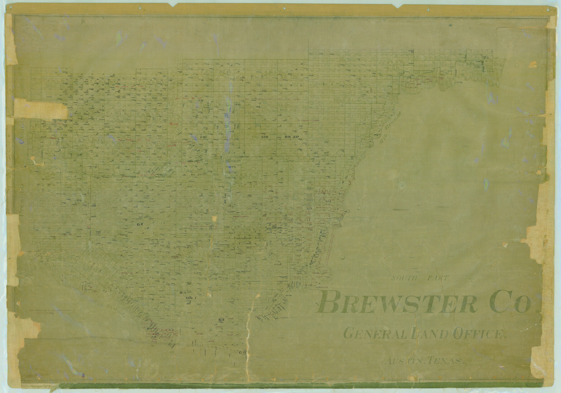
Brewster Co.
-
Map/Doc
4759
-
Collection
General Map Collection
-
Object Dates
1915/1/9 (Creation Date)
-
People and Organizations
Texas General Land Office (Publisher)
H.F. McDonald (Compiler)
H.F. McDonald (Draftsman)
-
Counties
Brewster
-
Subjects
County
-
Height x Width
34.8 x 49.6 inches
88.4 x 126.0 cm
-
Comments
A copy of counter number 4760.
Help Save Texas History - Adopt Me! -
Features
Rio Grande
Tornillo Creek
Lajitas
Terlingua Creek
Boquillas
Boquillas Cañon
Dead Horse Cañon
Grand Cañon
Santa Helena Cañon
San Vicente
Old San Vicente
Little San Vicente Cañon
Big San Vicente Cañon
Part of: General Map Collection
Roberts County Boundary File 2b

Print $38.00
- Digital $50.00
Roberts County Boundary File 2b
Size 9.0 x 7.0 inches
Map/Doc 58344
Crockett County Rolled Sketch 46C

Print $20.00
- Digital $50.00
Crockett County Rolled Sketch 46C
Size 24.5 x 23.8 inches
Map/Doc 5595
Briscoe County

Print $20.00
- Digital $50.00
Briscoe County
1930
Size 46.2 x 39.2 inches
Map/Doc 1787

Plano del Distrilo de Rio Grande Estado de Coahuila

Print $20.00
- Digital $50.00
Plano del Distrilo de Rio Grande Estado de Coahuila
1906
Size 30.3 x 31.5 inches
Map/Doc 1941
Flight Mission No. CRE-2R, Frame 161, Jackson County

Print $20.00
- Digital $50.00
Flight Mission No. CRE-2R, Frame 161, Jackson County
1956
Size 18.5 x 22.1 inches
Map/Doc 85372
Real County Working Sketch 48

Print $20.00
- Digital $50.00
Real County Working Sketch 48
1956
Size 29.4 x 18.5 inches
Map/Doc 71940
Flight Mission No. BQR-4K, Frame 58, Brazoria County

Print $20.00
- Digital $50.00
Flight Mission No. BQR-4K, Frame 58, Brazoria County
1952
Size 18.7 x 22.4 inches
Map/Doc 83991
Presidio County Sketch File 88 1/2

Print $4.00
- Digital $50.00
Presidio County Sketch File 88 1/2
Size 14.4 x 8.8 inches
Map/Doc 34754
Lloyd's Map of the Southern States showing all the Railroads, their Stations & Distances, also the Counties, Towns, Villages, Harbors, Rivers, and Forts

Print $40.00
- Digital $50.00
Lloyd's Map of the Southern States showing all the Railroads, their Stations & Distances, also the Counties, Towns, Villages, Harbors, Rivers, and Forts
1861
Size 39.3 x 54.4 inches
Map/Doc 96556
Houston Ship Channel, Alexander Island to Carpenter Bayou

Print $20.00
- Digital $50.00
Houston Ship Channel, Alexander Island to Carpenter Bayou
1971
Size 35.1 x 46.7 inches
Map/Doc 69907
Parker County

Print $20.00
- Digital $50.00
Parker County
1942
Size 47.7 x 38.9 inches
Map/Doc 95609
You may also like
Bowie County Working Sketch 28

Print $20.00
- Digital $50.00
Bowie County Working Sketch 28
1988
Size 35.1 x 41.5 inches
Map/Doc 67432
Map of Wood County

Print $20.00
- Digital $50.00
Map of Wood County
1857
Size 22.5 x 29.1 inches
Map/Doc 4165
[D. Boone, Block A27]
![92640, [D. Boone, Block A27], Twichell Survey Records](https://historictexasmaps.com/wmedia_w700/maps/92640-1.tif.jpg)
Print $20.00
- Digital $50.00
[D. Boone, Block A27]
Size 37.0 x 24.0 inches
Map/Doc 92640
Map Showing Position of Surveys Represented Hereon

Print $40.00
- Digital $50.00
Map Showing Position of Surveys Represented Hereon
Size 38.9 x 57.2 inches
Map/Doc 75809
Val Verde County Sketch File 22

Print $20.00
- Digital $50.00
Val Verde County Sketch File 22
Size 14.3 x 22.3 inches
Map/Doc 12571
Howard County Boundary File 4b

Print $24.00
- Digital $50.00
Howard County Boundary File 4b
Size 11.3 x 8.9 inches
Map/Doc 55168
Map of Neches River, Texas from Sabine Lake to Beaumont, Texas

Print $40.00
- Digital $50.00
Map of Neches River, Texas from Sabine Lake to Beaumont, Texas
1910
Size 32.4 x 104.0 inches
Map/Doc 2465
Flight Mission No. DQN-1K, Frame 154, Calhoun County

Print $20.00
- Digital $50.00
Flight Mission No. DQN-1K, Frame 154, Calhoun County
1953
Size 18.7 x 22.4 inches
Map/Doc 84213
[Southeast part of County near Jas. H. Price Survey]
![91915, [Southeast part of County near Jas. H. Price Survey], Twichell Survey Records](https://historictexasmaps.com/wmedia_w700/maps/91915-1.tif.jpg)
Print $20.00
- Digital $50.00
[Southeast part of County near Jas. H. Price Survey]
Size 19.9 x 20.0 inches
Map/Doc 91915
Map of Liberty County Texas

Print $20.00
- Digital $50.00
Map of Liberty County Texas
1895
Size 29.7 x 29.4 inches
Map/Doc 3811
[Sketch of part of county with G.H. & S.A. Blk. 3 on North, H. & T.C. Blk. 4 on West, T. & P. Blk. 1 on South, T. & S. Blks. 224 & 301 on East]
![89958, [Sketch of part of county with G.H. & S.A. Blk. 3 on North, H. & T.C. Blk. 4 on West, T. & P. Blk. 1 on South, T. & S. Blks. 224 & 301 on East], Twichell Survey Records](https://historictexasmaps.com/wmedia_w700/maps/89958-1.tif.jpg)
Print $40.00
- Digital $50.00
[Sketch of part of county with G.H. & S.A. Blk. 3 on North, H. & T.C. Blk. 4 on West, T. & P. Blk. 1 on South, T. & S. Blks. 224 & 301 on East]
Size 51.9 x 37.9 inches
Map/Doc 89958
Terrell County Rolled Sketch 39

Print $20.00
- Digital $50.00
Terrell County Rolled Sketch 39
1941
Size 18.7 x 42.9 inches
Map/Doc 7943