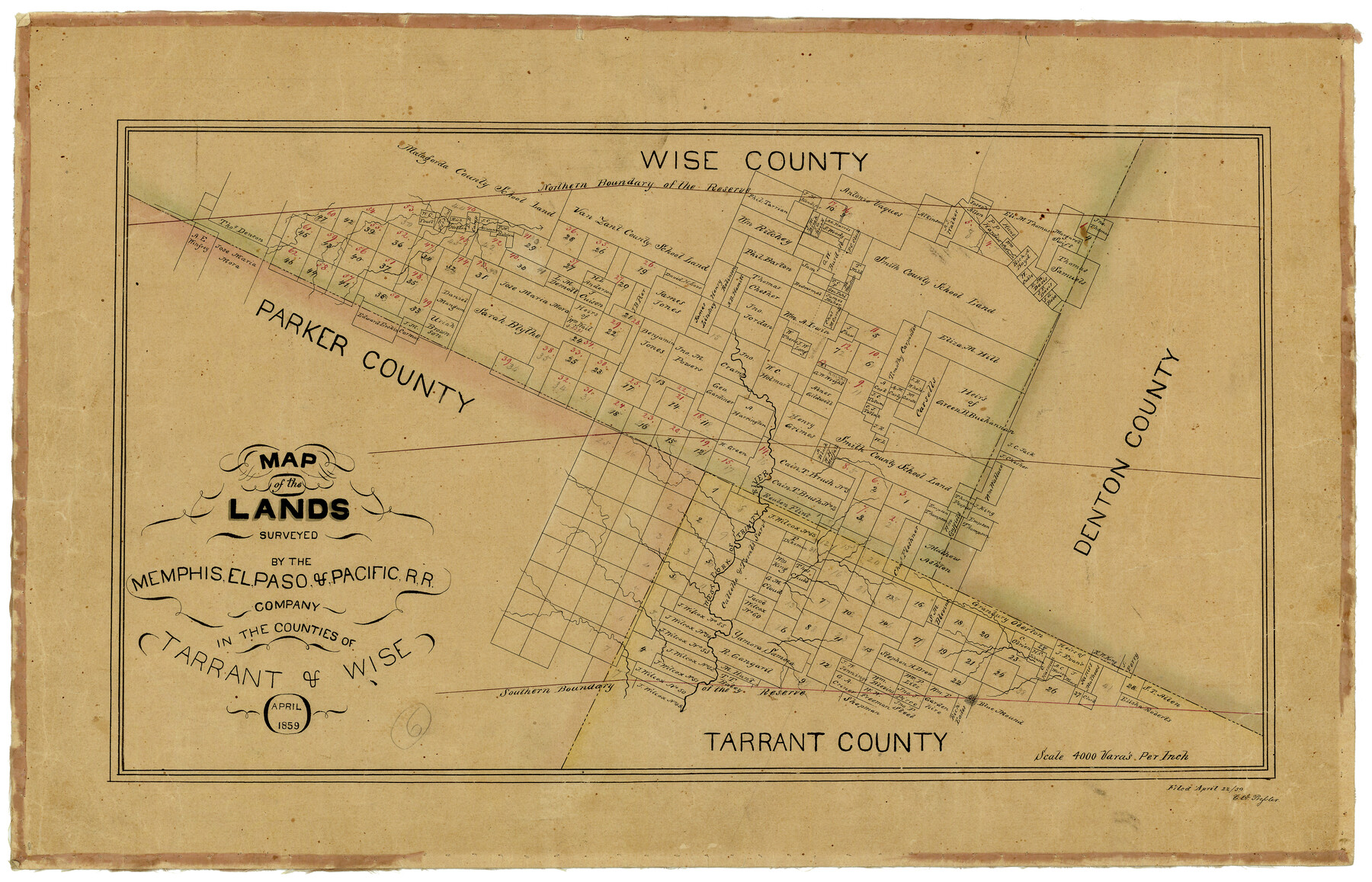
Map of the Lands Surveyed by the Memphis, El Paso & Pacific R.R. Company
T-1-12
-
Map/Doc
4849
-
Collection
General Map Collection
-
Object Dates
4/1859 (Creation Date)
-
Counties
Tarrant Wise
-
Subjects
Railroads
-
Height x Width
13.9 x 21.3 inches
35.3 x 54.1 cm
-
Comments
Became Texas and Pacific Railway Company in 1873.
Adopted with contributions from the State Employee Charitable Campaign (SECC) and conservation funded in 2011.
Part of: General Map Collection
Map of Starr County

Print $20.00
- Digital $50.00
Map of Starr County
1880
Size 46.8 x 27.0 inches
Map/Doc 4044
[Bastrop District]
![16941, [Bastrop District], General Map Collection](https://historictexasmaps.com/wmedia_w700/maps/16941-1.tif.jpg)
Print $40.00
- Digital $50.00
[Bastrop District]
1838
Size 67.3 x 44.2 inches
Map/Doc 16941
Erforschung von Nordwest-Texas

Print $20.00
- Digital $50.00
Erforschung von Nordwest-Texas
1873
Size 11.4 x 9.4 inches
Map/Doc 95144
Maps of Gulf Intracoastal Waterway, Texas - Sabine River to the Rio Grande and connecting waterways including ship channels

Print $20.00
- Digital $50.00
Maps of Gulf Intracoastal Waterway, Texas - Sabine River to the Rio Grande and connecting waterways including ship channels
1966
Size 14.5 x 22.1 inches
Map/Doc 61917
Right of Way & Track Map, St. Louis, Brownsville & Mexico Ry. operated by St. Louis, Brownsville & Mexico Ry. Co.

Print $40.00
- Digital $50.00
Right of Way & Track Map, St. Louis, Brownsville & Mexico Ry. operated by St. Louis, Brownsville & Mexico Ry. Co.
1919
Size 25.5 x 57.1 inches
Map/Doc 64624
Bexar County Working Sketch 12

Print $20.00
- Digital $50.00
Bexar County Working Sketch 12
1954
Size 24.7 x 21.0 inches
Map/Doc 67328
Trinity County Sketch File 23

Print $26.00
- Digital $50.00
Trinity County Sketch File 23
1861
Size 6.9 x 8.3 inches
Map/Doc 38552
Jasper County Boundary File 4a

Print $20.00
- Digital $50.00
Jasper County Boundary File 4a
Size 36.6 x 17.6 inches
Map/Doc 55491
Young County Sketch File 18

Print $10.00
- Digital $50.00
Young County Sketch File 18
1929
Size 11.5 x 8.7 inches
Map/Doc 40882
Flight Mission No. DQO-2K, Frame 92, Galveston County

Print $20.00
- Digital $50.00
Flight Mission No. DQO-2K, Frame 92, Galveston County
1952
Size 18.8 x 22.5 inches
Map/Doc 85019
Flight Mission No. DAG-19K, Frame 58, Matagorda County

Print $20.00
- Digital $50.00
Flight Mission No. DAG-19K, Frame 58, Matagorda County
1952
Size 18.5 x 16.3 inches
Map/Doc 86385
Map of Texas coastal area showing submerged area to which counties along the Gulf of Mexico are entitled

Print $20.00
- Digital $50.00
Map of Texas coastal area showing submerged area to which counties along the Gulf of Mexico are entitled
1939
Size 28.3 x 44.2 inches
Map/Doc 3105
You may also like
Liberty County Working Sketch 42

Print $20.00
- Digital $50.00
Liberty County Working Sketch 42
1953
Size 24.0 x 35.8 inches
Map/Doc 70501
Swisher County Rolled Sketch 6

Print $20.00
- Digital $50.00
Swisher County Rolled Sketch 6
1941
Size 43.0 x 27.6 inches
Map/Doc 7907
Callahan County Sketch File 11

Print $64.00
- Digital $50.00
Callahan County Sketch File 11
Size 11.4 x 8.4 inches
Map/Doc 35887
Garza County Rolled Sketch 13

Print $26.00
- Digital $50.00
Garza County Rolled Sketch 13
1935
Size 45.5 x 36.7 inches
Map/Doc 9047
[Blocks 178, 194, Z]
![91579, [Blocks 178, 194, Z], Twichell Survey Records](https://historictexasmaps.com/wmedia_w700/maps/91579-1.tif.jpg)
Print $3.00
- Digital $50.00
[Blocks 178, 194, Z]
Size 12.8 x 10.5 inches
Map/Doc 91579
Jefferson County Sketch File 48

Print $20.00
- Digital $50.00
Jefferson County Sketch File 48
1875
Size 19.8 x 21.0 inches
Map/Doc 11882
Map showing survey for proposed ship channel from Brownsville to Brazos Santiago Pass

Print $20.00
- Digital $50.00
Map showing survey for proposed ship channel from Brownsville to Brazos Santiago Pass
1912
Size 18.4 x 28.4 inches
Map/Doc 72900
Val Verde County Sketch File 20

Print $20.00
- Digital $50.00
Val Verde County Sketch File 20
1881
Size 26.5 x 37.2 inches
Map/Doc 12569
Harris County Rolled Sketch 31

Print $40.00
- Digital $50.00
Harris County Rolled Sketch 31
1893
Size 63.5 x 40.0 inches
Map/Doc 9111
A Few Things About Rice as grown along the line of the Sunset Route in Louisiana and Texas

A Few Things About Rice as grown along the line of the Sunset Route in Louisiana and Texas
1904
Map/Doc 96724
Map of Eastland Co.

Print $20.00
- Digital $50.00
Map of Eastland Co.
1896
Size 40.8 x 43.8 inches
Map/Doc 66809
