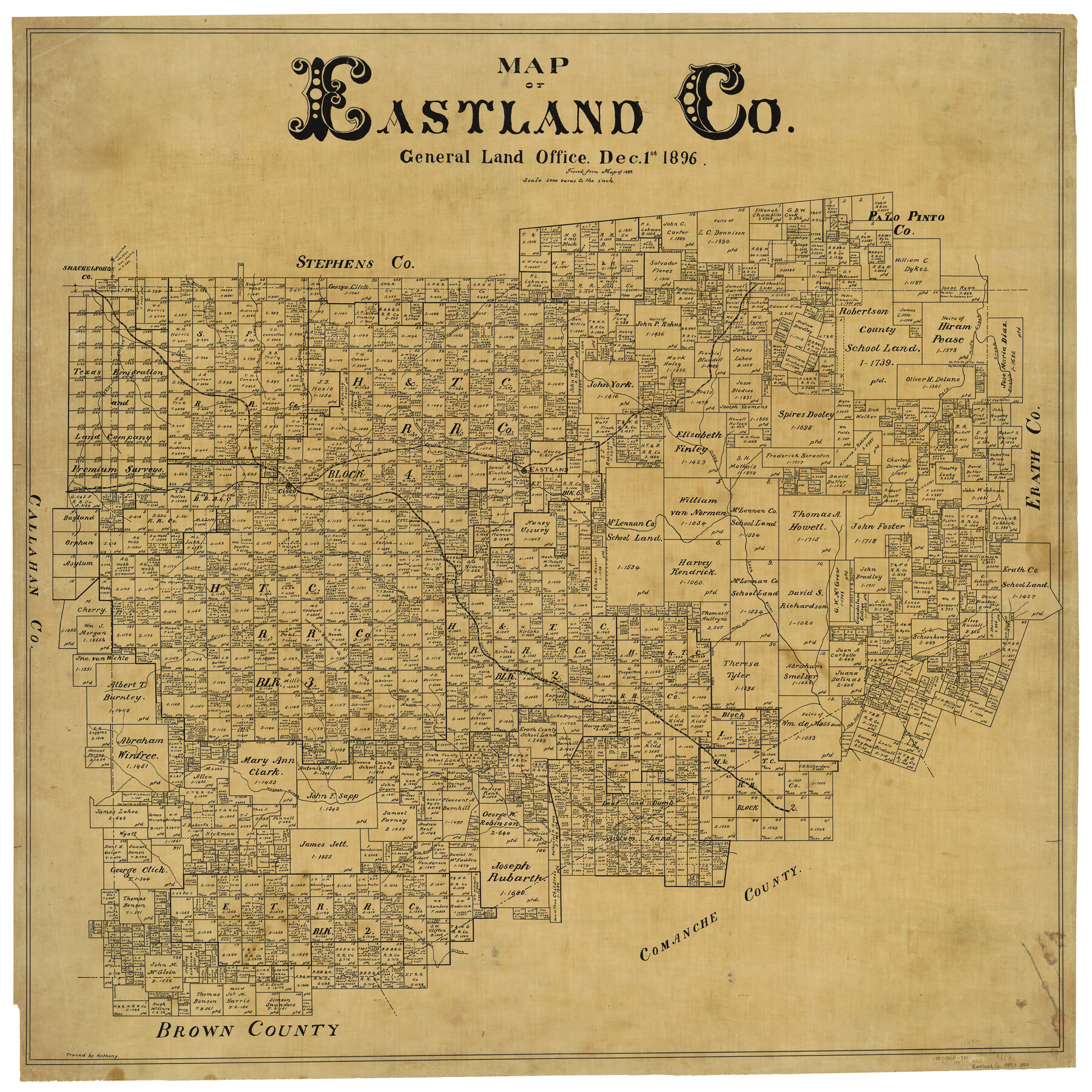
Map of Eastland Co.
-
Map/Doc
4937
-
Collection
General Map Collection
-
Object Dates
1896/12/1 (Creation Date)
-
People and Organizations
Texas General Land Office (Publisher)
-
Counties
Eastland
-
Subjects
County
-
Height x Width
43.1 x 44.2 inches
109.5 x 112.3 cm
-
Comments
Traced from 1889 map by Anthony.
Part of: General Map Collection
Uvalde County Sketch File 11

Print $46.00
- Digital $50.00
Uvalde County Sketch File 11
1886
Size 12.1 x 13.1 inches
Map/Doc 38972
El Paso County Rolled Sketch 50

Print $40.00
- Digital $50.00
El Paso County Rolled Sketch 50
Size 19.7 x 76.0 inches
Map/Doc 76430
Dimmit County Sketch File 14

Print $20.00
- Digital $50.00
Dimmit County Sketch File 14
1884
Size 35.7 x 23.3 inches
Map/Doc 11342
Real County Rolled Sketch 19

Print $20.00
- Digital $50.00
Real County Rolled Sketch 19
Size 42.0 x 41.7 inches
Map/Doc 9839
Hudspeth County Rolled Sketch 65

Print $40.00
- Digital $50.00
Hudspeth County Rolled Sketch 65
1988
Size 70.5 x 37.7 inches
Map/Doc 9229
Eastland County Working Sketch 37

Print $20.00
- Digital $50.00
Eastland County Working Sketch 37
1967
Size 23.7 x 18.1 inches
Map/Doc 68818
Coke County Rolled Sketch 23

Print $20.00
- Digital $50.00
Coke County Rolled Sketch 23
1944
Size 13.7 x 14.7 inches
Map/Doc 5524
Van Zandt County

Print $20.00
- Digital $50.00
Van Zandt County
1870
Size 22.9 x 21.6 inches
Map/Doc 4112
Panola County Working Sketch 22

Print $20.00
- Digital $50.00
Panola County Working Sketch 22
1951
Map/Doc 71431
San Patricio County Rolled Sketch 43

Print $1233.00
- Digital $50.00
San Patricio County Rolled Sketch 43
Size 8.8 x 14.2 inches
Map/Doc 41814
Grant of Miguel Rabago

Print $2.00
- Digital $50.00
Grant of Miguel Rabago
Size 8.6 x 8.4 inches
Map/Doc 76047
Flight Mission No. CRC-2R, Frame 136, Chambers County

Print $20.00
- Digital $50.00
Flight Mission No. CRC-2R, Frame 136, Chambers County
1956
Size 18.7 x 22.4 inches
Map/Doc 84752
You may also like
Liberty County Sketch File 37a

Print $6.00
- Digital $50.00
Liberty County Sketch File 37a
1895
Size 15.1 x 11.5 inches
Map/Doc 29981
Newton County Sketch File 9

Print $4.00
- Digital $50.00
Newton County Sketch File 9
Size 9.8 x 8.3 inches
Map/Doc 32378
Flight Mission No. DAH-9M, Frame 165, Orange County

Print $20.00
- Digital $50.00
Flight Mission No. DAH-9M, Frame 165, Orange County
1953
Size 18.5 x 22.3 inches
Map/Doc 86864
L. Wright's Subdivision of the Southwest Corner of Survey Number 6, D4]
![90785, L. Wright's Subdivision of the Southwest Corner of Survey Number 6, D4], Twichell Survey Records](https://historictexasmaps.com/wmedia_w700/maps/90785-1.tif.jpg)
Print $20.00
- Digital $50.00
L. Wright's Subdivision of the Southwest Corner of Survey Number 6, D4]
1906
Size 14.1 x 18.5 inches
Map/Doc 90785
Map of the State of Texas published by the International and Gt. Northern Railroad

Print $20.00
- Digital $50.00
Map of the State of Texas published by the International and Gt. Northern Railroad
1881
Size 16.0 x 22.2 inches
Map/Doc 94092

Map of Jones County

Print $20.00
- Digital $50.00
Map of Jones County
1898
Size 41.2 x 40.0 inches
Map/Doc 16862
Hall County Sketch File 15

Print $6.00
- Digital $50.00
Hall County Sketch File 15
Size 5.7 x 16.9 inches
Map/Doc 24814
San Luis Pass to East Matagorda Bay

Print $20.00
- Digital $50.00
San Luis Pass to East Matagorda Bay
1966
Size 34.6 x 46.5 inches
Map/Doc 69965
Carson County Boundary File 8a

Print $40.00
- Digital $50.00
Carson County Boundary File 8a
Size 12.5 x 34.7 inches
Map/Doc 51173
Jackson County Sketch File 27

Print $20.00
- Digital $50.00
Jackson County Sketch File 27
1938
Size 25.6 x 24.8 inches
Map/Doc 11847
Nueces County Rolled Sketch 51A

Print $20.00
- Digital $50.00
Nueces County Rolled Sketch 51A
1978
Size 27.6 x 39.1 inches
Map/Doc 6890