Chambers County Rolled Sketch FD2
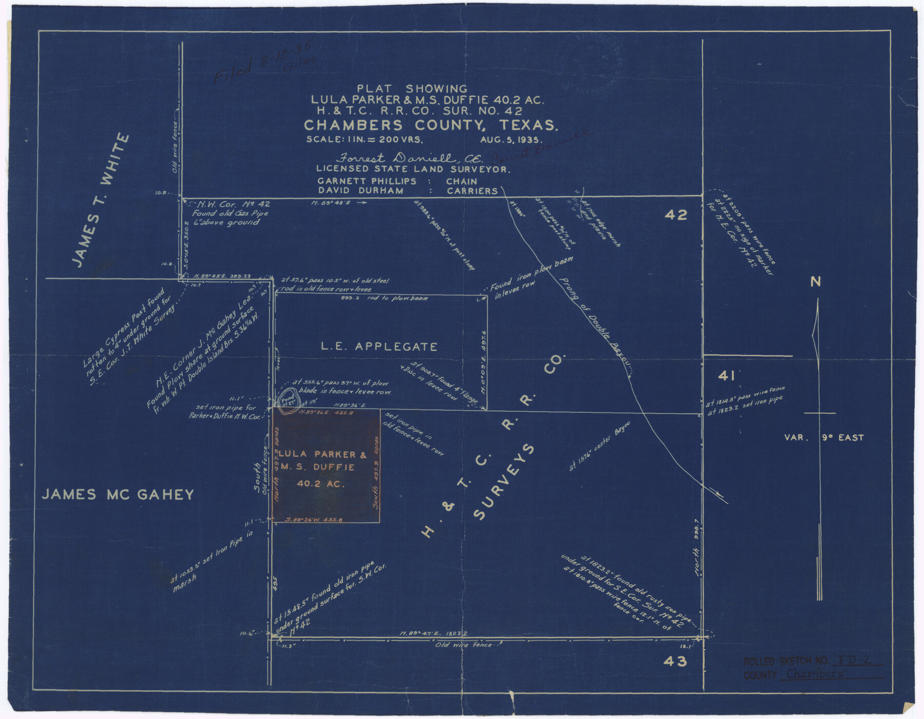
Plat showing Lula Parker & M.S. Duffie 40.2 ac. H. & T. C. R.R. Co. sur. no. 42
-
Map/Doc
5434
-
Collection
General Map Collection
-
Object Dates
1935/8/12 (File Date)
1935/8/5 (Creation Date)
-
People and Organizations
Forrest Daniell (Surveyor/Engineer)
Garnett Phillips (Chainman/Field Personnel)
David Durham (Chainman/Field Personnel)
-
Counties
Chambers
-
Subjects
Surveying Rolled Sketch
-
Height x Width
15.3 x 19.7 inches
38.9 x 50.0 cm
-
Medium
blueprint/diazo
-
Scale
1" = 200 varas
-
Comments
See Chambers County Sketch File 57 (18102) for report.
Related maps
Chambers County Sketch File 57

Print $13.00
- Digital $50.00
Chambers County Sketch File 57
1935
Size 14.7 x 8.9 inches
Map/Doc 18102
Part of: General Map Collection
Nueces County Sketch File 3

Print $40.00
- Digital $50.00
Nueces County Sketch File 3
1847
Size 12.5 x 15.1 inches
Map/Doc 32503
Cottle County Working Sketch 7

Print $20.00
- Digital $50.00
Cottle County Working Sketch 7
1916
Size 28.4 x 30.4 inches
Map/Doc 68317
Webb County Rolled Sketch 24

Print $20.00
- Digital $50.00
Webb County Rolled Sketch 24
1930
Size 33.0 x 23.0 inches
Map/Doc 8184
Oldham County Working Sketch 11

Print $20.00
- Digital $50.00
Oldham County Working Sketch 11
2014
Size 26.6 x 32.7 inches
Map/Doc 93686
Wilson County Boundary File 1

Print $58.00
- Digital $50.00
Wilson County Boundary File 1
Size 9.6 x 4.5 inches
Map/Doc 60058
Yoakum County Rolled Sketch 7

Print $20.00
- Digital $50.00
Yoakum County Rolled Sketch 7
2012
Size 25.9 x 18.7 inches
Map/Doc 93291
Andrews County Sketch File 18

Print $12.00
- Digital $50.00
Andrews County Sketch File 18
Size 11.3 x 8.9 inches
Map/Doc 12907
Cherokee County Sketch File 12b

Print $6.00
- Digital $50.00
Cherokee County Sketch File 12b
1850
Size 7.9 x 7.7 inches
Map/Doc 18142
Flight Mission No. DQN-1K, Frame 33, Calhoun County

Print $20.00
- Digital $50.00
Flight Mission No. DQN-1K, Frame 33, Calhoun County
1953
Size 15.5 x 15.5 inches
Map/Doc 84138
Tom Green County Rolled Sketch 17

Print $40.00
- Digital $50.00
Tom Green County Rolled Sketch 17
Size 49.2 x 37.8 inches
Map/Doc 10005
Leon County Rolled Sketch 27A

Print $40.00
- Digital $50.00
Leon County Rolled Sketch 27A
Size 50.5 x 47.8 inches
Map/Doc 9437
Brazoria County Working Sketch 48

Print $20.00
- Digital $50.00
Brazoria County Working Sketch 48
1990
Size 25.2 x 29.5 inches
Map/Doc 67533
You may also like
Map of the County and City of Galveston, Texas

Print $20.00
Map of the County and City of Galveston, Texas
1891
Size 24.5 x 34.4 inches
Map/Doc 79290
Castro County Sketch File 4h

Print $4.00
- Digital $50.00
Castro County Sketch File 4h
Size 13.6 x 8.6 inches
Map/Doc 17479
Menard County Sketch File 15

Print $8.00
- Digital $50.00
Menard County Sketch File 15
1892
Size 12.9 x 8.3 inches
Map/Doc 31510
Burleson County Working Sketch 30

Print $20.00
- Digital $50.00
Burleson County Working Sketch 30
1981
Size 37.4 x 26.9 inches
Map/Doc 67749
Culberson County Working Sketch 25

Print $40.00
- Digital $50.00
Culberson County Working Sketch 25
1951
Size 30.5 x 52.9 inches
Map/Doc 68478
Crockett County Working Sketch 95

Print $20.00
- Digital $50.00
Crockett County Working Sketch 95
1979
Size 26.6 x 47.2 inches
Map/Doc 68428
Anderson County Sketch File 23

Print $10.00
- Digital $50.00
Anderson County Sketch File 23
1942
Size 11.2 x 8.7 inches
Map/Doc 12794
Flight Mission No. DIX-5P, Frame 103, Aransas County

Print $20.00
- Digital $50.00
Flight Mission No. DIX-5P, Frame 103, Aransas County
1956
Size 17.5 x 18.2 inches
Map/Doc 83781
Real County Working Sketch 38

Print $20.00
- Digital $50.00
Real County Working Sketch 38
1951
Size 34.0 x 37.9 inches
Map/Doc 71930
[Public School Land Blocks B1 and B7]
![91974, [Public School Land Blocks B1 and B7], Twichell Survey Records](https://historictexasmaps.com/wmedia_w700/maps/91974-1.tif.jpg)
Print $20.00
- Digital $50.00
[Public School Land Blocks B1 and B7]
Size 22.9 x 14.8 inches
Map/Doc 91974
Sketch in Cochran County, Texas

Print $20.00
- Digital $50.00
Sketch in Cochran County, Texas
1949
Size 21.8 x 21.0 inches
Map/Doc 92495
Freestone County State of Texas

Print $20.00
- Digital $50.00
Freestone County State of Texas
1888
Size 27.2 x 21.6 inches
Map/Doc 3562