Anderson County Sketch File 23
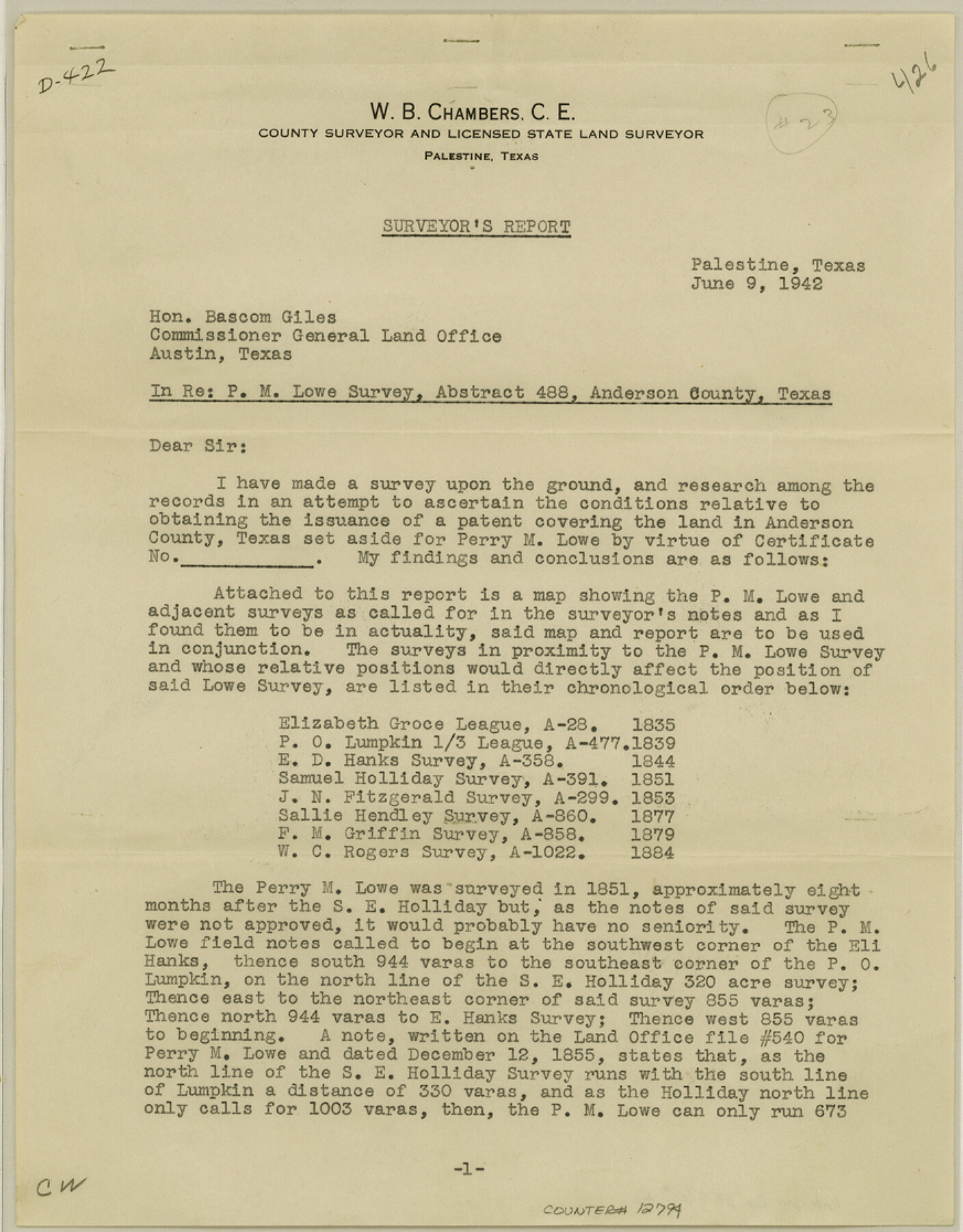
Surveyor's report regarding P.M. Lowe survey, abstract 488, Anderson County, Texas
-
Map/Doc
12794
-
Collection
General Map Collection
-
Object Dates
1942/6/9 (Creation Date)
1942/6/15 (File Date)
-
People and Organizations
W.B. Chambers (Surveyor/Engineer)
-
Counties
Anderson
-
Subjects
Surveying Sketch File
-
Height x Width
11.2 x 8.7 inches
28.4 x 22.1 cm
-
Medium
paper, print
-
Comments
See Anderson County Rolled Sketch 8 (77154) for plat
Related maps
Anderson County Rolled Sketch 8

Print $20.00
- Digital $50.00
Anderson County Rolled Sketch 8
Size 34.8 x 23.9 inches
Map/Doc 77154
Part of: General Map Collection
Pecos County Working Sketch 58

Print $20.00
- Digital $50.00
Pecos County Working Sketch 58
1949
Size 20.5 x 22.0 inches
Map/Doc 71530
Parker County Working Sketch 16

Print $20.00
- Digital $50.00
Parker County Working Sketch 16
1990
Map/Doc 71466
Crosby County Sketch File 14a

Print $40.00
- Digital $50.00
Crosby County Sketch File 14a
Size 18.9 x 20.5 inches
Map/Doc 11249
Aransas County Sketch File 3

Print $4.00
- Digital $50.00
Aransas County Sketch File 3
Size 8.0 x 12.7 inches
Map/Doc 13104
Pecos County Rolled Sketch 82

Print $20.00
- Digital $50.00
Pecos County Rolled Sketch 82
1930
Size 28.3 x 25.8 inches
Map/Doc 10191
Brazoria County Rolled Sketch 40

Print $20.00
- Digital $50.00
Brazoria County Rolled Sketch 40
1954
Size 32.1 x 21.5 inches
Map/Doc 5175
Webb County Sketch File 59

Print $8.00
- Digital $50.00
Webb County Sketch File 59
1943
Size 14.4 x 9.0 inches
Map/Doc 39851
Chambers County Aerial Photograph Index Sheet 2

Print $20.00
- Digital $50.00
Chambers County Aerial Photograph Index Sheet 2
1956
Size 19.4 x 15.7 inches
Map/Doc 83683
Flight Mission No. CRK-3P, Frame 65, Refugio County

Print $20.00
- Digital $50.00
Flight Mission No. CRK-3P, Frame 65, Refugio County
1956
Size 18.5 x 22.4 inches
Map/Doc 86907
Gregg County Working Sketch 22

Print $20.00
- Digital $50.00
Gregg County Working Sketch 22
1981
Size 23.2 x 21.5 inches
Map/Doc 63289
Lamar County Sketch File 5

Print $4.00
- Digital $50.00
Lamar County Sketch File 5
1877
Size 4.8 x 8.1 inches
Map/Doc 29284
Bexar County State Real Property Sketch 1

Print $20.00
- Digital $50.00
Bexar County State Real Property Sketch 1
1992
Size 30.0 x 42.2 inches
Map/Doc 61698
You may also like
Kaufman County Boundary File 3a

Print $28.00
- Digital $50.00
Kaufman County Boundary File 3a
Size 14.2 x 8.6 inches
Map/Doc 55929

Waller County Working Sketch 4

Print $20.00
- Digital $50.00
Waller County Working Sketch 4
1965
Size 17.3 x 18.8 inches
Map/Doc 72303
Hudspeth County Working Sketch 40

Print $20.00
- Digital $50.00
Hudspeth County Working Sketch 40
1981
Size 35.6 x 43.8 inches
Map/Doc 66325
Map of Brown County

Print $40.00
- Digital $50.00
Map of Brown County
1886
Size 48.9 x 41.6 inches
Map/Doc 3342
[Surveys along the Lavaca River]
![25, [Surveys along the Lavaca River], General Map Collection](https://historictexasmaps.com/wmedia_w700/maps/25.tif.jpg)
Print $2.00
- Digital $50.00
[Surveys along the Lavaca River]
1833
Size 12.9 x 8.9 inches
Map/Doc 25
Uvalde County Rolled Sketch 22

Print $20.00
- Digital $50.00
Uvalde County Rolled Sketch 22
2002
Size 30.4 x 41.0 inches
Map/Doc 78656
Sterling County Sketch File 8

Print $20.00
- Digital $50.00
Sterling County Sketch File 8
1916
Size 27.2 x 25.2 inches
Map/Doc 12357
Flight Mission No. CRC-5R, Frame 31, Chambers County

Print $20.00
- Digital $50.00
Flight Mission No. CRC-5R, Frame 31, Chambers County
1956
Size 18.5 x 22.4 inches
Map/Doc 84950
[Hood, Rusk, Atascosa, Blanco, and Crosby County School Lands]
![91119, [Hood, Rusk, Atascosa, Blanco, and Crosby County School Lands], Twichell Survey Records](https://historictexasmaps.com/wmedia_w700/maps/91119-1.tif.jpg)
Print $20.00
- Digital $50.00
[Hood, Rusk, Atascosa, Blanco, and Crosby County School Lands]
Size 10.3 x 22.1 inches
Map/Doc 91119
Hutson Addition to Umbarger, sec. 76, Blk. B-5, Randall Co., Texas

Print $20.00
- Digital $50.00
Hutson Addition to Umbarger, sec. 76, Blk. B-5, Randall Co., Texas
Size 30.5 x 29.5 inches
Map/Doc 92155
Concho County Working Sketch Graphic Index

Print $20.00
- Digital $50.00
Concho County Working Sketch Graphic Index
1947
Size 45.8 x 35.6 inches
Map/Doc 76503