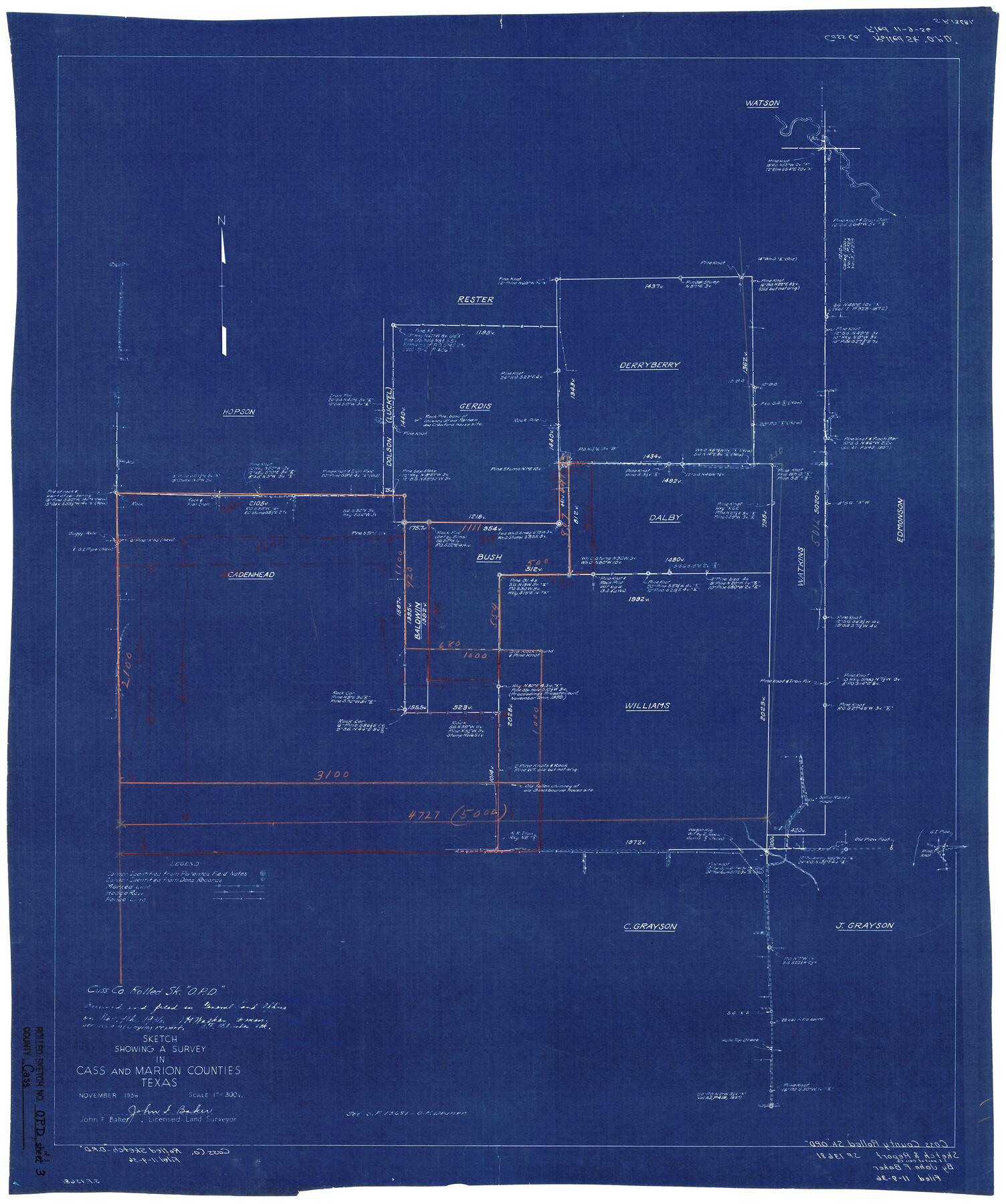
Cass County Rolled Sketch OPD
Sketch showing a survey in Cass and Marion Counties, Texas [Sheet 3 of 3]
-
Map/Doc
5484
-
Collection
General Map Collection
-
Object Dates
11/1936 (Creation Date)
11/9/1936 (File Date)
-
People and Organizations
John F. Baker (Surveyor/Engineer)
-
Counties
Cass Marion
-
Subjects
Surveying Rolled Sketch
-
Height x Width
29.6 x 26.1 inches
75.2 x 66.3 cm
-
Medium
blueprint/diazo
-
Scale
1" = 300 varas
-
Comments
See SF-13681. See Cass County Sketch File 25 (17444) for surveyor’s report.
Related maps
Cass County Sketch File 25

Print $14.00
- Digital $50.00
Cass County Sketch File 25
1936
Size 14.3 x 8.9 inches
Map/Doc 17444
Part of: General Map Collection

Lee County Working Sketch 16

Print $20.00
- Digital $50.00
Lee County Working Sketch 16
1982
Size 20.5 x 13.5 inches
Map/Doc 70395
Connected Map of Austin's Colony

Print $20.00
- Digital $50.00
Connected Map of Austin's Colony
1833
Size 38.1 x 36.1 inches
Map/Doc 88999
Martin County Sketch File 9

Print $20.00
Martin County Sketch File 9
Size 19.7 x 27.4 inches
Map/Doc 12029
Collin County Sketch File 14

Print $12.00
- Digital $50.00
Collin County Sketch File 14
1953
Size 11.2 x 8.7 inches
Map/Doc 18874
Motley County Sketch File 2 (N)

Print $22.00
- Digital $50.00
Motley County Sketch File 2 (N)
Size 8.3 x 14.8 inches
Map/Doc 31996
Harrison County Working Sketch 32

Print $20.00
- Digital $50.00
Harrison County Working Sketch 32
2015
Size 29.9 x 24.0 inches
Map/Doc 93724
Hutchinson County Working Sketch 43

Print $20.00
- Digital $50.00
Hutchinson County Working Sketch 43
1978
Size 26.6 x 22.3 inches
Map/Doc 66403
Carta Orografica

Print $20.00
- Digital $50.00
Carta Orografica
Size 26.0 x 34.4 inches
Map/Doc 96802
Pecos County Working Sketch 87

Print $20.00
- Digital $50.00
Pecos County Working Sketch 87
1962
Size 29.0 x 31.6 inches
Map/Doc 71559
Crockett County Rolled Sketch E

Print $20.00
- Digital $50.00
Crockett County Rolled Sketch E
1907
Size 26.2 x 27.7 inches
Map/Doc 5636
Young County Sketch File 18

Print $10.00
- Digital $50.00
Young County Sketch File 18
1929
Size 11.5 x 8.7 inches
Map/Doc 40882
You may also like
Frio County Rolled Sketch 12A

Print $20.00
- Digital $50.00
Frio County Rolled Sketch 12A
1948
Size 40.0 x 45.2 inches
Map/Doc 8905
Flight Mission No. BRE-1P, Frame 117, Nueces County

Print $20.00
- Digital $50.00
Flight Mission No. BRE-1P, Frame 117, Nueces County
1956
Size 18.4 x 22.3 inches
Map/Doc 86683
King County Rolled Sketch 10

Print $20.00
- Digital $50.00
King County Rolled Sketch 10
Size 38.9 x 33.7 inches
Map/Doc 6532


Madison County Rolled Sketch 1

Print $20.00
- Digital $50.00
Madison County Rolled Sketch 1
1966
Size 36.7 x 46.0 inches
Map/Doc 9485
[Copy of a portion of] The Coast & Bays of Western Texas, St. Joseph's and Mustang Islands from Actual Survey, the Remainder from County Maps, Etc.
![72769, [Copy of a portion of] The Coast & Bays of Western Texas, St. Joseph's and Mustang Islands from Actual Survey, the Remainder from County Maps, Etc., General Map Collection](https://historictexasmaps.com/wmedia_w700/maps/72769.tif.jpg)
Print $20.00
- Digital $50.00
[Copy of a portion of] The Coast & Bays of Western Texas, St. Joseph's and Mustang Islands from Actual Survey, the Remainder from County Maps, Etc.
1857
Size 25.9 x 18.3 inches
Map/Doc 72769
Brewster County Rolled Sketch 94

Print $40.00
- Digital $50.00
Brewster County Rolled Sketch 94
1941
Size 26.8 x 58.6 inches
Map/Doc 8507
Val Verde County Rolled Sketch 3

Print $20.00
- Digital $50.00
Val Verde County Rolled Sketch 3
1887
Size 44.8 x 36.5 inches
Map/Doc 10070
Sutton County Working Sketch 66

Print $20.00
- Digital $50.00
Sutton County Working Sketch 66
1972
Size 29.0 x 39.3 inches
Map/Doc 62409
Zapata County Working Sketch 25

Print $40.00
- Digital $50.00
Zapata County Working Sketch 25
2009
Size 36.9 x 71.8 inches
Map/Doc 89051
[Gulf Colorado & Santa Fe from 2178+36.0 to 3901+06.2]
![64695, [Gulf Colorado & Santa Fe from 2178+36.0 to 3901+06.2], General Map Collection](https://historictexasmaps.com/wmedia_w700/maps/64695-1.tif.jpg)
Print $40.00
- Digital $50.00
[Gulf Colorado & Santa Fe from 2178+36.0 to 3901+06.2]
Size 33.6 x 120.7 inches
Map/Doc 64695