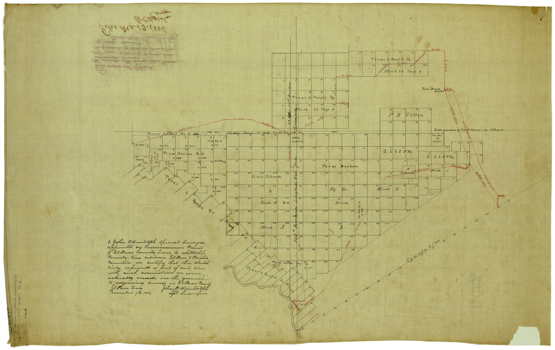
Culberson County Rolled Sketch 9
[Sketch in the south part of Culberson & Hudspeth Counties, Texas]
-
Map/Doc
5646
-
Collection
General Map Collection
-
Object Dates
12/7/1886 (Creation Date)
12/13/1886 (File Date)
-
People and Organizations
John P. Randolph (Surveyor/Engineer)
-
Counties
Culberson Hudspeth
-
Subjects
Surveying Rolled Sketch
-
Height x Width
28.3 x 41.9 inches
71.9 x 106.4 cm
-
Medium
linen, manuscript
Part of: General Map Collection
El Paso County Working Sketch 6

Print $20.00
- Digital $50.00
El Paso County Working Sketch 6
1928
Size 25.4 x 16.7 inches
Map/Doc 69028
Titus County Sketch File 5

Print $4.00
- Digital $50.00
Titus County Sketch File 5
1853
Size 11.7 x 8.2 inches
Map/Doc 38138
Crane County Sketch File 29

Print $6.00
- Digital $50.00
Crane County Sketch File 29
1930
Size 12.8 x 10.4 inches
Map/Doc 19608
Kerr County Working Sketch 23

Print $20.00
- Digital $50.00
Kerr County Working Sketch 23
1966
Size 33.4 x 41.0 inches
Map/Doc 70054
Flight Mission No. BRA-16M, Frame 150, Jefferson County

Print $20.00
- Digital $50.00
Flight Mission No. BRA-16M, Frame 150, Jefferson County
1953
Size 18.5 x 22.3 inches
Map/Doc 85756
Map of the Texas & Pacific Railway from Fort Worth to El Paso

Print $40.00
- Digital $50.00
Map of the Texas & Pacific Railway from Fort Worth to El Paso
Size 24.0 x 76.5 inches
Map/Doc 64511
Hutchinson County Rolled Sketch 44-18

Print $20.00
- Digital $50.00
Hutchinson County Rolled Sketch 44-18
2002
Size 24.0 x 36.0 inches
Map/Doc 77554
Guadalupe County Sketch File 25

Print $22.00
- Digital $50.00
Guadalupe County Sketch File 25
Size 12.7 x 15.7 inches
Map/Doc 24717
Hunt County Rolled Sketch 5

Print $20.00
- Digital $50.00
Hunt County Rolled Sketch 5
1956
Size 27.5 x 24.3 inches
Map/Doc 6269
Kent County Boundary File 4a

Print $18.00
- Digital $50.00
Kent County Boundary File 4a
Size 14.2 x 8.5 inches
Map/Doc 55838
Flight Mission No. BRE-2P, Frame 95, Nueces County

Print $20.00
- Digital $50.00
Flight Mission No. BRE-2P, Frame 95, Nueces County
1956
Size 18.4 x 22.3 inches
Map/Doc 86780
Colorado County Working Sketch 35

Print $20.00
- Digital $50.00
Colorado County Working Sketch 35
Size 19.8 x 15.8 inches
Map/Doc 76065
You may also like
Corpus Christi, Where Texas Meets the Sea

Corpus Christi, Where Texas Meets the Sea
1927
Size 9.6 x 4.3 inches
Map/Doc 97064
Travis County Rolled Sketch 14

Print $20.00
- Digital $50.00
Travis County Rolled Sketch 14
1939
Size 30.5 x 22.3 inches
Map/Doc 8017
Knox County Working Sketch 6

Print $20.00
- Digital $50.00
Knox County Working Sketch 6
1937
Size 31.4 x 18.2 inches
Map/Doc 70248
Location of the Southern Kansas Railway of Texas, Gray County, Texas

Print $40.00
- Digital $50.00
Location of the Southern Kansas Railway of Texas, Gray County, Texas
1887
Size 19.9 x 75.3 inches
Map/Doc 64036
Brown County Sketch File 5

Print $40.00
- Digital $50.00
Brown County Sketch File 5
1858
Size 17.9 x 15.8 inches
Map/Doc 11017
Atascosa County Working Sketch 28

Print $20.00
- Digital $50.00
Atascosa County Working Sketch 28
1968
Size 38.5 x 26.3 inches
Map/Doc 67224

Victoria County Sketch File 11

Print $8.00
- Digital $50.00
Victoria County Sketch File 11
1985
Size 11.3 x 9.0 inches
Map/Doc 39536
Edwards County Sketch File 46

Print $26.00
- Digital $50.00
Edwards County Sketch File 46
1954
Size 11.3 x 8.7 inches
Map/Doc 21792
Tyler County Working Sketch 13

Print $20.00
- Digital $50.00
Tyler County Working Sketch 13
1957
Size 34.5 x 38.5 inches
Map/Doc 69483
Wilbarger Co.

Print $40.00
- Digital $50.00
Wilbarger Co.
1889
Size 48.2 x 39.0 inches
Map/Doc 63124
[Block N and part of Block B]
![90363, [Block N and part of Block B], Twichell Survey Records](https://historictexasmaps.com/wmedia_w700/maps/90363-1.tif.jpg)
Print $3.00
- Digital $50.00
[Block N and part of Block B]
Size 9.6 x 12.8 inches
Map/Doc 90363