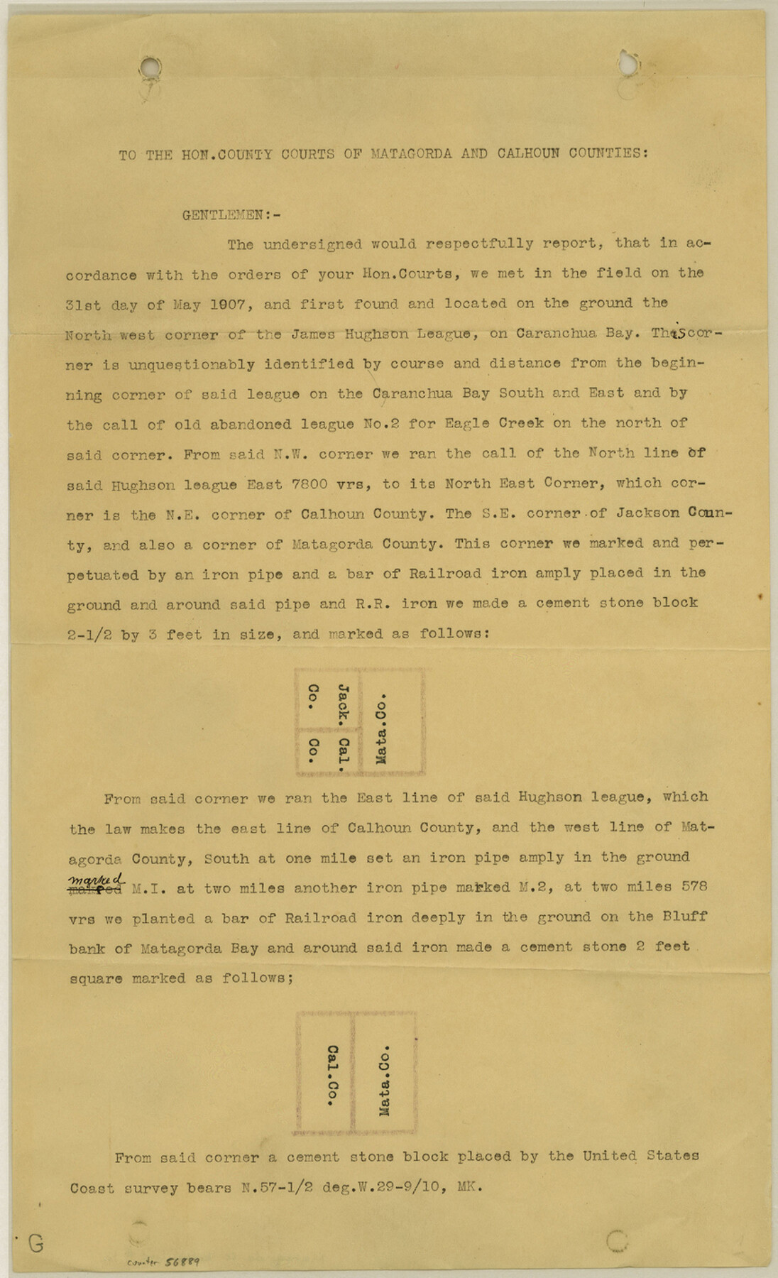
Matagorda County Boundary File 1a
Report to Court
-
Map/Doc
56889
-
Collection
General Map Collection
-
Counties
Matagorda
-
Subjects
County Boundaries
-
Height x Width
14.2 x 8.6 inches
36.1 x 21.8 cm
Part of: General Map Collection
[Map showing the location of the Pecos Valley Railway through H. &. G. N. R.R. Co. Land in Reeves Co., Texas]
![64706, [Map showing the location of the Pecos Valley Railway through H. &. G. N. R.R. Co. Land in Reeves Co., Texas], General Map Collection](https://historictexasmaps.com/wmedia_w700/maps/64706.tif.jpg)
Print $40.00
- Digital $50.00
[Map showing the location of the Pecos Valley Railway through H. &. G. N. R.R. Co. Land in Reeves Co., Texas]
1891
Size 38.5 x 118.2 inches
Map/Doc 64706
Flight Mission No. DQN-1K, Frame 142, Calhoun County

Print $20.00
- Digital $50.00
Flight Mission No. DQN-1K, Frame 142, Calhoun County
1953
Size 18.8 x 22.3 inches
Map/Doc 84205
Kleberg County Aerial Photograph Index Sheet 5

Print $20.00
- Digital $50.00
Kleberg County Aerial Photograph Index Sheet 5
1956
Size 19.5 x 23.5 inches
Map/Doc 83722
The Making of America - Texas

The Making of America - Texas
1986
Size 20.7 x 27.3 inches
Map/Doc 96825
[Surveys in Austin's Colony along Chocolate Bayou and Austin Bayou]
![192, [Surveys in Austin's Colony along Chocolate Bayou and Austin Bayou], General Map Collection](https://historictexasmaps.com/wmedia_w700/maps/192.tif.jpg)
Print $20.00
- Digital $50.00
[Surveys in Austin's Colony along Chocolate Bayou and Austin Bayou]
1830
Size 32.9 x 10.8 inches
Map/Doc 192
Brazoria County Rolled Sketch 23

Print $20.00
- Digital $50.00
Brazoria County Rolled Sketch 23
1931
Size 39.2 x 37.3 inches
Map/Doc 10691
Uvalde County Sketch File 24

Print $42.00
- Digital $50.00
Uvalde County Sketch File 24
1926
Size 19.4 x 29.9 inches
Map/Doc 12536
Tom Green County Sketch File 30

Print $12.00
Tom Green County Sketch File 30
1880
Size 11.0 x 8.2 inches
Map/Doc 38182
Chambers County

Print $20.00
- Digital $50.00
Chambers County
1862
Size 20.2 x 27.8 inches
Map/Doc 3381
Intracoastal Waterway in Texas - Corpus Christi to Point Isabel including Arroyo Colorado to Mo. Pac. R.R. Bridge Near Harlingen

Print $20.00
- Digital $50.00
Intracoastal Waterway in Texas - Corpus Christi to Point Isabel including Arroyo Colorado to Mo. Pac. R.R. Bridge Near Harlingen
1933
Size 40.9 x 27.8 inches
Map/Doc 61874
Titus County Sketch File 5

Print $4.00
- Digital $50.00
Titus County Sketch File 5
1853
Size 11.7 x 8.2 inches
Map/Doc 38138
Crockett County Rolled Sketch 80

Print $20.00
- Digital $50.00
Crockett County Rolled Sketch 80
Size 14.0 x 28.5 inches
Map/Doc 5620
You may also like
Clay County Rolled Sketch 5

Print $20.00
- Digital $50.00
Clay County Rolled Sketch 5
Size 21.0 x 23.6 inches
Map/Doc 5499
Flight Mission No. DQN-3K, Frame 66, Calhoun County

Print $20.00
- Digital $50.00
Flight Mission No. DQN-3K, Frame 66, Calhoun County
1953
Size 18.7 x 22.5 inches
Map/Doc 84357
Terry County Boundary File 3

Print $78.00
- Digital $50.00
Terry County Boundary File 3
Size 7.4 x 8.8 inches
Map/Doc 59216
Map of Potter County

Print $20.00
- Digital $50.00
Map of Potter County
1895
Size 23.6 x 18.6 inches
Map/Doc 4589
[Wilson Strickland Survey]
![91285, [Wilson Strickland Survey], Twichell Survey Records](https://historictexasmaps.com/wmedia_w700/maps/91285-1.tif.jpg)
Print $20.00
- Digital $50.00
[Wilson Strickland Survey]
Size 12.7 x 19.2 inches
Map/Doc 91285
Shelby County Sketch File 27

Print $4.00
- Digital $50.00
Shelby County Sketch File 27
Size 6.5 x 8.0 inches
Map/Doc 36662
Clay County Sketch File 42

Print $20.00
- Digital $50.00
Clay County Sketch File 42
Size 22.8 x 31.0 inches
Map/Doc 11093
San Jacinto County Working Sketch 22

Print $20.00
- Digital $50.00
San Jacinto County Working Sketch 22
1940
Size 21.3 x 25.3 inches
Map/Doc 63735
Hockley County Sketch File M

Print $20.00
- Digital $50.00
Hockley County Sketch File M
Size 22.2 x 25.8 inches
Map/Doc 11777
Coleman County

Print $40.00
- Digital $50.00
Coleman County
1897
Size 49.4 x 34.9 inches
Map/Doc 66758
[Plan for Fort Waul near Gonzales, Texas]
![88600, [Plan for Fort Waul near Gonzales, Texas], National Archives Digital Map Collection](https://historictexasmaps.com/wmedia_w700/maps/88600.tif.jpg)
Print $20.00
[Plan for Fort Waul near Gonzales, Texas]
1863
Size 12.3 x 20.3 inches
Map/Doc 88600
