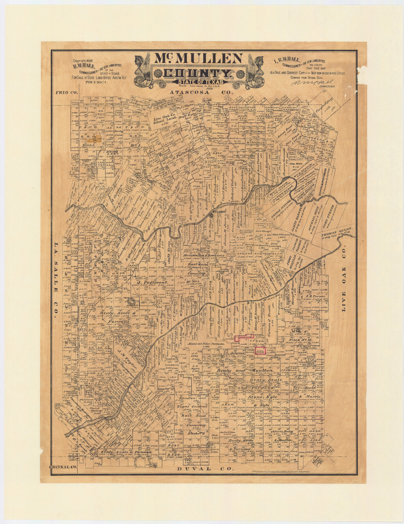
McMullen County, Texas
-
Map/Doc
575
-
Collection
Maddox Collection
-
Object Dates
1889 (Creation Date)
1888 (Copyright Date)
-
People and Organizations
General Land Office (Publisher)
R.M. Hall (GLO Commissioner)
August Gast & Co. (Lithographer)
-
Counties
McMullen
-
Subjects
County
-
Height x Width
28.7 x 22.1 inches
72.9 x 56.1 cm
-
Medium
paper, etching/engraving/lithograph
-
Scale
1:4000
-
Comments
Conservation funded in 2009 by Friends of the Texas General Land Office.
-
Features
Mule Creek
San Patricio [Creek]
Mirasol Creek
Ygnacia Creek
Loma Alto [Mountain]
Cow Creek
Hill Creek
San Kaho [Mountain]
San Fernando Creek
Bushy Hills
Raw Hide Creek
Rio Nueces
Elm Creek
Frio River
Tilden
Leoncito Creek
Laredo Road
Willow Creek
Esparanza Creek
Part of: Maddox Collection
Sketch showing OX lands in the Yarbrough Pasture
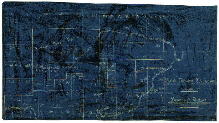
Print $20.00
- Digital $50.00
Sketch showing OX lands in the Yarbrough Pasture
Size 14.0 x 25.2 inches
Map/Doc 4433
Lynn County, Texas

Print $20.00
- Digital $50.00
Lynn County, Texas
1883
Size 19.0 x 18.3 inches
Map/Doc 739
[Surveying Sketch of T. & N. O. R. R. Co., S. P. R. R. Co., E. T. R. R. Co., et al in Dallam, Hartley, Sherman & Moore Counties, Texas]
![75824, [Surveying Sketch of T. & N. O. R. R. Co., S. P. R. R. Co., E. T. R. R. Co., et al in Dallam, Hartley, Sherman & Moore Counties, Texas], Maddox Collection](https://historictexasmaps.com/wmedia_w700/maps/75824.tif.jpg)
Print $20.00
- Digital $50.00
[Surveying Sketch of T. & N. O. R. R. Co., S. P. R. R. Co., E. T. R. R. Co., et al in Dallam, Hartley, Sherman & Moore Counties, Texas]
Size 17.5 x 22.1 inches
Map/Doc 75824
Sketch in Uvalde County

Print $20.00
- Digital $50.00
Sketch in Uvalde County
1890
Size 12.3 x 15.9 inches
Map/Doc 5049
Survey 1, Block 1, D.B. Gardner in Dickens County

Print $20.00
- Digital $50.00
Survey 1, Block 1, D.B. Gardner in Dickens County
1914
Size 14.9 x 30.4 inches
Map/Doc 10767
Exhibit A to the Surveyors Report, R.W. Lillard vs J.M. Taylor, et al

Print $20.00
- Digital $50.00
Exhibit A to the Surveyors Report, R.W. Lillard vs J.M. Taylor, et al
1881
Size 12.4 x 12.9 inches
Map/Doc 683
Austin and Surrounding Properties
.tif.jpg)
Print $20.00
- Digital $50.00
Austin and Surrounding Properties
1891
Size 42.9 x 32.1 inches
Map/Doc 421
Plat of Ingleside and Garden Tracts

Print $20.00
- Digital $50.00
Plat of Ingleside and Garden Tracts
1890
Size 25.4 x 30.4 inches
Map/Doc 661
Sketch of part of the NW part, Hutchinson County

Print $20.00
- Digital $50.00
Sketch of part of the NW part, Hutchinson County
1909
Size 20.9 x 31.2 inches
Map/Doc 75816
Refugio County, Texas

Print $20.00
- Digital $50.00
Refugio County, Texas
1879
Size 19.9 x 29.0 inches
Map/Doc 600
[Marion County, Texas]
![75777, [Marion County, Texas], Maddox Collection](https://historictexasmaps.com/wmedia_w700/maps/75777.tif.jpg)
Print $20.00
- Digital $50.00
[Marion County, Texas]
1901
Size 26.5 x 24.1 inches
Map/Doc 75777
Map of Galveston County, Texas

Print $20.00
- Digital $50.00
Map of Galveston County, Texas
1879
Size 18.3 x 26.6 inches
Map/Doc 546
You may also like
Austin County

Print $20.00
- Digital $50.00
Austin County
1943
Size 40.1 x 42.5 inches
Map/Doc 73073
Oil and Gas Fields of the State of Texas

Print $40.00
- Digital $50.00
Oil and Gas Fields of the State of Texas
1931
Size 38.4 x 59.2 inches
Map/Doc 89885

Shelby County Sketch File 12

Print $4.00
- Digital $50.00
Shelby County Sketch File 12
Size 8.2 x 10.3 inches
Map/Doc 36619
Matagorda County NRC Article 33.136 Sketch 15

Print $42.00
- Digital $50.00
Matagorda County NRC Article 33.136 Sketch 15
Size 23.8 x 35.9 inches
Map/Doc 95739
San Augustine County Working Sketch 15

Print $20.00
- Digital $50.00
San Augustine County Working Sketch 15
1959
Size 26.6 x 36.7 inches
Map/Doc 63703
Real County Sketch File 18

Print $28.00
- Digital $50.00
Real County Sketch File 18
1964
Size 14.3 x 8.9 inches
Map/Doc 35076
Gillespie County Sketch File 14

Print $6.00
- Digital $50.00
Gillespie County Sketch File 14
1880
Size 10.1 x 11.4 inches
Map/Doc 24155
Tarrant County Sketch File 16

Print $4.00
- Digital $50.00
Tarrant County Sketch File 16
1861
Size 8.2 x 6.4 inches
Map/Doc 37710
Wharton County Rolled Sketch 5

Print $20.00
- Digital $50.00
Wharton County Rolled Sketch 5
1899
Size 19.3 x 24.6 inches
Map/Doc 8229
Throckmorton County Working Sketch 6

Print $20.00
- Digital $50.00
Throckmorton County Working Sketch 6
1952
Size 24.7 x 21.7 inches
Map/Doc 62115
Walker County Working Sketch 15

Print $20.00
- Digital $50.00
Walker County Working Sketch 15
1967
Size 26.9 x 24.8 inches
Map/Doc 72295