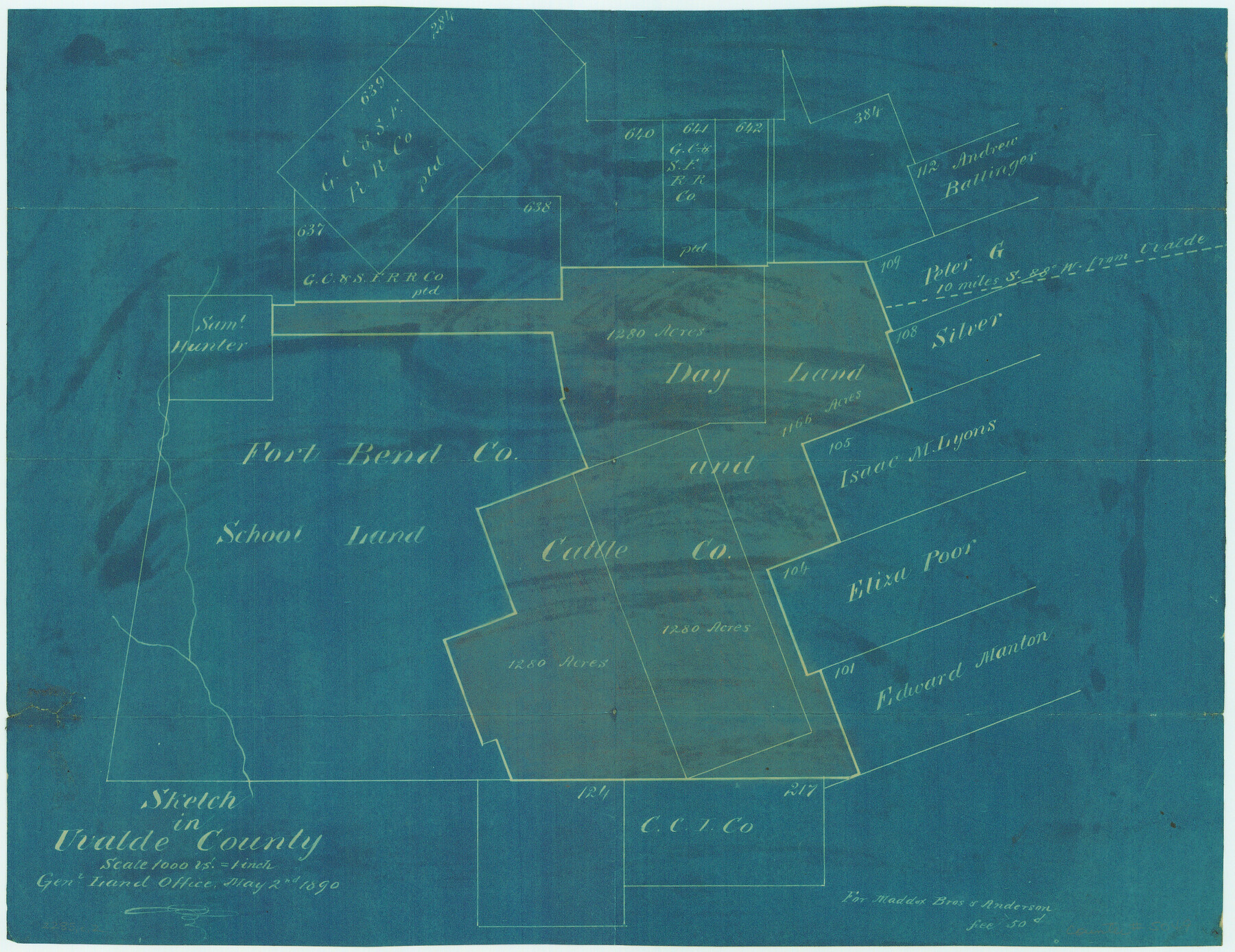
Sketch in Uvalde County
-
Map/Doc
5049
-
Collection
Maddox Collection
-
Object Dates
1890/5/2 (Creation Date)
-
People and Organizations
GLO (Author)
-
Counties
Uvalde
-
Height x Width
12.3 x 15.9 inches
31.2 x 40.4 cm
-
Medium
blueprint/diazo
-
Scale
1000 varas = 1 inch
-
Comments
Copied for Maddox Bros. & Anderson for a fee of 50 cents.
Part of: Maddox Collection
Map of Part of the YL Ranch

Print $20.00
- Digital $50.00
Map of Part of the YL Ranch
1917
Size 29.1 x 27.3 inches
Map/Doc 4442
Resurvey of H.L. Upshur's April 23, 1853 meanders of the Colorado River from the NE corner of Isaac Decker league to the Congress Avenue Bridge

Print $20.00
- Digital $50.00
Resurvey of H.L. Upshur's April 23, 1853 meanders of the Colorado River from the NE corner of Isaac Decker league to the Congress Avenue Bridge
1915
Size 24.1 x 15.8 inches
Map/Doc 75774
Dawson County, Texas

Print $20.00
- Digital $50.00
Dawson County, Texas
1880
Size 28.6 x 20.5 inches
Map/Doc 705
Austin and Surrounding Properties
.tif.jpg)
Print $20.00
- Digital $50.00
Austin and Surrounding Properties
1891
Size 42.9 x 32.1 inches
Map/Doc 421
Map of Cherokee County, Texas

Print $20.00
- Digital $50.00
Map of Cherokee County, Texas
1879
Size 30.8 x 24.0 inches
Map/Doc 696
Map of part of Waller County

Print $20.00
- Digital $50.00
Map of part of Waller County
Size 16.3 x 13.5 inches
Map/Doc 685
Sketch compiled from records of Collin County in General Land Office

Print $3.00
- Digital $50.00
Sketch compiled from records of Collin County in General Land Office
1878
Size 11.5 x 13.5 inches
Map/Doc 504
Deaf Smith County, Texas

Print $20.00
- Digital $50.00
Deaf Smith County, Texas
1880
Size 22.9 x 25.6 inches
Map/Doc 678
"La Gloria Ranch", Duval Co. Texas

Print $20.00
- Digital $50.00
"La Gloria Ranch", Duval Co. Texas
Size 12.0 x 15.1 inches
Map/Doc 431
[Surveying sketch of Jones County showing Micaela Fiagoso survey]
![387, [Surveying sketch of Jones County showing Micaela Fiagoso survey], Maddox Collection](https://historictexasmaps.com/wmedia_w700/maps/0387-1.tif.jpg)
Print $20.00
- Digital $50.00
[Surveying sketch of Jones County showing Micaela Fiagoso survey]
Size 19.5 x 16.8 inches
Map/Doc 387
[Sketch of Surveys in Cottle, Dickens, King & Motley Counties, Texas]
![75830, [Sketch of Surveys in Cottle, Dickens, King & Motley Counties, Texas], Maddox Collection](https://historictexasmaps.com/wmedia_w700/maps/75830.tif.jpg)
Print $20.00
- Digital $50.00
[Sketch of Surveys in Cottle, Dickens, King & Motley Counties, Texas]
1913
Size 29.6 x 23.2 inches
Map/Doc 75830
Map of West Part of Galveston County, Texas

Print $20.00
- Digital $50.00
Map of West Part of Galveston County, Texas
1880
Size 28.6 x 21.9 inches
Map/Doc 716
You may also like
Travis County Working Sketch 29

Print $20.00
- Digital $50.00
Travis County Working Sketch 29
1960
Size 25.6 x 29.9 inches
Map/Doc 69413
Harris County Working Sketch 111

Print $20.00
- Digital $50.00
Harris County Working Sketch 111
1982
Size 21.7 x 16.0 inches
Map/Doc 66003

Maps & Lists Showing Prison Lands (Oil & Gas) Leased as of June 1955

Digital $50.00
Maps & Lists Showing Prison Lands (Oil & Gas) Leased as of June 1955
Size 11.1 x 8.8 inches
Map/Doc 62873
Flight Mission No. CGI-3N, Frame 129, Cameron County

Print $20.00
- Digital $50.00
Flight Mission No. CGI-3N, Frame 129, Cameron County
1954
Size 18.5 x 22.2 inches
Map/Doc 84602
Flight Mission No. CUG-2P, Frame 83, Kleberg County

Print $20.00
- Digital $50.00
Flight Mission No. CUG-2P, Frame 83, Kleberg County
1956
Size 18.5 x 22.3 inches
Map/Doc 86215
Lubbock County Boundary File 1

Print $64.00
- Digital $50.00
Lubbock County Boundary File 1
Size 8.8 x 8.6 inches
Map/Doc 56455
Terry County Sketch File 9

Print $4.00
- Digital $50.00
Terry County Sketch File 9
1917
Size 14.4 x 8.8 inches
Map/Doc 38032
Cameron County Sketch File 1

Print $7.00
- Digital $50.00
Cameron County Sketch File 1
1849
Size 10.9 x 8.6 inches
Map/Doc 36024
Johnson County Working Sketch 20

Print $20.00
- Digital $50.00
Johnson County Working Sketch 20
1991
Size 23.4 x 29.0 inches
Map/Doc 66633
[Sketch showing west part of county]
![91712, [Sketch showing west part of county], Twichell Survey Records](https://historictexasmaps.com/wmedia_w700/maps/91712-1.tif.jpg)
Print $3.00
- Digital $50.00
[Sketch showing west part of county]
1907
Size 16.4 x 11.1 inches
Map/Doc 91712
Donley County Sketch File 22

Print $20.00
- Digital $50.00
Donley County Sketch File 22
Size 20.4 x 28.0 inches
Map/Doc 11368